Thanks to a strategically placed forest fire, the California
Highway Patrol closed Hwy. 395 just south of Big Pine and forced
our ride home from a Yosemite trip onto a long and arduous detour.
The CHP's recommended detour to Los Angeles was to head through
Tonopah or Beatty, Nev., and then through Death Valley and onto
I-15 in Baker.
Yeah, right! We were fortunately armed with our Jeep, so we
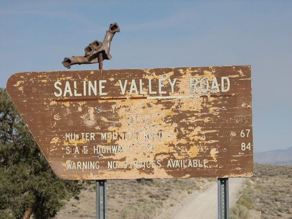
opted to take a hastily arranged "shortcut" down Saline Valley
Road. Well OK, 85 miles of washboard dirt road isn't exactly a
SHORT shortcut, but it did put us down on Hwy. 190, where we were
able to cut through Trona and spend the night with family in
Ridgecrest. It might have been a 5-hour drive, but at least we
didn't have to leave the state to get home. That just seems
wrong.
Now, the very reason that we were coming home via US-395 in the
first place was because we wanted to visit the Reward Mine (for
those not in the know, it's an abandoned mine a few miles east of
Manzanar and is big enough to drive a truck through). Thanks to the
highway closure, we not only got sent HOURS out of our way, we also
failed in our mission to visit the mine. Phooey!
Well, as a consolation to ourselves, we left an ammo can along
the road, so we could at least lift our spirits a little bit. This
one's a 50-cal ammo can near some old mining relics. There are much
more interesting relics over the course of a few miles to the
south, but they're all inside the national park boundary (which
doesn't show up on some maps, but it's there!). For obvious
reasons, we hid the cache several hundred feet outside the boundary
to Death Valley, and these bitty little ruins are the best that
this stretch of the Inyo National Forest had to offer.
If you do plan to continue south on Saline Valley Road, be sure
to have plenty of food, water, and TIME (at least 4-5 hours, longer
if you wish to explore the intersecting trails). The road should be
passable in its entirety to anyone in a standard-clearance 2WD
truck or a stock Subaru...although street tires are not recommended
and conditions may vary depending on the weather. It was definitely
an interesting drive--there was even a lake and a couple of water
crossings--but we sure wish it hadn't been an unplanned trip. By
the way, did I mention that it was well over 100 degrees by the
time we got down there? That made the half-hour spent fixing a tire
problem a lot of fun. Oh yeah, did I also mention that our Jeep
doesn't have air conditioning? Which reminds me...please re-hide
the cache carefully. Cuz if I have to come out and replace a
missing cache...well, you'll just make me cranky.
Good luck, and Happy Caching!