De Örenberg EarthCache
-
Difficulty:
-

-
Terrain:
-

Size:  (other)
Please note Use of geocaching.com services is subject to the terms and conditions
in our disclaimer.
Örenberg Conglomeraat
Maasgrind aaneengekit door kalkwater.
 Nederlands
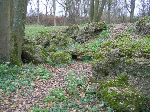
De geologische ondergrond van Zuid-Limburg herbergt kleine landschapselementen die iets vertellen over de geschiedenis van het Heuvelland. Hier ligt het zogenaamde "Örenberg-conglomeraat".
Tussen 1.000.000 en 800.000 jaar geleden stroomde de Maas vanuit de Vogezen en Ardennen over de Örenberg. Het water van de rivier nam daarbij grind, zand en klei mee. Op bovengenoemde coordinaten spoelde een acht meter dikke laag grind en klei aan.
Kalkrijk water dat door deze laag naar beneden sijpelde, vulde de poriën van de grind en klei op met kalk. Na verharding ondstond een natuurlijk "beton". Deze zeldzame geologische afzetting staat bekend onder de naam "Örenberg-conglomeraat".
De volgende opdrachten moeten uitgevoerd worden om deze Earthcache te mogen loggen.
Opdracht: Hoe heet de laag gesteente die zich onder het "Örenberg-conglomeraat" bevindt? Stuur dit antwoord op naar FerryStreens&Fairyglitters.
Foto: maak een foto van jezelf met je GPS bij het geologisch monument en plaats deze foto bij de log.
LOGS MET EEN VERKEERDE FOTO OF LOGS VAN MENSEN DIE EEN FOUT ANTWOORD OP DE VRAAG GEMAILD HEBBEN WORDEN DIRECT VERWIJDERD!!!
 English
Örenberg conglomerate
Gravel of the river Meuse glued together by limewater.
The geological subsoil of Southern Limburg contains small landscape features that tell us about the history of the hills of Limburg. At the above mentioned coordinates you'll find the so-called Örenberg-conglomerate.
Between a 1.000.000 and 800.000 years ago the river Meuse, that came from the Vosges and the Ardennes, ran through the Örenberg. This current carried gravel, sand and clay. An 8 metres thick layer gravel and clay was deposited at the Örenberg by the Meuse.
Limy water that oozed down through this layer filled the pores of the gravel and clay with lime. After hardening a natural "concrete" was formed. This rare geological sediment is known by the name "Örenberg-conglomerate".
The following actions must be completed to succesfully log this Earthcache.
Assignment: How is the earthlayer called that is found under the "Örenberg-conglomerate". E-mail this answer to FerryStreens&Fairyglitters.
Photo: make a picture of yourself together with your GPS, and add this picture to the log.
LOGS WITH A WRONG PICTURE OR LOGS FROM PEOPLE THAT E-MAILED INCORRECT ANSWERS TO THE QUESTION ARE REMOVED IMMEDIATELY!!!
Additional Hints
(Decrypt)
[NL] Urg nagjbbeq vf AVRG: Öeraoret-pbatybzrenng bs anghheyvwx orgba.
[UK] Gur nafjre vf ABG: Öeraoret-pbatybzrengr be angheny pbapergr.