|

Sintra: Upheaval 90 M.a
The Sintra Mountain, located 30 km west of the Lisbon city centre, is 10 km long and 5 km wide. In the west the mountain is truncated by 150 m-high sheer cliffs at Cabo the Roca. The maximum height above mean sea level is 528 m at Cruz Alta. 
Over the centuries Sintra has been chosen as the ideal location of places of meditation by monks, for royal palaces by kings and queens alike (Pena, Seteais), the location of gardens of extreme beauty, properties of wealthy business men and described as a glorious eden by the poet Byron.
All this is possible because at around 90 million years, when in the Upper Cretaceous period, a body of less dense granitic magma propelled itself upwards through the existing Jurassic lithologies (essentially limestones) and solidified at just the right spot to allow mere mortals to enjoy the wonderful views from this mass of granite as well as text book examples of some geological features.
The upheaval of this mass of rock has caused the adjacent Jurassic lithologies, that were originally horizontal to become ever more inclined as you move towards the contact of the limestones and granite.
What is stratigraphy?
Stratigraphy is basically the study of rock layers and layering (stratification). It is primarily used in the study of sedimentary and layered volcanic rocks. The subject was essentially invented and first rigorously applied by William Smith in England in the 1790s and early 1800s.
Stratigraphy includes two related subfields: lithologic or lithostratigraphy and biologic stratigraphy or biostratigraphy. Lithostratigraphy, or lithologic stratigraphy, is the most obvious. It deals with the physical lithological or rock type change both vertically in layering or bedding of varying rock type and laterally reflecting changing environments of deposition, known as facies change. Key elements of stratigraphy involve understanding how certain geometric relationships between rock layers arise and what these geometries mean in terms of depositional environment. One of stratigraphy's basic concepts is codified in the Law of Superposition, which simply states that, in an undeformed stratigraphic sequence, the oldest strata occur at the base of the sequence.
Biostratigraphy or paleontologic stratigraphy is based on fossil evidence in the rock layers. Strata from widespread locations containing the same fossil fauna and flora are correlatable in time. Biologic stratigraphy was based on William Smith's principle of faunal succession, which predated, and was one of the first and most powerful lines of evidence for, biological evolution. It provides strong evidence for formation (speciation) of and the extinction of species. The geologic time scale was developed during the 1800s based on the evidence of biologic stratigraphy and faunal succession. This timescale remained a relative scale until the development of radiometric dating, which gave it and the stratigraphy it was based on an absolute time framework, leading to the development of chronostratigraph.
Measuring stratigraphy
· One way to think of the strike is it represents the compass direction (azimuth) of the trace of a layer across the surface of the Earth, if the surface is approximately horizontal. This means a measurement of the strike will tell you the direction a layer should appear on a geological map.
· The dip is the angle of inclination of the layer with respect to the surface. This angle is measured perpendicular to the strike.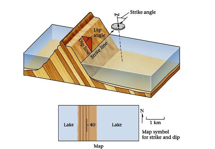
Measuring strike:
We will begin by taking the strike of a bedding plane. For these measurements we will use a Brunton compass like the one you see in the pictures above. In order to measure the strike, place the side or edge of the compass against the plane of the outcrop. Sometimes it is easier to put your field book against the outcrop and then the compass against the book to get a smoother and/or a larger surface. Now, rotate the compass keeping the lower side edge of the compass fixed, until the bulls-eye level bubble is centered (the round tube; not the long narrow one). When the bubble is centered, the compass is horizontal against the plane and parallel to the line of strike. Now, with the bulls-eye bubble centered, record the number that either end of the compass needle is showing.
In other words:
- Place the bottom EDGE of the compass flat against the plane of interest.
- Adjust the compass orientation, making sure the bottom edge is always flat against the plane, until the air bubble in the "Bull's eye level" is centered.
- Read either end of the compass needle to obtain the value of strike.
Measuring Dip:
To measure the dip of the bedding plane, take your compass and put its side against the rock so that it points in the same direction as the line of dip (The dip line is perpendicular to the strike line). Move the clinometer until the clinometer level bubble is centered. As we did when we found the strike, record where the white tipped end of the clinometer needle is pointing. Note the degrees and the direction. Recall that the dip direction MUST always be perpendicular to the strike direction (e.g., a strike of 40° could only dip to the SE or NW, never NE or SW)
In other words:
- AFTER you determine strike, rotate the compass 90°.
- Place the SIDE of the compass flat against the plane.
- Adjust the lever on the back of the compass until the air bubble in the "Clinometer level" is centred.
- Read the dip directly from the scale in the compass.
Claiming the earthcache
To claim this earthcache you will be confronted with a stratigraphical sequence near the contact with the Sintra granite. This spot has been chosen specifically because the outcrop is large enough to be seen from 10 m away and there are no geological complications and you can see the strata in cross section, i.e. WYSIWYG (what you see is what you get). What I need you to do is to tell me the dip and strike of the strata that you see in front of you. Additionally, measure the average thickness of the strata - these measurements should be in metres or fractions of metres.
Please note that you will need to get close to the outcrop to do this and that it is located on a turn in the road, so be very careful. I suggest observation of the outcrop from the coordinates in the first instance so you can get the strike and then an approximation to measure the dip.
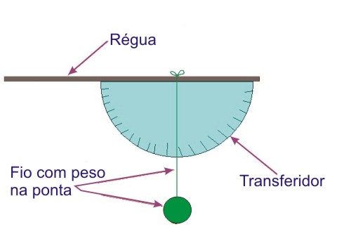
You will need a compass (I will accept a simple N, S, E or W or any variation in between) and a clinometer. There is no need to get a fancy instrument. A simple clinometer can be fashioned using a plastic protractor and a string with a weight attached.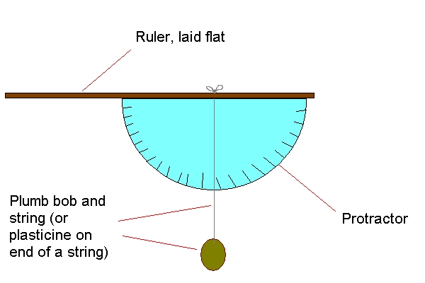
Have fun!

Sintra: 90 milhões de anos de História
De forma alongada, elíptica, orientada na direcção leste-oeste, a serra de Sintra mede apenas 10 km de comprimento por 5 km na maior largura. É, a ocidente de Lisboa, o acidente geomorfológico mais destacado existente nesta área que constitui recanto maravilhoso, não só pela beleza da paisagem, doçura e amenidade do ambiente, como pela complexidade geológica da estrutura do arcaboiço que a forma, assim como pela variedade da vegetação que a cobre.
 De origem ígnea, a edénica montanha tomou corpo nos tempos cretácicos, há mais de 90 milhões de anos quando um batólito ascendeu e perfurou os substratos do Jurássico superior. De facto, as rochas do maciço metamorfizaram e deslocaram terrenos do Jurássico superior e do Cretácico médio, pertencentes ao enquadramento do maciço eruptivo. De origem ígnea, a edénica montanha tomou corpo nos tempos cretácicos, há mais de 90 milhões de anos quando um batólito ascendeu e perfurou os substratos do Jurássico superior. De facto, as rochas do maciço metamorfizaram e deslocaram terrenos do Jurássico superior e do Cretácico médio, pertencentes ao enquadramento do maciço eruptivo.
Os altos da serra, logo que esta ficou a descoberto, foram alvo do jogo da erosão que lhe afeiçoou as formas, talhou vales apertados, esculpiu amontoados de penedos (como os amontoados caóticos graníticos da Cruz Alta, da Penha Longa, da Pedra Amarela, da Penha Verde, do Alto das Três Cruzes, etc.) e sieníticos (como os da Peninha, Adro Nunes, etc.). O festo, de perfil sinuoso, atinge alturas que não ultrapassam 530 metros.
 Sintra foi escolhida por monges e cenobitas, para localização de lugares de meditação, como o convento dos Capuchos, para poiso de palácios reais, como o da Pena, mandado construir pelo príncipe alemão D. Fernando II, marido da rainha D. Maria II (teve como arquitecto o geólogo alemão Barão d'ESCHWEGE), Paço Real ou Paço da Vila, que foi habitado por D. João I e por este acrescentado (a ele se ligam muitos factos históricos), o Palácio de Seteais, etc. Da dominação árabe restam as ruínas do castelo dos Mouros, sobranceiro à vila de Sintra. Sintra foi escolhida por monges e cenobitas, para localização de lugares de meditação, como o convento dos Capuchos, para poiso de palácios reais, como o da Pena, mandado construir pelo príncipe alemão D. Fernando II, marido da rainha D. Maria II (teve como arquitecto o geólogo alemão Barão d'ESCHWEGE), Paço Real ou Paço da Vila, que foi habitado por D. João I e por este acrescentado (a ele se ligam muitos factos históricos), o Palácio de Seteais, etc. Da dominação árabe restam as ruínas do castelo dos Mouros, sobranceiro à vila de Sintra.
Situam-se em Sintra belos jardins e parques como o Parque da Pena, instalado pelo rei D. Fernando, onde ao lado de locais encantadores, em que abundam as camélias, se encontram outras belezas, crescem maravilhosamente plantas exóticas, como a chamada “feteira da condessa” (Condessa de Edda) que relembra paisagens dos longíquos tempos do Carbónico. Sobressai neste aspecto a quinta de Monserrate, instalada pelo inglês Francis Cook, que é verdadeiro jardim botânico, onde crescem plantas das mais variadas proveniências e latitudes. São ainda de referir, as numerosas quintas e propriedades particulares, como as da Penha Verde, do Ramalhão, da Regaleira, de S. Pedro, de Penha Longa, do Marquês de VaIada, do Relógio, da Trindade, da Piedade, etc.
Estratigrafia. O que é?
A Estratigrafia é o ramo da Geologia que estuda as seqüências de camadas de rochas, buscando de terminar os processos e eventos que as formaram. A estratigrafia inclui dois subcampos, a litoestratigrafia e bioestratigrafia. 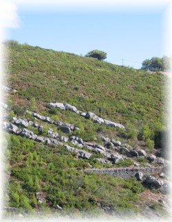 A primeira se baseia na análise das propriedades físicas e químicas das rochas; a segunda, no estudo das evidências fósseis gravadas nas rochas. A partir das descobertas nessas duas áreas, criou-se uma escala de tempo geológico, que serve de referencial temporal não só à Geologia como também à Paleontologia. A estratigrafia, que vem do latim stratum + grego graphia, é a descrição de todos os corpos rochosos que formam a crosta da Terra e sua organização em unidades mapeáveis distintas e úteis, com base em suas propriedades ou atributos intrínsecos, com vistas a estabelecer sua distribuição e relações no espaço e sua sucessão no tempo, e para interpretar a história geológica. A primeira se baseia na análise das propriedades físicas e químicas das rochas; a segunda, no estudo das evidências fósseis gravadas nas rochas. A partir das descobertas nessas duas áreas, criou-se uma escala de tempo geológico, que serve de referencial temporal não só à Geologia como também à Paleontologia. A estratigrafia, que vem do latim stratum + grego graphia, é a descrição de todos os corpos rochosos que formam a crosta da Terra e sua organização em unidades mapeáveis distintas e úteis, com base em suas propriedades ou atributos intrínsecos, com vistas a estabelecer sua distribuição e relações no espaço e sua sucessão no tempo, e para interpretar a história geológica.
Medindo a estratigrafia
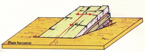
As camadas de rocha são caracterizadas medindo a sua direcção e pendor ou inclinação. A direcção de uma camada é a sua medida no plano horizontal ou a direcção da linha de intersecção da estratificação com o plano horizontal (d).
O pendor ou inclinação de uma camada é o ângulo entre a estratificação e o plano horizontal (i) e é medido no plano vertical perpendicular aos dois planos referidos.
A direcção e o pendor de uma camada constituem as suas coordenadas geológicas, referindo-se sempre em primeiro lugar a direcção e depois a inclinação (ex. N30º E, 40 S).
A earthcache
Para reivindicar esta earthcache serás confrontado com uma sequência estratigráfica perto do contacto com o granito de Sintra. Este ponto foi escolhido especificamente porque o afloramento é suficientemente grande para ser visto a 10 m de distância e não há nenhuma “complicação” geológica e podes ver os estratos em secção. A tarefa consiste em medir a direcção e o pendor (inclinação) das camadas. Mede também a espessura média das referidas camadas - estas medidas devem ser expressas emmetros ou fracções de metros.
O afloramento em questão situa-se num corte de estrada, pelo que tenhjam cuidado com o trânsito. Sugiro a observação do afloramento das coordenadas fornecidas para medirem a direcção e só depois a aproximação para medir a inclinação.
Para realizar estas tarefas vais necessitar de uma bússola e um clinómetro. Um clinómetro simples pode ser feito usando um transferidor com um pouco de fio e um peso.
Divirtam-se!

|