
 This Earthcache is located along the Bajada
interpretative trail a little way inside the Joshua Tree
National Park Boundary. There is a small parking lot and nice
metal interpretative signs along this short circle trail. The
trail is hard pack sand and is advertised as handicapped
accessible.
This Earthcache is located along the Bajada
interpretative trail a little way inside the Joshua Tree
National Park Boundary. There is a small parking lot and nice
metal interpretative signs along this short circle trail. The
trail is hard pack sand and is advertised as handicapped
accessible.
A Bajada is a group of alluvial fans that have grown together to
form one large slope of sediment at the base of mountains. Look
across the valley to the bajada that has formed at the base of the
Orocopia Mountains.
One theory about the formation of alluvial fans and bajadas has
these geomorphologial features forming in two steps beginning with
a sudden change to a more arid environment. Back in the most recent
ice age, this area was cooler and wetter. A variety of plant life
flourished in the area. This plant life anchored the soils in the
mountain ranges.
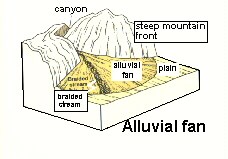 At the end of the ice age the first stage of
alluvial fan development began. The climate became more arid
causing much of the plant life to die off. This left the soil
in the mountain ranges unstable and easily eroded. What little
rain that did fall eroded the soils down through the mountain
canyons and deposited them at the base of the mountains where
the canyons left the mountain range in a fan like shape. As
these fans expanded out their edges merged together to form
the bajada.
At the end of the ice age the first stage of
alluvial fan development began. The climate became more arid
causing much of the plant life to die off. This left the soil
in the mountain ranges unstable and easily eroded. What little
rain that did fall eroded the soils down through the mountain
canyons and deposited them at the base of the mountains where
the canyons left the mountain range in a fan like shape. As
these fans expanded out their edges merged together to form
the bajada.
wrgis.wr.usgs.gov/docs/usgsnps/ deva/9ADV-2.jpg (no
longer active)
Stage 2 begins when the majority of the sediment (soil) in the
mountains has been eroded away. At this point, mountain ranges are
the predominantly rocky ridges that you see today. What little rain
that does fall in the mountains runs off quickly carrying little
sediment, thus this water has quite a bit of energy to pick up
sediment. Once that water reaches the head (top) of the alluvial
fan or bajada, it begins to erode down into the alluvial fan and
redeposit sediment at the base (bottom) forming deep channels in
the alluvial fan and extending the alluvial fan further from the
mountain range.
Logging requirements:
Send me a note with :
- The text "GCZ5Y5 Bajada – Joshua Tree NP" on the first
line
- The number of people in your group.
- Look at this side of the valley. Is this side of the valley
qualifies as a bajada? Include your reasoning.
The following sources were used to generate this
cache:
- Trent, D.D. & Richard W.
Hazlett, Joshua Tree National Park Geology, Joshua Tree National
Park Association, 2002
-
http://www2.mcdaniel.edu/Biology/wildamerica/desert/desertgeolgy.html
- wrgis.wr.usgs.gov/docs/usgsnps/ deva/9ADV-2.jpg
(no longer active)
Placement approved by the
Joshua Tree National Park