Congratulations to the Kootenay Pirates who were the First to Find - winning themselves an IDTimberwolf geocoin.
This is a 3 stage multicache adventure that takes place near the following cities; Rossland, New Denver and Salmo, all of which are located in the southwest Kootenays of beautiful British Columbia. The first stage will take you to an old fire lookout, next, you will venture underground into an abandoned mine tunnel, and finally you will ascend a short trail to a beautiful alpine lake. Sounds easy – but the fire lookout is atop Old Glory (about a 6-7 hour return hike up and down a mountain), also, the first part of the mine tunnel is submerged in over a foot of water, and finally, the trailhead to the alpine lake is only accessible by a motorbike, quad or high clearance 4X4 with an owner who doesn't care about the vehicles paint job.
There is no physical cache at the first two stages – instead you will find partial co-ordinates to the final cache. On top of Old Glory Mountain you will find the longitude, and in the mine tunnel you will find the latitude for the final stage.
* * The final cache contains an added bonus – inside the logbook are co-ordinates that will take you for a short hike to a bonus destination * *
STAGE #1
N49° 08.989 W117° 54.730
For parking directions see Magic School Bus or Old Glory Mtn– these are 2 caches located along the trail to Old Glory. There is an old lookout atop the summit at 2376 meters in elevation. The partial co-ordinates you’re looking for can be found inside this fire lookout, they are written in yellow and can be located under the table or inside the oven.

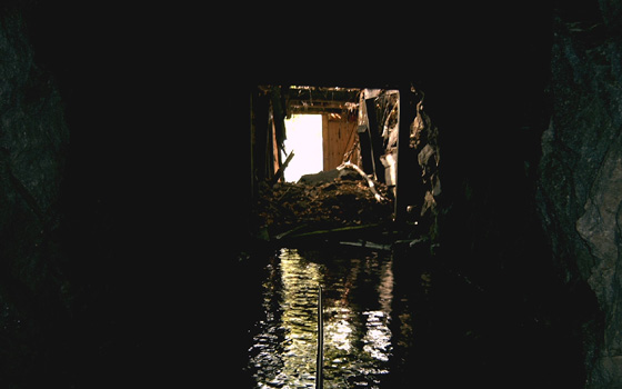
STAGE #2
N50° 00.255 W117° 22.836
This mine tunnel is located along the shore of Slocan Lake, so you can access this by boat (although it’s a rocky shoreline and I wouldn’t recommend it for a large craft), or you can follow a good trail for about 1km in towards the mine entrance. To reach this trail, park at Bigelow Bay Regional Park which is located at the VERY end of Kildare Street in New Denver at N49° 59.826 W117° 22.318. The trail is an old railway bed – follow it up the lake, then at N50° 00.238 W117° 22.779 turn off the main trail and follow the seldom used path down to the abandoned mine.
You will need a flashlight or two, also, I’d recommend high rubber boots because the first few yards of the tunnel is filled with cold water over a foot deep. To reach the clue you will need to follow the ore cart tracks into the mine and keep to the left for about 150 paces. This will take you to a tunnel that once had a wooden partition blocking the passage. The door is gone but the wooden framing is still there, and up on the wooden door header is a rock with the partial co-ordinates painted on it. DO NOT remove the rock – please put it back in the same spot for the next geocacher to find. While in the tunnel keep an eye out for ghosts of miners past.
If you look in past the wooden partition into the room and up on the ceiling you will see the beginning stages of stalactites. These tiny stalactites have taken almost 100 years to grow and are very rare. Please do not disturb them.
FINAL STAGE
You must have retrieved both halves of the co-ordinates from the first 2 stages to find the final cache up by picturesque Wulf Lake (Waldie Lake on some maps). To get there follow Airport Road south from the city of Salmo for a little over 5km and turn onto Sheep Creek Forest Service Road. Continue along the FSR for 10km following the creek all the way and then cross over the creek on a concrete bridge at N49° 07.400 W117° 04.630. From here it’s about 6km to the trailhead and parking area. Cross a second bridge and keep to the left, the first couple hundred meters are very rocky as you drive past some mining ruins on your right. The road gets better except for a couple of “ditches” you’ll have to negotiate your quad through. The trailhead is at N49° 07.400 W117° 04.639 and the parking area is about 50 meters further up the road. The trail leading up to the cache is less than 1.5km. Use the co-ordinates found from the first 2 stages to find the final cache. Remember to look in the logbook for co-ordinates that will take you for a short hike to an added attraction.
Whoever completes this adventure will receive a Zanadian tag
Enjoy your adventure!!!