Hiker's Delight Mystery Cache
-
Difficulty:
-

-
Terrain:
-
Size:  (regular)
Please note Use of geocaching.com services is subject to the terms and conditions
in our disclaimer.
This cache is for those who like a good hike! Keep an eye on the
regulations in the area, you are very close to the Commanche Peak
Wilderness. THE CACHE IS NOT IN THE WILDERNESS
AREA.
Knowledge of How to use UTM's and Maps & Compasses are essential components of
this cache.
Footnotes on Compasses:
When using a compass in the field, it is very important to be
careful when taking the measurement and when converting between
field and map bearings. An error of five degrees in reading
accuracy will result in a position error of about 150 yards after
one mile of travel.
East Declination: The declination is East (9.5°). You need to make
the two worlds equivalent by adding or subtracting the
declination.
- Map Bearing to Magnetic Bearing: If you are taking a
bearing from one point on your map to another point on the map with
respect to true north, then you are working with the map bearing.
Now you want to figure out where your position is in the magnetic
bearing. In order to transfer this information back to your
magnetic bearing you need to subtract the declination from your map
bearing compass bearing to create the proper magnetic bearing
bearing. Map bearing - Declination = Magnetic Bearing.
- Magnetic Bearing to Map Bearing: If you use your compass
to take a bearing from your current position to a point on the
landscape, then you are working with the magnetic bearing. Now you
want to figure out where your position is on the map. In order to
transfer this information back to your map you need to add the
declination from your magnetic bearing compass bearing to create
the proper map bearing. Magnetic bearing + Declination = Map
Bearing.
This particular compass is especially helpful while using
UTM.
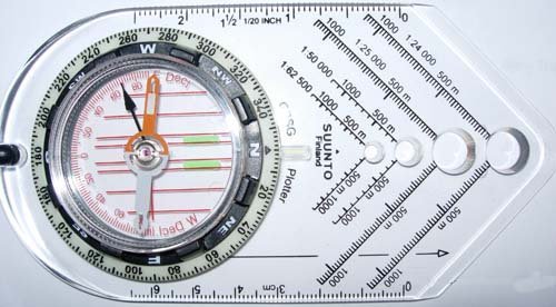
This is Suunto's GPSG Plotter compass.
Brunton's 8096 GPS Compass is also a very good
compass.
Be prepared for a good hike to get to this cache. And bring plenty
of water! This is a completly dry trail and has a southerly facing
slope, so on the 95 degree days you can run out of water fast.
This trail does flirt with the wilderness boundary, keep an eye
on where you are for what regulations you should be following. Two
good maps to use are Nat Geo's #101 (big thompson) and #200 (RMNP).
Both show the wilderness boundary.
The FTF gets a prize of six bucks. Original contents were 16
triangular pencils, 2 wooden rulers, 1 clip on pencil
sharpener/eraser combo, 1 hot wheels 2004 Maserati Quattroporte, 1
60 count bandaid box, logbook and pen. Cache is a 50 cal ammo
container with "Official Geocache" sticker on the side.
The main listing coordinate for this
cache IS NOT WHERE THE CACHE IS.
To find this cache some real land navigation skills are a must.
This is some rugged country that skirts the northern edge of the
commanche peak wilderness area.
Okay here we go: There once was a cacher named
JR.
He liked to Hike with a purpose. On this particular rainy
August day,
he ended up wandering around the North West corner of the Glen
Haven 7.5 min map.
When he stopped to shoot bearings with his declination adjusted
compass
he found that he was
60 MAP degrees to X9073,
344.5 MAP degrees to X9945,
and 310.5 MAP degrees to the center of the 10890 foot tall
mountain labeled Bulwark Ridge.
The map had what appeared to be a flat spot on the mountainside
so he stopped to fill out part of his hike report and have a
snack.
Find where he took a break and you'll find the hiker's delight!
HAVE FUN AND BE SAFE!!
FTF: Denali41, 9-12-2006 -
Congratulations!
Additional Hints
(Decrypt)
Lbh ernyyl arrq uvagf??? Bxnl svar, ybbx ng gur cvpgherf gung V cbfgrq. (qbhoyr purpx gur jbeqvat V hfrq sbe gur pbzcnff jbex!)