
Nonsuch Park occupies the site of one of Britian’s
architectural jewels. The only problem is that the jewel was
demolished over 300 years ago leaving barely a trace. In solving
the clues you will explore a 450 year old Royal Palace called
“Nonsuch” for as one contemporary wrote “there is
not its equal in England”.
Henry VIII ordered the construction of Nonsuch to mark his
30th year on the throne, and the palace was all but
complete by his death. The Palace was built to be a sumptuous
stopping off point on Henry’s hunting trips. A place where he
could entertain, rest, and play games with foreign dignitaries, his
friends and his children. The palace was part of a network of
hunting lodges, major palaces and hunting parks which ranged in an
arc from Kew, Richmond, Hampton Court, Nonsuch, to Oatlands near
Weybridge, and Windsor.
Waypoint 0 - Information Board - N51 21.342 W000 14.357 - A
good place to start your exploration of Nonsuch Palace.
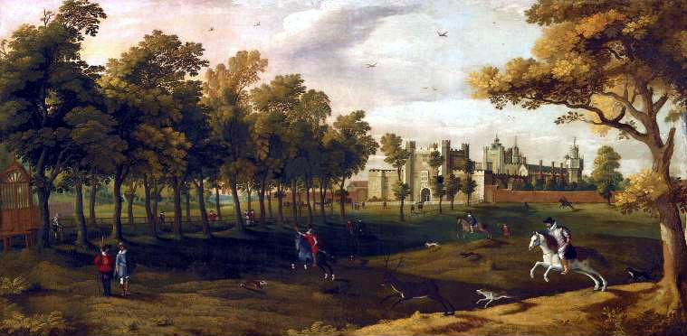
The picture above shows you what you would have seen in the late
16th century as you walk from the recommended parking
towards the first waypoint. You are approaching the main entrance
to the palace by crossing the handsome bowling green set out with
seating and railings.
Waypoint 1 - The Gatehouse - N51 21.274 W000 14.325 - There
are four dates on the plaque. A = the second digit of the first
date, and B = the third digit of the last date.
You are now at a pillar marking the entrance to the Palace. A
map on the pillar will allow you to get your bearings. The
gatehouse was a large crenelated building nearly 60 feet across and
three stories high with towers at the corners. Passing through the
Gatehouse leads you to an enclosed courtyard surrounded by two
story high buildings. These were occupied by the officers and staff
of the palace and were built of stone and brick. Much of the stone
was robbed from Merton Priory which was dissolved in the year
construction of Nonsuch started. On your left beyond the buildings
surrounding the courtyard were the various kitchen buildings.
Waypoint 2 – The Outer Court - N51 21.264 W000
14.323
Ahead of you, marked by the second pillar is a gatehouse leading
to the Inner Court. This Inner Gatehouse had a gateway reached by
climbing eight steps. It was crenelated like the outer gatehouse,
but highly decorated including, for example the statues of three
Roman Emperors adorned its front. As well as having corner towers,
there was also a central clock tower with a large gilded clock with
brightly painted hands.
Waypoint 3 – The Inner Court - N51 21.326 W000
14.306
Passing the second pillar, you are now entering the Inner Court,
the true glory of this remarkable palace which stretched to the
back of the Palace, marked by the third pillar. The Inner Court was
highly decorated. Around all four sides the three story tall
buildings were covered in rows of highly decorated plaster panels
illustrating scenes from classical myth, floral motifs, and various
insignia. There were also carved slate panels. The exterior of the
Inner Court buildings were also decorated, including depictions of
various beasts, both real and fanciful. In the centre of the
courtyard was an ornate marble fountain decorated with large gilded
figures of mythical beasts.
The buildings on your left were the Queen’s Apartments,
and the King’s were to the right. The fantastic decoration
was carried throughout the buildings. At the rear corners of the
palace were two large octagonal towers which were five stories
tall.
Waypoint 4 - The Privy Garden - N51 21.185 W000 14.269 - C is
the number on the pillar
From the third pillar to here, and extending on every side were
the formal gardens, laid out, probably in an Italianate style. The
gardens included various statues and fountains, and two stone
pyramids.
Waypoint 5 - The Wilderness and Orchard - N51 21.151 W000
14.376
This part of the grounds of the palace was known as the
Wilderness. It was not a wild area as it is now, but instead was an
area with tree-lined paths and walks laid out amongst a variety of
trees, native, exotic and including fruit trees. Areas of trees
were marked out with wooden panels to make games courts for the
playing of games like tennis, and seating and pavilions were laid
out for people to view the entertainments. The rector of Cheam
writing in 1581 describes a remarkable menagerie in the Wilderness
with crocodiles, snakes, panthers and tigers and an aviary.
Waypoint 6 - The Grove of Diana - N51 21.140 W000
14.483
The path to the right leads to the grove of Diana. This was an
opening in the woods with a pool fed by a natural spring,
surrounded by statues of Diana and her nymphs. Nothing remains
now.
Waypoint 7 - The Banqueting House - N51 21.115 W000 14.583 -
D = the number painted on the tree. If you see two numbers, ignore
the number written in red.
In Henry VIII’s time a banquet was a light meal of
sweetmeats served whilst being entertained. The raised platform is
now retained by a brick wall but was originally retained by stone,
the platform was paved to accommodate outdoor dining and
entertainment. The banqueting house itself was a 44 foot by 38 foot
building occupying the centre of the platform.
Now you have the final coordinates you can retrace your steps
and explore a small part of Henry VIII’s enormous hunting
estate to reach the cache. Which can be found at
N51 21.[C-1][A][C+A] W000 13.[C+B][A-B][D]
You can check your answers on
Geochecker.com.
Note that on the way to the cache location, depending on the
time of the year, you may pass signs warning you of the need to
take care due to ground nesting birds or other wildlife or
environmental reasons. For example, dogs may need to be kept to
paths or other restrictions may be applied. Please comply with
any instructions.
As you will have seen, very little sign remains of Nonsuch
Palace. It was demolished in 1682 so that Barbara Villers, a
mistress of Charles II, could sell the second hand building
materials. It is difficult to see anything of the palace on the
site. Various artefacts can be seen at Bourne Hall Ewell, Honeywood
House Carshalton, and The Whitehall Cheam. For more information, an
excellent book on the palace, The Search for Nonsuch by John Dent
is available from Sutton Library and is amazingly good value at
only £2.50.