Rozstipena skala
[CZ]
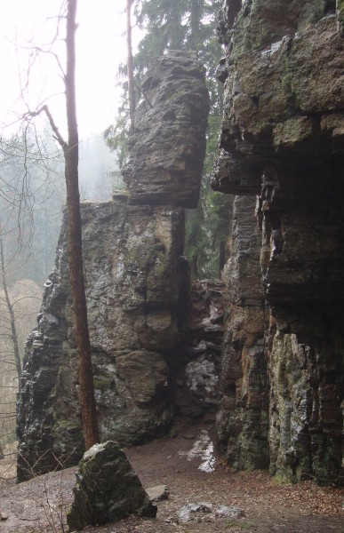
Cache Vas privede k jednomu z mnoha zajimavych skalnich utvaru na rece Sazave. Prirodni pamatka byla vyhlasena v r. 1974. Mrazovy srub, tvoreny biotickou ortorulou, je rozdelen puklinou sirokou 2m. Puklinou vede turisticka cesta, Podle nekterych dohadu se skala roztrhla pri zemetreseni v srpnu 1328, kdy byly zniceny stribrne doly na nedalekem Peperku. Nejvyssim bodem je Jehla, vrcholovym skaliskem je Kazatelna. Skalu vyuzivaji horolezci. Na svazich roste sutovy les a vyskytuje se tu mj. Mesicnice vytrvala.
Skala je pristupna po cervene nebo zlute turisticke znacce. Pri vyssim stavu vody je od Najdku mustek pod skalou zatopen, tak doporucuji jit po silnici smerem na Slakhamry a tesne pred podjezdem pod zeleznici zatocit po pesine po pravem brehu Sazavy (zde je možno zaparkovat) a zde pokracovat az ke skale. Doporucuji ješte dojit az na horni konec vesnice Slakhamry, zde je Konec sveta, který je strazen lesnim muzem.
Pri hledani cache nemusus chodit az k hrane skaly, je to cache turisticka a ne horolezecka.
Ale zalezi na Vas, jaky zvolite teren, je mozny od T1,5 (ve smeru od SZ) do T5 (ve smeru od JV).
[EN]
This cache shows you an interesting rock formation close to river "Sazava". That nature memory was declared in 1974. Rock is divided by a crevice which is 2m wide. Trough the crevice goes a tourist path. The history says that the rock was torn during a earthquake in august 1328, when the silver mines in Peperek were destroyed. The highest point is "Jehla", the top of rock is called "Kazatelna" ("Pulpit"). The mountaineers use that rock. On the slopes grow the original forest.
To the rock you can go along yellow or red tourist sign. If there is a lot of water in river, the small bridge under rock is flooded (In the direction from "Najdek"). So it is better to go on street in direction to "Slakhamry" and close before the railway underpass turn to path on the right bank of river "Sazava" (you can park here). Now continue to the rock. I recommend you to go to the upper part of village "Slakhamry". There is a place called "the end of the world", with is guarded by the "wood-man"
During looking for the cache you do not have to go to a edge of rock. It is the tourist cache not the cache for the mountaineers.