The stages of this cache are within 1 mile of each other on flat terrain so it is quite doable as a longer walk, easy bike ride, or by motorized vehicle.
I apologize about the long description, but this was originally intended to be 3 separate virtual caches. (To skip the details and work the cache only, you can jump directly to the 3 headings marked by *** below.)
Stage 1, “Villa Louis Artesian Fountain”. (The listing coordinates get you to the gate entrance in the garden, less than 100 feet away from the easily visible fountain just to the Northeast.)
This artesian fountain is on the grounds of the historic Villa Louis mansion on St. Feriole Island. It was named after H. Louis Dousman, the second of three generations of Dousman families to make this their summer home since the 1840’s. The present house was built in 1870 by Louis. Shortly after, a 375 foot deep artesian well was drilled to create a refreshing fountain and provide water for a large fishpond. The artesian water is full of minerals, and the Dousmans believed the water was healthy. A large tank in the house’s upper story was filled with the water which was then piped throughout the house and fed by gravity for drinking, bathing, and watering their famous trotting horses that they bred on the grounds. (Click here to see an artist rendering of the property in 1884 when it was a horse-breeding farm and was named the “Artesian Stock Farm”.) In 1952, the property became Wisconsin’s first State Historic Site. It is now also a National Historic Landmark and is listed on the National Register of Historic Places.
Admission to the Villa Louis grounds is required beyond the entrance gate. Interesting tours are conducted daily from May to October and are highly recommended. If you are there only as a step toward completing this cache and viewing the artesian fountain, the garden preceding the gate is free to the public. It is a peaceful area overlooking the duck/fish pond which is fed by the artesian well. The garden is equipped with walking bridges and benches and is home to various wildlife, many ornamental flowers and shrubs, and several graceful trees.
***Determining the final stage North coordinate: ( N 43° 0@.#$%’ ) There is a message written on the garden gate located at the listing coordinates. The first letter of each of the first 4 words are required to determine the North coordinate for the final/3rd stage. The North coordinate for the final/3rd stage of this multicache is N 43° 0@.#$%’ where the values for @, #, $, and % can be determined by using the following simple alphabet-to-number conversion:
A=0, B=5, D=8, F=1, L=0, R=2, S=9, T=3, V=7 and W=4
where @ is the number corresponding to the first letter of the first word, # is the number corresponding to the first letter of the second word, etc.
(For example, if the message on the gate were “Don’t Feed the Bears”, the first letters of the first 4 words would be D,F,T,B which correspond to the numbers 8,1,3,5 for @,#,$,% so the North coordinate for the final/3rd stage would be N 43° 08.135’.)
Previous Stage 2, “The Great Artesian Fountain”. (You do not need to visit this location as the well is no longer there as of Summer 2018 due to a library addition.)
This well was completed in February 1876 with a bore of 5-5/8 inches and a depth of 960 feet. The initial fountain shot water nearly 1,000 feet in the air and later settled down to 60 feet. The well can discharge 604 gallons of 56°F water per minute. At the time, this artesian well produced the largest flow in America and the second largest in the entire world. The well paved the way for the development of a sanitarium industry in the city since the water was mineral-rich and thought to possess rare medicinal properties. In 1907 the city purchased the property and turned it into the Artesian Park. (Click here to see a postcard photo of the fountain during that era.)
Today, the Wachute Memorial Public Library rests on most of the former park grounds. Unfortunately, the fountain was permanently capped in late 2017 due to an addition on the library that exposed structural problems with the well casing. In the 1960’s the well had been connected to a nearby drinking fountain, but due to city liability, the drinking fountain has been removed and drinking not recommended because the water was not chlorinated or regularly tested.
Final Stage, “The Prairie du Chien Artesian Well Flouring Mill”. (The north coordinate is determined from information collected from stage 1. See above. N 43° 0@.#$%’ W 091° 09.000’ )
In 1855, Henry Weniger initially built and operated a traditional stream water-fed flouring mill in nearby Eastman. Following several years of reduced production due to low water flow during droughts and ultimately in 1869 a flood wiping out the dam and much of his mill, he sought a more reliable method for producing power for a mill. Since other powerful artesian wells had recently been drilled in the Prairie du Chien area, he conceived an idea to harness this natural upward force of water to run a mill. The best mechanics told him it wasn’t possible, but he proved them wrong, and by 1878 he had built a mill powered by the water flow from 3 artesian wells. Mr. Weniger was a true innovator since this was the first (and at the time, the only) mill in the world that derived its power from the upward flow of water from the earth. Shortly after, many others followed suit resulting in several similar artesian powered mills being built worldwide.
Initially two wells were drilled 1,044 feet deep with bores of 6 and 8 inches, followed shortly by a third. Two of the wells provided power for the actual grinding of the grain. The third well powered belts, elevators, and fans to perform other functions necessary for the mill operation. The mill building measured 45x60 feet with two stories, had two runs of grinding stones, and produced at a capacity of 100 bushels per day. The mill was closed in the 1930’s. (Click here to see a photo of the original mill.)
Today, the mill building and equipment have been removed, but the artesian wells still flow strongly. The mill site is private property and the owner has used some of the original stones to build a beautiful patio surrounding the wells. Two of the wells near the patio are obvious while the third one is less visible much closer to the river. The well water flows into a slough that feeds into the nearby river. Because the water from the wells is always warmer than 32°F, it keeps the water in this area open throughout even the coldest winters. The open wintertime water often attracts bald eagles which fish the area and perch in the surrounding trees.
***Important!!!:
The container is accessible by walking a closed alley which passes just north of the 3 artesian wells. The best place to park is on the paved portion of this alley directly East of the cache location. Please DO NOT drive (only walk) beyond the barricades and DO NOT play in the water. The wells themselves are on private property but are quite visible from the alley. Please respect the “No Trespassing” signs and DO NOT loiter in the neighbors’ yards. The man living in the house just north of the wells maintains the alley’s lawn and has given permission to place and access this cache. If you see him (his name is Roger), thank him for allowing this geocache in his neighborhood.
***The cache: The cache is a regular-sized water-tight container and contains a logbook, pencil, and some nice starting trade items. Make sure to screw the lid securely before leaving since flooding could occasionally be possible in this area. Please return the container to its hiding spot as found. Also, please do not post pictures which show the information on the gate or signs at the first stage.
If you like historical/interesting sites like this, you may also want to check out my “Meteorite or Meteor-wrong?” cache (which was placed at the same time) while you are in the PDC, WI area. If you are specifically interested in artesian wells, you might want to check out my "Paradise Cove & Artesian Well" cache in Winslow, IL.
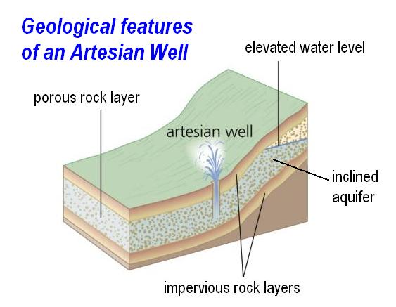
How an Artesian well works: (See below image.)
An artesian well is a drilled well that results in water flowing to the surface without the need for a pump. Such a well taps into an underground inclined aquifer (layer of porous rock capable of holding and transmitting water) which is sandwiched between two impervious rock layers. The internal pressure is a result of the weight of water in a portion of the aquifer which is at a higher elevation than the well head pushing down through the aquifer. The greater the internal elevation difference, the greater the artesian well’s pressure and height of its fountain. Water from artesian wells are usually cold and free of organic contaminants often making it desirable for drinking.
Additional Hints:
Uvqqra haqre n cvyr bs ebpxf.