I had heard lots of stories about how beautiful the Walls of
Jericho is, but I had never been there. Well let me just tell you,
words cannot do justice to this incredible natural area, you just
have to see it for yourself, so I placed a cache here to give you
an added incentive.
In the late 1700s, Davy Crockett first explored the area since
his family owned this land. In the lates 1800's a traveling
minister came upon the Walls of Jericho and was so captivated by
the cathedral-like beauty that he declared it needed a biblical
name and the name stuck. You can travel to the bottom of its
50-yard-wide limestone bowl and look up at 200-foot-tall cliffs on
each side. In a heavy rain, water shoots out of holes and cracks in
the rock, but I sure would not want to be here during heavy rain.
Make sure you go all the way to the end of the trail and check out
the "cathedral" from both ends. While standing in the bowl you will
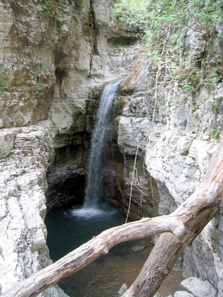
see a stream coming out of a cave and cascading down to a small
waterfall. If you will do a little climbing and proceed on up the
canyon you will find where that water is coming from. There is a
waterfall that comes over the rim and drops fifty feet or so into a
beautiful little grotto, which is where Scoot and I had our
lunch.
Of course the cache is hidden downstream in a spot that should
keep it safe from prying eyes and rising waters. GPS reception at
the bottom of the gorge is spotty at best, so I took an extra long
time averaging the coordinates, then hiking out aways and back to
recheck them. After my gps settled down the coords were pretty
close to dead on, but it took it a while to settle down, when I
first walked up to the big rock the cache is under my gps said I
was 43 feet away, but as I stood there it took it less than a
minute to come down to less than ten feet. I am sorry, but I think
this is as good as it gets under tree cover at the bottom of a
narrow canyon. Just be patient and the coords will settle in. That
was the bad news, now here is the good news, I am going to do my
best to tell you where to look. If you make the walk, I want you to
find the cache, the beauty of the area is the true reward for this
smiley. I rated it a 3.5 difficulty based on the poor signal
reception and the fact that the cache is not in plain sight. The
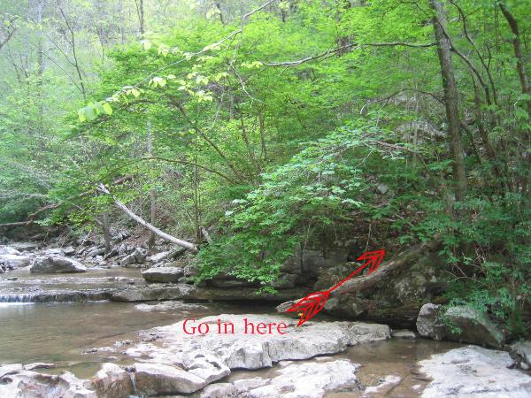
cache is on the northeast side of the stream, below the bowl, just
above the last big fall line. It is about thirty feet uphill from
the stream under the highest of three boulders that are piled
together. The cache is a clear lock-n-lock container under a couple
of rocks. This picture should show you where to go in, just above
the log.
This area is managed by the Tennessee Wildlife Resources Agency
and is open to the public. In addition to the hiking trails, there
is a horse trail that leads to the point where Turkey Creek and
Hurricane Creek meet, at that point you have to leave the horses
and hike the last mile into the canyon, but I am sure that it would
be a nice ride. While hiking you will cross the horse trail a
couple of times. At the meeting of the creeks there is a meadow
that is open for tent camping if you decide to make this an
overnight adventure. The meadow is adjacent to Clarke Cemetery and
is sort of the hub of the trails, in that all of the different
routes leading to the Walls of Jericho terminate here and join into
a single trail that leads up the canyon. Speaking of trail choices,
if you hike in from the trailhead coordinates I am posting you will
only have one decision to make on the way in. There is a fork in
the trail with a sign that points to the footbridge on the right
fork. The path to the footbridge is longer, but will lead you to an
easy crossing on a really neat log bridge across hurricane creek.
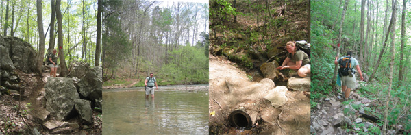
If you take the left fork it is a fairly short walk down to the
creek, but then you have to wade across, when we were there it was
less than knee deep, but I am sure it would be impassable after a
heavy rain. The kicker is that if you take the footbridge path, you
will still have to cross Turkey Creek, but it is more of a rock
hopping exercise than a wade. We opted to wade the creek on the way
in and to use the footbridge on the way out. Check out these shots
that will give you a feel of what you are in for on the trails.
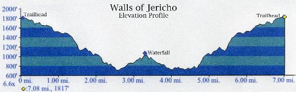
The hike is about 7 miles in length, roundtrip, and is downhill
most of the route into the gorge. That, of course, means the walk
back will be mostly uphill. It is a strenuous hike, so you should
wear comfortable shoes and take plenty of water and snacks. The
trail is well marked but often is muddy for days after a rain
shower. Several streams have to be crossed, so plan on getting wet.
Be advised that stream levels rise quickly during thunderstorms and
crossing them can be hazardous in swift water. Plan on a minimum of
six to seven hours to make the round trip, which includes a
two-hour stay in the gorge. If you want an idea of what kind of
elevation change I am talking about just check out this profile.
This is from our gps track going in taking the left fork and wading
and coming out over the footbridge.
Just a couple of more quick notes, the trailhead and parking for
hikers are actually in Alabama about a mile south of the border at
N 34 58.620 W 86 04.820, parking for horse trailers is about a mile
further south. There is plenty of parking available at the
trailhead. There was something cool about hiking from one state to
another, I know that it is no big deal but I thought it was cool.
While driving in from Tennessee we passed a new TWRA Walls of
Jericho Trailhead on the Tennessee side of the border, but I did
not have a trail map for that one so we went with what we knew, the
next time I am down I will try that trail and let you know if it is
finished. Be sure to take your time and look around while you are
hiking in and out. There are all kind of cool things along the
trail including a very cool hollow log stream crossing, several
caves and all kinds of wildlife. I was amazed at how quickly the
environment changed from old growth forest, to underbrush to karst
to boulder fields to stream and meadow and back again. Although I
was dog tired at the end of the day, the views are well worth the
hike, I hope you enjoy the Walls of Jericho as much as I did, I
look forward to seeing you on the trails.