DANSK:
Lokationen:
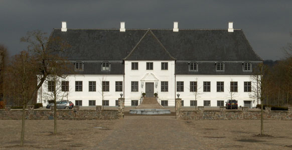
Constantinsborg er en herregård, der kendes fra historiske
kilder fra omkring år 1400 som Stadsgård, men er formentlig noget
ældre. Den ligger i et naturskønt område vest for Århus ved den
nyoprettede Årslev Engsø. I slutningen af 1600-tallet lod den
daværende ejer baron Constantin Marselis godset omdøbe og ombygge
som et symmetrisk barokt anlæg, der var højeste mode dengang.
Symmetrien ses stadigvæk, hvis man kommer fra syd ad Alleen, der er
en vej, som fortsætter over gårdspladsen til hovedbygningen. Den
nuværende hovedbygning blev opført i 1802 efter en brand året før.
I 1867 overtog Hendrik Pontoppidan godset og igangsatte omfattende
ombygninger, herunder opførelse af de nuværende avlsbygningerne,
der er bygget i kampesten. Constantinsborg var i
Pontoppidan-slægtens eje indtil 1999, hvor Troels Holch Povlsen
overtog godset og startede en omfattende restaurering.
Constantinsborg er ikke åben for offentligheden, men der er gode
muligheder for gåture i området omkring. Jagten på denne cache vil
bringe dig rundt på en lille del af det sti-system, der omgiver
Årslev Engsø og Brabrand Sø. Fra cachen er der udsigt til
Constantinsborg og ud over Årslev Engsø.
Cachen:
Der kan parkeres på pladsen ved WP1.
WP1: Ved N 56° 08.200 E 010° 04.432 finder du en stolpe, hvor
stien mod øst starter fra parkeringspladsen. På vestsiden af
stolpen er der 4 skilte.
A er det samlede antal dyr (ikke
mennesker) på skiltene.
E er antallet af grønne skilte
F er tallet på 3. skilt minus antallet
af skilte
Følg stien mod øst. Ved vejen (Alleen) drejes mod nord mod
Constantinsborg.
WP2: Ved N 56° 08.291 E 010° 04.615 står du for enden af Alleen
ved indkørslen til Constantinsborg. På gavlen af de nærmeste
bygninger kan du se et årstal VXYZ.
B er V +
Y.
C er V +
Z.
D er V +
X.
Tilbage til stien og fortsæt mod øst. Cachen findes på N 56°
08.ABC E 010° 04.DEF.
ENGLISH:

Location:
The manor Constantinsborg is known from historic records from
around 1400 as Stadsgaard but is probably older. It is located in a
beautiful area west of Århus at the new lake Årslev Engsø. In the
end of the 17th century the owner baron Constantin Marselis renamed
and rebuild the manor in the then highly modern baroque style with
strictly symmetric buildings, roads and gardens. The symmetry is
still visible when arriving from the south. The present manor-house
is build in 1802 after a fire the year before. In 1867 Hendrik
Pontoppidan became owner and started massive rebuilding including
the present surrounding buildings. Constantinsborg were the
property of the Pontoppidan family until 1999 where Troels Holch
Povlsen became owner and started major restoration.
Constantinsborg is not open for public, but the surrounding area
offers good opportunities for a walk. During the hunt for this
cache you will travel a small part of the public paths around
Årslev Engsø and Brabrand Sø. From the cache there is a view to
Constantinsborg and Årslev Engsø.
The Cache:
Park at WP1.
WP1: At N 56° 08.200 E 010° 04.432 you'll find a pole where a
path leads east from the parking area. There are 4 small signs on
the west side of the pole.
A is the number of animals (not
humans) on the signs.
E is the number of green signs.
F is the number on 3rd sign minus the
number of small signs.
Follow the path east. Turn left/north at the road (Alleen) to
Constantinsborg.
WP2: At N 56° 08.291 E 010° 04.615 you are at the entrance to
Constantinsborg. On the buildings nearby you see an number
VXYZ (the year of construction).
B is V +
Y.
C is V +
Z.
D is V +
X.
Go back to the path and continue east. The cache is located at N
56° 08.ABC E 010°
04.DEF.