Alentejo
is a south-central region
of Portugal. Its name's origin, "além do Tejo", literally
translates to "beyond the Tagus". The region is separated from the
rest of Portugal by the Tagus river, and extends to the south where
it borders the Algarve. There are four sub-regions; the Alto (High)
Alentejo, the Baixo (Lower) Alentejo, the Alentejo Central, and the
Alentejo Litoral. Its main cities are Évora (the region's capital),
Portalegre, Beja, and Sines. It has 776585 inhabitants (2001), and
an area of about 31152 km².
The area is commonly
known as the "bread basket" of Portugal, a region of vast open
countryside with undulating plains and rich fertile soil. With very
few exceptions all the major towns are mainly reliant on
agriculture, livestock and wood.
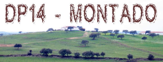
"Montado" is the term given to the typical
Alentejo scenery with its low undulating plains and sparse,
scattered trees.
The
cache:
This cache was for a while, in the womb of another cache namely,
"em busca das nascentes do Sado", which was
designed to carry in it another five microcaches for the
visitors who wished to take one to hide it elsewhere in the
Alentejo region to promote the population of caches in this
region. As a result of such a visit, this cache can be regarded
as the daughter cache and now lies hidden within the Castro
Verde County near Santa Bárbara dos Padrões.
The cache will provide you with a unhindered panoramic view of the
Alentejo plain that is well worth the trip. Also when you are
there, listen to the sounds of silence.
The
cache is hidden on the WNW side of a stone beacon at the top of a
hill. You will do well to see and take the
spoiler image
with you so you don't tear the whole thing apart. Please
remember to PRESERVE other people's property, i.e. LEAVE NO
TRACE.
Please take note of
the following:
- You have to
WALK to the cache (do not drive/ride to the
cache!)
- Car to cache will take you no more than 2 minutes (It's 195 m
from car to cache)
- Entrance at N37º 38, 575 W 7º 58,269.
- If you find the gate open, then leave it so. However, if it is
closed then close it after you when you go for the cache and once
again when you leave.There may be livestock around that will wonder
on to the road. You don't know how expensive sheep and pigs are
until you get the bill.
Happy hunting!
A Região do Alentejo é
uma região portuguesa, que compreende integralmente os distritos de
Portalegre, Évora e Beja, e as metades sul dos distritos de Setúbal
e de Santarém. Limita a norte com a Região Centro e com a Região de
Lisboa, a leste com a Espanha, a sul com o Algarve e a oeste com o
Oceano Atlântico e a Região de Lisboa. Área: 31152 km² (33% do
Continente). População (2001): 776585 (8% do
Continente).
Falamos
de Alentejo quando falamos de Montado. Vasta zona
que verdeja à sombra ora de azinheiras ora de sobreiros, onde o
gado pastoreia livremente.
A
cache:
Esta cache esteve durante uns
tempos no ventre de uma outra cache entitulada
"Em busca das nascentes do Sado" que foi
formulada para levar cinco microcaches para depois de encontrada
serem escondidas na região do Alentejo cuja população de caches
ainda é deficitária. Portanto esta cache é uma das filhas e que
agora está escondida no Município de Castro Verde perto de Santa
Bárbara dos Padrões.
A cache proporciona uma bela vista da planície Alentejana e qundo
lá estiverem, ouçam bem o som do silêncio.
A cache reside num marco de
pedras no topo de um pequeno monte. Para não destruírem o marco é
melhor levar a
spoiler image
quando forem procurar es ta cache. Lembrem-se de não danificar
propriedade alheia ou seja, NÃO DEIXEM RASTO.
Atenção ao seguinte:
- Têm de ir a PÉ até à cache (De maneira nehuma
vão de mota/bicicleta ou 4x4)
- O tempo do carro à cache deve rondar os 2 minutos (são 195 m do
carro à cache).
- Entrada em N37º 38, 575 W 7º 58,269.
- De maneira nenhuma deixem o portão aberto quando forem à cache ou
quando se ausentarem da zona. Existem muitos animais que certamente
irão parar à estrada. Se acham que as costeletas e as febras estão
caras, esperem até ter que pagar a ovelha ou porco
inteiro.
Boas caçadas!
___________________________________________