abies alba Multi-cache
-
Difficulty:
-

-
Terrain:
-
Size:  (small)
Please note Use of geocaching.com services is subject to the terms and conditions
in our disclaimer.
Geänderte Beschreibung & neues Final seit 2020-06-14
 |

|
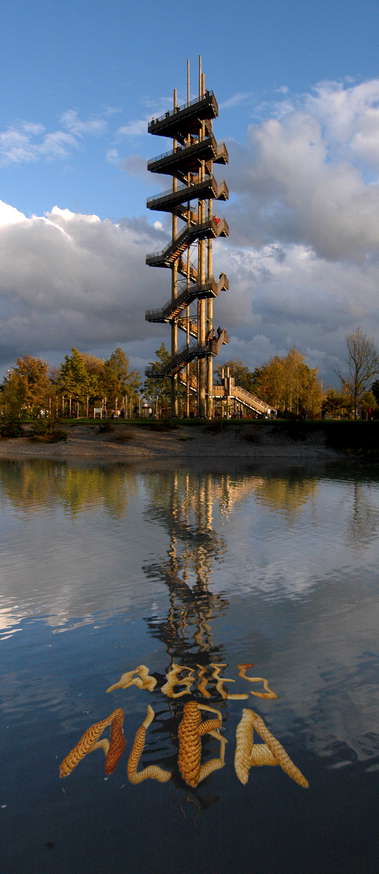
Seit September 2003 erhebt sich am südlichen Altrhein bei N 48°33.923 E007°48.568 mit 44m der höchste Holzturm im Schwarzwald.
Ihr solltet Euch die Zeit nehmen und die 210 Weißtannen-Blockstufen hinaufgehen, um den schönen Ausblick über die Stadt hinweg zum Straßburger Münster und in den Schwarzwald zu genießen. Und keine Sorge, auch wenn Ihr in den Höhen Schwankungen wahrnehmen solltet, sind diese (angeblich ;-) für die Standsicherheit ohne Bedeutung...
Oben angekommen benutzt ihr das dortige Gerät und peilt über die sechste Metallstrebe vor euch und ermittelt was ihr dort seht.
Falls ihr nicht auf den Turm steigen wollt (wegen Höhenangst nicht könnt, oder Nebel die Sicht auf das Ziel verdirbt) kann alternativ der Durchmesser eines der beiden Stämme die die dreizehnstufige Aufgangstreppe stützen, auf ca. 1m Höhe ermittelt werden. Dafür wird ein Maßband benötigt ... oder ihr seid gut im Schätzen :-)
Kirchturm
|
oder Durchmesser= 17cm
|
N=677 E=440
|
Sportplatz
|
oder Durchmesser= 22cm
|
N=671 E=477 |
Strassburger Münster
|
oder Durchmesser= 27cm
|
N=644 E=456 |
Brücke
|
oder Durchmesser= 32cm
|
N=658 E=465 |
Wasserturm
|
oder Durchmesser= 37cm
|
N=633 E=462 |
"UFO" :-)
|
oder Durchmesser= 42cm
|
N=632 E=448 |
Den Cache findet ihr bei: N48°33.(N) E007°48.(E)
Wer Interesse an Ausserirdischen hat, findet bei N48°33.875 E7°48.411 ein UFO. Auch die nahe am Rhein gelegene Mimram Brücke (siehe Photo) ist einen Abstecher wert
|

|
Since September 2003 the highest wood tower of the Black Forest rises with 44m at the southern Old Rhine at N48°33.923 E007°48.568.
You should take your time and go up the 210 white fir block stages in order to enjoy the beautiful view over the city away to the Strasbourg cathedral and into the Black Forest. And even if you notice swaying in the heights, you should not be concerned. (supposedly ;-) these are without meaning for stability
Reaching the top you use the installed instrument bearing in direction of the sixth metal pillar and discover what you see.
If you don't want to climb up the tower (or if you can't cause you are afraid of heights or if fog ruins the view to the target) you can alternativly determine the diameter of one of the to wooden pillars that carry the staircase with thirteen steps to the entrance of the tower at about 1m heigth. Therefore you will need a measuring tape ... or you are good in estimating it :-)
Church tower
|
or measured diameter = 17cm |
N=677 E=440 |
Sports field
|
or measured diameter = 22cm |
N=671 E=477 |
Strassbourg Munster
|
or measured diameter = 27cm |
N=644 E=456 |
Bridge
|
or measured diameter = 32cm |
N=658 E=465 |
Water tower
|
or measured diameter = 37cm |
N=633 E=462 |
"UFO" :-)
|
or measured diameter = 42cm |
N=632 E=448 |
The cache is hidden at: N48°33.(N) E007°48.(E)
(The place around the tower is maintained by gardeners with the tweezers. Therefore the final is not in direct proximity, but you can get to it by foot within 10 minutes).
Those who are interested in extraterrestrial ones can find a UFO at N48°33.875 E7°48.411. The nearby Mimram bridge is worth a short walk too (see photo). |
Additional Hints
(Decrypt)
[de] Hagre Ubym haq qnaa hagre Fgrva. Npug Zrgre iba rvavtra Csnruyra.
[en] Haqre Jbbq naq gura haqre fgbar. Rvtug zrgref sebz frireny cbyrf.