|
Bei N 47°20.577 E 10°08.320 könnt ihr gegen eine geringe Gebühr
das Auto parken. Es fährt auch ein Bus dorthin.
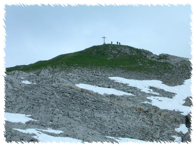
Eine kleine Alpstraße, später ein Pfad, führt euch in ca. 3
Stunden zum Hahnenköpfle (Bild rechts) (N 47°21.477 E 10°06.136,
2143m). Nimmt man den Sessellift, spart man eine Stunde. Vom
Hahnenköpfle aus hat man eine fantastische Aussicht über das
Gottesackerplateau, den Allgäuer Hauptkamm (Bild unten) und
manchmal sogar bis zum Bodensee. |
 Picture 1: Hahnenköpfle
 |
Das Gottesackerplateau ist eine Karstfläche, die sich auf ca. 25
km2 ausdehnt. Sie besteht aus Schrattenkalk
(Kalziumkarbonat CaCO3), der vor ca. 110 Millionen
Jahren im Meer der Kreidezeit abgelagert wurde. Wasser formte aus
dem löslichen Gestein im Laufe der Zeit eine typische
Karstlandschaft.
Lerne einige der typischen Karst-Formationen kennen, wie:
-
Karren (im Allgäu und in der Schweiz auch "Schratten"
genannt): Sie werden gebildet, wenn Wasser am Felsen entlang läuft
und dabei immer tiefere Rinnen bildet. Manchmal bleiben dann nur
noch sehr dünne Kalkwände bestehen.
-
Karstböden: Diese bilden sich entlang von Rillen im Kalk.
Das Wasser tritt in diese Rillen ein und weitet sie immer mehr. Oft
verlaufen die Rillen in zwei Richtungen, und zwar in 90°-Winkeln,
so dass der Boden einem riesigen Schachfeld gleicht. In den Spalten
finden oft seltene Pflanzen eine Nische zum Überleben.
-
Dolinen : Trichter oder senkrechte Öffnungen, die in den
ausgehöhlten Untergrund führen,oder flache Absenkungen größerer
Gebiete.
Der Cache besteht aus drei Aufgaben:
- Mache ein Foto mit deinem GPS und einem der
Schilder, die den Geologischen Rundweg um das
Gottesackerplateau markieren.
- Mache ein Foto von einer der oben genannten typischen
Karstformationen (mit dir) und deinem GPS. Nimm die Koordinaten
dieser Formation. Bestimme, um welche Art von Formation es sich
handelt.
- Logge deinen Fund mitsamt Fotos, den Koordinaten und der
Beschreibung von dem, was Du gefunden hast.
Hochgebirgscache, nur im Sommer und bei gutem Wetter zu
erreichen. Bitte geht nicht bei Nebel oder Regenwetter los!
You may park your car at N 47°20.577 E 10°08.320 (a small charge
has to be paid), but you can also go there by bus.
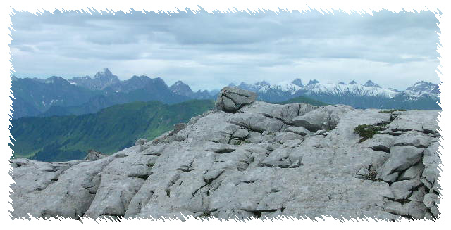 Picture 2: Allgäuer Hauptkamm
 |
A small mountain road, later a trail, leads within three hours
to the Hahnenköpfle (Picture 1) (N 47°21.477 E 10°06.136, 2143m).
Taking the chair-lift you may spare one hour. From the
"Hahnenköpfle" you have a fantastic view all over the
"Gottesackerplateau", the main Allgäu mountain ridge (Picture 2)
and sometimes even of the lake "Bodensee". |
The "Gottesackerplateau" is a karst-area of about 25
km2. It consists of limestone (calcium carbonate
CaCO3), deposited about 110 millions of years ago in the
sea during the chalk period. As time passed, water formed the
typical karst landscape as a result of subterranean erosion.
Learn more about typical karst formations like:
-
Karren (called "Schratten" in the Allgäu and in
Switzerland): They are formed when water runs down a slope
dissolving the rock, getting deeper and deeper. Sometimes only very
thin walls of limestone remain.
-
Limestone pavements : These are formed along cracks in the
limestone. The water enters the cracks and widens them as time goes
by. Often the cracks run into two directions within angles of 90°,
which then makes the limestone pavement look like a gigantic chess
board. Inside the cracks rare plants often find a niche to
survive.
-
Dolines: Sinkholes as vertical openings into caves or
shallow depressions of larger areas.
The cache consists of three tasks:
- Take a picture of one of the
signs indicating a geological walk around the
"Gottesackerplateau", along with your GPS.
- Take a picture of one of the typical karst formations described
above along with (yourself) and your GPS. Take the coords of this
formation and determine which kind of formation you have
found.
- Post the pictures, the coordinates and the description of what
you have found.
This is an alpine cache available only during summer and good
weather. Please don't go to the "Gottesackerplateau" during foggy
or rainy weather!