This is the seventh in a series of eight earthcaches being developed at major points of interest in Newberry National Volcanic Monument in cooperation with the staff of the Deschutes National Forest. The Lava Lands area is usually accessible by car from mid-May to mid-November. This earthcache is along The Trail of the Molten Land.
To log this cache post your favorite photo along the trail and e-mail me the answers to the following questions:
- Obtain coordinates for the trail name sign at the beginning of the Trail of the Molten Land.
- Given that the base of Lava Butte in the breach is at N 43° 54.910' W 121° 21.452' what is the distance and heading (from True North) across the flow to the base from the trail sign (above).
- According to a trail signs, how many square miles does the Lava Butte lava field cover? The answer to this is not the area of Newberry Volcano.
- According to a trail sign, explosive eruptions from Newberry reached as far as “_______” and “______”.
- According to a trail sign, how many places on the Deschutes River were blocked by the lava flow?
While doing this earthcache you may also be able to collect the necessary information to claim more than a dozen waymarks in the area.
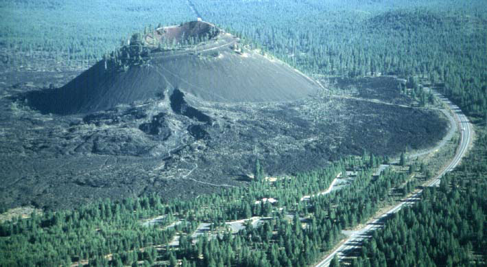 The Lava Butte area includes about a 1 mile segment of the NW Rift Zone of Newberry Volcano. About 7,000 years ago activity along the rift began with fire fountaining along the segment and small flows from the fountains. After a few days activity localized at the location of Lava Butte and a cinder cone began to form. As degassed magma rose in the cone it broke through the thin south side of the cone and fed a series of lava flows that spread to the west and north blocking the Deschutes River.
The Trail of the Molten Land takes you out across the flows to their source on the south flank of Lava Butte. Along the trail there are a series of interpretive signs about some of the many features. At the upper end of the trail is the Phil Brogan Viewpoint with a view across the lava flow to the Cascades.
View from Phil Brogan View Point
| EAST |
|
|
|
|
| |
S 35 E
|
-
|
6 mi
|
-
|
Mokst Butte -- 7,000 year old cinder cone along NW Rift Zone of Newberry Volcano |
| |
S 27 E
|
-
|
13 mil
|
-
|
North Paulina Peak -- Cinder cone on north rim of Newberry Caldera |
| |
S 3 E
|
-
|
6 mi
|
-
|
Sugar Pine Butte -- Cinder cone with microwave tower |
| SOUTH |
|
|
|
|
| |
S 22 W
|
-
|
4 mi
|
-
|
Abbot Cinder Pit |
| |
S 34 W
|
-
|
64 mi
|
-
|
Mt. Thielsen -- Deeply glaciated composite volcano |
| |
S 46 W
|
-
|
28 mi
|
-
|
Davis Mountain -- Shield volcano |
| |
S 56 W
|
-
|
48 mi
|
-
|
Diamond Peak -- Deeply glaciated composite volcano. |
| |
S 57 W
|
-
|
36 mi
|
-
|
Maiden Peak -- Glaciated composite volcano with plug. |
| |
S 58 W
|
-
|
21 mi
|
-
|
Round Mountain -- Cinder cone |
| |
S 65 W
|
-
|
19 mi
|
-
|
Lookout Mountain -- Shield volcano |
| |
S 87 W
|
-
|
17 mi
|
-
|
Sheridan Mountain -- Cinder cone capped shield volcano |
| WEST |
|
|
|
|
| |
N 81 W
|
-
|
16 mi
|
-
|
Kwolh Butte -- Cinder cone on south flank of Mt. Bachelor |
| |
N 75 W
|
-
|
17 mi
|
-
|
Mt. Bachelor -- Summit cone on shield volcano |
| |
N 71 to 57 W
|
-
|
4 mi |
-
|
Benham Buttes -- 1,800,000 year old domes. The 7000 year old Lava Butte flow abuts the east end of the domes and dammed the Deschutes River resulting in a lake. When the lake overflowed and drained, Benham Falls was created. |
| |
N 66 W
|
-
|
15 mi
|
-
|
Tumalo Mountain -- Small cinder cone capped shield volcano |
| |
N 57 W
|
-
|
24 mi
|
-
|
South Sister -- Composite volcano |
| |
N 56 W
|
-
|
21 mi
|
-
|
Broken Top -- Deeply glaciated composite volcano |
| |
N 53 W
|
-
|
27 mi
|
-
|
Middle Sister -- Glaciated composite volcano |
| |
N 50 W
|
-
|
27 mi
|
-
|
North Sister -- Glaciated shield volcano |
| |
N 49 W
|
-
|
4 mi
|
-
|
Ryan Meadow -- Meadow formed as result of drainage changes caused by the 7000 year old Lava Butte flow |
| |
N 35 W
|
-
|
16 mi
|
-
|
Triangle Hill -- Cinder cone |
| |
N 33 W
|
-
|
6 mi
|
- |
Red Hill Cinder Pit |
| |
N 32 W
|
-
|
46 mi
|
-
|
Three Fingered Jack -- Glaciated shield volcano |
| |
N 23 W
|
-
|
57 mi
|
-
|
Mt. Jefferson -- Glaciated composite volcano |
| |
N 21 W
|
-
|
1 mi
|
-
|
Green Mountain -- Faulted cinder cone capped shield volcano |
| NORTH |
|
|
|
|