This is the sixth in a series of eight earthcaches being developed at major points of interest in Newberry National Volcanic Monument in cooperation with the staff of the Deschutes National Forest. The Benham Falls area is generally accessible by car from early-May to mid-November.
To log this cache post your favorite photo along the trail and e-mail me the answers to the following questions:
- Title of interpretive sign at N 43° 55.954 W 121° 25.006
- Proceed to point #3, along the way at the footbridge, given that each plank on the footbridge is 1 foot wide, (a) how long is the bridge and (b) how wide is the river channel.
- Name on sign at N 43° 56.359 W 121° 24.784
While doing this earthcache you may also be able to collect the necessary information to claim more than a dozen waymarks in the area.

 Across the river from the parking lot are Benham Buttes, a group of 1,800,000 year old rhyodacite domes. As Newberry Volcano has grown over the last half million years it has gradually been displacing the Deschutes River westward. Over the last 100,000 years, two eruptions have shaped the Benham Falls area. Prior to 74,000 years ago, the Deschutes River was located somewhere to the east between Benham Buttes and Green Mountain (north of Lava Butte). About 74,000 years ago an eruption on the northwest flank of Newberry produce a large tube-fed basalt flow that moved north and west. Much of the flow pasted through Lava River Cave and another branch went north to underlie Bend and extend almost to Redmond. This large flow destroyed the previous river channel and over time a new channel was established along the western edge of the flow against the edge of Benham Buttes. Over the next 70,000 years the river cut a new channel along the margin of the flow.
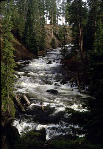
Prior to the eruption of Lava Butte, the Deschutes River occupied a canyon (80 to 100 feet deep) from Bend to a point several miles upstream from Benham Falls. The eruption occurred 7000 years ago and again blocked the Deschutes River. The flow filled the deep canyon of the Deschutes from the Benham Falls area to Dillon Falls area with more than 100 feet of lava and formed a dam resulting in a lake which extended up river beyond the Sunriver area. As the lake rose, the lowest point was a low saddle on Benham Buttes. As the lake overflowed it cut the channel that is now Benham Falls.
When you stand on the bridge on the trail to Benham Falls, the rim rock you see to the south is the rim of the old river canyon.
Map showing change in river's course following Lava Butte eruption.
For more details on the geology check here.
In addition to the geology of the area, there is an interpretive trail dealing with the history and ecology of the area.