This is the fourth in a series of eight Earthcaches being developed at major points of interest in Newberry National Volcanic Monument in cooperation with the staff of the Deschutes National Forest. This EarthCache is located along two trails which begin from the parking lot.
To claim this Earthcache you need to post a photo(s) of your favorite view(s) and email me the answers to the following questions:
- What is written near N 43° 42.728’ W 121° 16.958’?
- Using your GPS what is the distance and heading (from True North) from the upper viewpoint to the viewpoint across the creek (N 43° 42.761’ W 121° 16.984’). This will give you the width of the canyon.
- Using your GPS what is the distance and heading (from True North) from the lower viewpoint to the viewpoint across the creek (N 43° 42.761’ W 121° 16.984’).
While doing this earthcache you may also be able to collect the necessary information to claim several waymarks in the area.
If you would like to visit the viewpoint on the other side of the creek, park at the Paulina Lake Day Use site. Walk to the lake’s outlet, cross Paulina Creek at the dam/road, and take the Peter Skene Ogden Trail west for about a third of a mile.
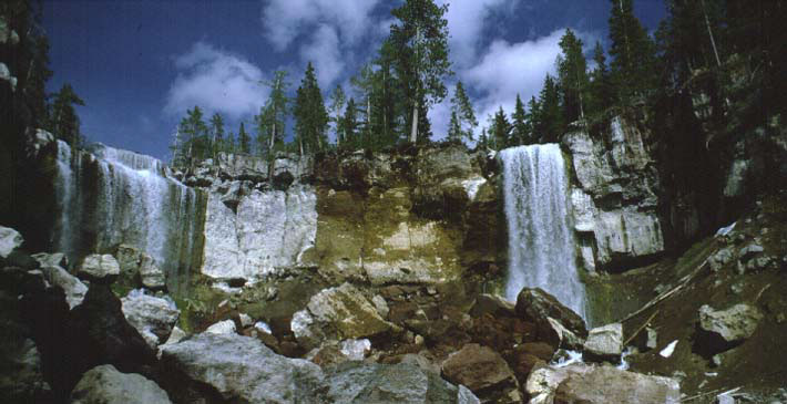 Paulina Creek drains Paulina Lake, less than half a mile to the east. Paulina Creek Falls is a double falls that drops about 60 feet onto the jumble of rocks below. The rocks that form the cliffs of the falls are agglutinated andesitic pyroclastic deposits formed of many thin to thick units during the caldera forming eruption about 75,000 years ago. Below the cliffs are poorly sorted and bedded ash, lapilli, and blocks. The contact between the lower and upper unit is gradational and most likely represents a change in eruption style from relatively cold material to hot material that welded together.
The jumble of rocks at the base of the falls is the result of the falls slowly eroding their way upstream. Near the end of May 1983 a large section of the cliff between the falls fell to the base of the falls due to erosion of the weaker deposits at the base of the cliff and freeze-thaw action behind the cliff face.
As you walk out to the upper viewpoint notice how much wider the canyon is downstream from the trail than it is at the viewpoint. The narrower canyon at the viewpoint is the result of a large flood sometime between 5000 and 2000 years ago. Before the flood there was plenty of time for freeze thaw action to attack the canyon walls and widen them as the falls moved slowly upstream. At the time of the flood the volume of flow was 220 to 550 times more than the current average stream flow rate (18 cubic feet per second). Studies of flood deposits and erosional features along Paulina Creek indicate that the estimated flow rate was in the range of 4,000 to 10,000 cubic feet per second. This large flood rapidly (a day or two) cut a narrow channel upstream a couple hundred feet. The most likely cause for the flood was the collapse of a small 5 to 8 foot high waterfall at the lake's outlet suddenly lowering the lake that amount. Image what will happen when Paulina Creek Falls reaches the lake at some time in the future.