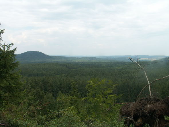
10 km SZ od Horsovskeho Tyna nachazi se, cituji: "granitoidni teleso...ukazka klasicke ringove intruze, jednoznacne nejlepsi jakou v Ceske republice mame, nemajici konkurenci v cele stredni Evrope." Z hlediska normalniho cloveka je to ovsem zhruba 11 kopcu rozhozenych ve velmi puvabne skupine temer dokonale kruznice o prumeru asi 5-7 km s dvema kopci centralnimi, takze dokonale pripominajici byvaly obrovsky krater. Cele je to porostle prevazne borovym lesem.
Zhruba jeste pred 15 lety se na hrebeni vyskytovala mista nabizejici uchvatny pohled na celou skupinu najednou. Nyni jsou ovsem asi uz vsechny vyhlidky znacne omezeny vegetaci. Pokud by nekdo jeste nasel misto poskytujici generalni pohled, dekuji predem za souradnice.
Kdo rad pocita, se uz urcite divi nazvu Sedmihori. Je to mozna proto, ze z venku je videt vzdy maximalne 7 kopcu (jako druzice v GPS), nebo ze se v uzsim smyslu bere v uvahu jen nejvyraznejsi jihozapadni segment. A na jeho nejzapadnejsim vrcholu zvanem Vidicky vrch je ve vysce 589 m n.m. ukryta tato cache.
"The granitoid body .... the illustration of the classical ring intrusion , the best we can see in the Czech Republic, with no competitor in the whole Central Europe" is located 10 km south-west from Horšovský Týn. From the point of view of the common person it is about 11 hills which are situated in a very nice-looking group forming almost the circle with the average 5-7 km and two central hills, reminding former gigantic crater. Everything is covered mainly by the pine-trees forest.
Fifteen years ago one could have general view on the whole group from the edge, but nowadays, because of the vegetation, the view is strongly limited. If anyone finds the possibility for such a view I will be very grateful to get the position datas.
Those, who like to count can be surprised by the name Sedmihorí (Seven mountains). Maybe it is before that from outside one can see 7 hills in maximimum (as the satellites in GPS), or because only the most impressive southwestern segment is counted. This cache is hidden here, on its most western hill called Vidicky vrch, in the altitude 589 km above the sea.
Sedmihori je vyhlaseno prirodnim parkem, takze se do blizkosti ukrytu na ctyrech ani dvou tlustych kolech nedostanete. Svuj samohyb muzete zanechat treba na N49 36.023 E012 53.203 u Mirkovske hajovny, kde zacina i pomerne vycerpavajici (informacne) naucna stezka. Oproti tomu se pro cyklistu Sedmihori zda idealnim terenem. O samotnem okoli cache popr. celem JZ hrebeni si ovsem ani to netroufam tvrdit. Pokud napadne pul metru ci vice snehu, tak cache asi nenajdete.
Sedmihorí is declared as a national park so you cannot use your car or motorcycle. Your vehicle can be left on N49°36.023 EO12°53.203 near gamekeeper´s house in Mirkov, where also the very informative nature trail starts. On the other hand this is a perfect terrain for biking. Unfortunately this is not possible to be said about the very surroundings of the place where cache is hidden. In the case of half metre of snow you won´t be probably able to find it.