This track brings you
to an island beach in a Kitsap County Park.Frozen water
formed King County in much the same way that a construction
crew builds a house. The crew brings in materials, adding
some here, taking away some there, and then, when the job is
finished, leaves.
So too with the frozen water that
made up Ice Age Glaciers. The shape of the land and lakes, the
makeup of the earth’s surface, the way the water flows beneath the
ground, all were determined by the powerful forces of
glaciers.
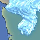

Imagine Puget Sound under a mile of ice. 20,000 years ago,
glaciers covered everything in between the Olympics and the Cascade
mountains and spread as far south as Olympia. The ice over Seattle
was higher than five Space Needles (3,412 feet.) This huge glacier
was called the Puget Lobe of the Cordilleran Ice Sheet.
Glacial ’erratics’ were also carried down; they are large
boulders often seen along beaches or in open fields. Most were
eroded from mountains in British Columbia, and fell on top of a
glacier, whence they ‘hitchhiked’ down to the US as the glacier
advanced. When the glacier melted, these boulders were left behind,
a stone unlike any surrounding it now.
Glaciers containing up to 2,383 cubic miles of ice pushed over
the Puget lowland. In some places, the heavy pressure of the ice
sunk the earth's crust. When the ice finally retreated to the
north, it left behind deeply gouged channels, north-and-south
oriented passages and bays, creating ‘roller-coaster ‘ roads, up,
down, up and down. As the glaciers moved north and south, they
scooped out the land like a bulldozer, pushing it into ridges as
they went. These, called Drumlins, occur all over Kitsap County,
but the best ones here are in South Kitsap, and along Sedgewick
Road.
Weather, waves, and gravity reworked the glacial sediment,
molding landforms and shorelines like frosting on a cake. The
results are the beaches and bluffs that now edge the Sound. Many
shoreline bluffs reveal layers of glacial activity in soils and
rocks. These layers can slide when saturated. The geology of Puget
Sound bluffs varies from one location to the next. Although the
generalized geologic conditions described here occur broadly and
demonstrate common landslide-prone features, they do not apply to
all shorelines and landslides are certainly not limited to these
circumstances.
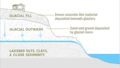
Please, in order to claim this virtual cache, email me with
two answers: one- is this area made up of glacial till, outwash or
silts and clays, and two- how many eyes on the track.
Congratulations to the Seabeck Tribe on FTF, in the
rain!