Die Koordinaten sind nicht die des Caches !!
The coordinates shown above are not the cache location !!
 Deutsche Beschreibung
Hallo Cacher,
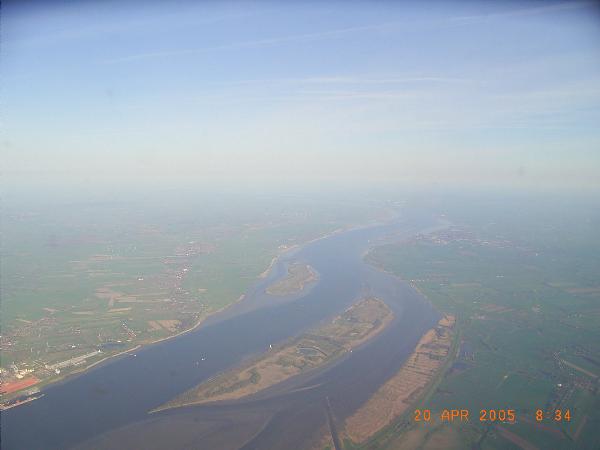
das Luftbild oben habe ich am 20.04.2005 um 08:34 kurz nach dem Start von Hamburg-Fuhlsbüttel gemacht. Um den Final zu finden, musst Du herausfinden welche Inseln man dort unten sehen kann. Ermittele die Koordinaten der unteren langen Spitze der unteren Insel. Verwirf sämtliche Nachkommastellen, dann hast Du den Ausgangspunkt N 53° ??.000 / E 9° ??.000 für die Peilung zum Final.
Nun fehlen nur noch Entfernung und Richtung. Wie weit ist es von der unteren Spitze der oberen Insel, bis zur unteren Spitze der unteren Insel ? Runde auf oder ab, um auf ganze Kilometer zu kommen. Diese Zahl sei X.
Der Final liegt dann von N 53° ??.000 / E 9° ??.000 gepeilt (wahre Nordreferenz) bei:
(24*X + 4)° / (6*X - 1,25)km, korrigiere Nord +00 00.117 / Ost +00 00.212
Peilungsergebnisse können je nach verwendeter Methode zum Teil recht stark abweichen. Ihr könnt Euch Euer Ergebnis daher gerne von mir per Mail bestätigen lassen.
Bitte beachtet unbedingt den neuen Schwierigkeitsgrad fürs Gelände ! Alles was Ihr tut um an den Cache zu kommen ist Euer eigenes Risiko ! Der Cache ist eine schöne stabile Doppel-Box von ca. 2,5 Litern. Bitte lasst Logbuch, Stift und Geocache-Hinweis im Cache !
Viel Spaß !
 English description
Hi there Cacher,
the aerial picture was taken on April 20th 2005 at 8:34 pm, a few minutes after take off from Hamburg-Fuhlbüttel airport. For the final, you need to find out which islands we can see down there. Find the coordinates of the lower edge of the island that can be seen at the bottom of the picture. Strip off all decimals from the minutes of the result, and you've got the starting point N 53° ??.000 / E 9° ??.000 for the waypoint projection to the final.
Now we need distance and direction. Find the distance between the lower edge of the island higher up in the picture and the lower edge of the island at the bottom. Round up or off to get a number of full kilometers. Let this number be X.
Find the final with a waypoint projection (true north) from N 53° ??.000 / E 9° ??.000 at:
(24*X + 4)° / (6*X - 1,25)km, adjust north +00 00.117 / east +00 00.212
The results of the waypoint projection may greatly vary depending on the method that is chosen. You are therefore welcome to have your result confirmed by mail.
Please note the new terrain difficulty rating ! Everything you do to get to the cache is at your own risk ! The cache is a nice robust box of approx. 2.5 liters. Please leave stash note, logbook + pen in the cache !
Have Fun !