Höhendifferenz: 450 Hm
Dauer: ca. 3 h
Parkplätze:
P1 (kostenpflichtig): N 48° 44.951, E 13° 49.926
P2 (kostenlos): N 48° 44.702, E 13° 50.055
ideal anschließbar wäre die Wanderung zu AL044 - AS (+4 h / +450 Höhenmeter)
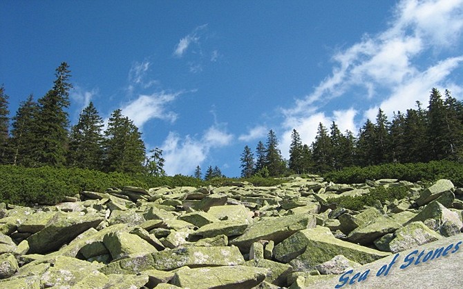
Der Cache führt dich den Südhang des Böhmerwaldes hinauf zur Felsblockhalde "Steinernes Meer" mit wunderschönem Ausblick - die Alpengipfel scheinen zum Greifen nahe. Er liegt in der Nähe des Dreiländerecks Österreich-Deutschland-Tschechien. Wanderer können sich völlig frei über die Grenzen bewegen, es gibt keine Zäune oder Zöllner. Eine tolle Sache, wenn man sich noch an die Zeit des eisernen Vorhangs erinnert. Wie immer im Ausland, muß man aber dennoch einen Reisepaß oder Personalausweis mitnehmen.
Die Wanderung ist nicht allzu anstrengend und du kannst anschließend entlang des Kamms noch z.B. zum Gasthaus auf der bayerischen Seite, zum Dreiländereck und zum Plöckenstein weiter wandern.
Folge immer den blau-weißen Markierungen!
Station 1: Spurensuche
48° 45.424
13° 49.665
Wann wurde der Mann mit der lustigen Barttracht geboren? Bilde die Quersumme dieser Zahl! (= A)
Station 2: Glaub' nicht an Radfahrer
48° 45. (A*3 + 4) *10 + 9
13° 49. (A*5 + 1) *10 + 5
Halte Ausschau nach einem Radfahrer, aber folge nicht seinem Weg. Nimm die linke Ziffer seiner zugehörigen Zahl! (= B)
Station 3: Sesselsuche
48° 45. B*100 + 7*A - 3
13° 50. B*40 - A - 4
Der blecherne Schildbürger zeigt dir den Weg zu einem Berg, an dem mehr als zwei Leute eine Sitzung abhalten können (Trialog). Welche Zeit dorthin benötigt der durchschnittliche Wanderer, der vorher noch übers Steinerne Meer surfen möchte? Bilde die Ziffernsumme! (= C)
Station 4: Meeresbrise
48° 46. 20*C + B
13° 50. (B + C + 1) *10 + 6
Folge weiter den blau-weißen Zeichen. Bald schon siehst Du auf das Meer. Halte kurz inne und gehe dann zur Station. Hier haben mir die Ranger im Laufe der Zeit immer mehr Schilder montiert, tststs! Nimm die höchste weiße Ziffer auf rotem Untergrund! (= D) (solange gültig bis halt irgendein Lustiger wieder grüne Schilder anschraubt 
DER CACHE:
48° 46. (B + C + D) *10 - 25
13° 49. (A + B + C + D + 15) * (B + D) - 9
Folge dem steinigen Weg so lange Du kannst und genieße die Aussicht. Der Cache befindet sich in einem transparenten Plastikbehälter (22 x 14 x 7 cm) mit blauem Deckel.
Happy Hunting wünschen euch
slackliner & PPete!!
Der Cache wurde von slackliner gelegt und im August 2009 von PPete adoptiert sowie an die aktuelle Situation an den Stationen angepasst.

ENGLISH:
Altitude difference: 450 m
Hike time: ca. 3 h
Parking lots:
P1 (with fees): N 48° 44.951, E 13° 49.926
P2 (without fees): N 48° 44.702, E 13° 50.055
you could proceed your hike to AL044 - AS (+4 h / +450 altitude meters)
The Cache guides you up through the southern slope of the Bohemian Forest to a rock block dump "Steinernes Meer" (engl: Sea of Stones). There you will enjoy a beautiful, scenic view - the alpine summits seem very close. It is close to the border triangle of Austria-Germany-Czechia. Hikers can freely pass the borders, there are no fences or customs officers. That's great, just remember the era of the iron curtain here. Of course you have to take your passport or personal ID-card with you.
The hike isn't very exhausting and you can continue your hike to the bavarian inn, to the border triangle and to Plöckenstein.
Always follow the blue-white trail marks!
Stage 1: Searching for clues
48° 45.424
13° 49.665
When was the man with the strange beard born? Calculate the sum of digits! (= A)
Stage 2: Don't believe in bikers
48° 45. (A*3 + 4) *10 + 9
13° 49. (A*5 + 1) *10 + 5
Look out for a man sitting on his bike, but do not follow his way. Take the left digit of his number! (= B)
Stage 3: Searching for armchairs ("Sessel")
48° 45. B*100 + 7*A - 3
13° 50. B*40 - A - 4
The yellow metal friend shows you the way to a mountain ("berg") where more than two people can hold a sit-in (trialog, tri=three="drei"). What time takes it to get there, if a hiker wants to go via ("über") Steinernes Meer (=Sea of Stones)? Calculate the sum of digits! (= C)
Stage 4: Breeze from the Sea
48° 46. 20*C + B
13° 50. (B + C + 1) *10 + 6
Still follow the blue-white trail marks. Soon you'll see the Sea. Have a short rest and then walk to the Station. Look for white digits on red background. Take the highest of these digits! (= D)
THE CACHE:
48° 46. (B + C + D) *10 - 25
13° 49. (A + B + C + D + 15) * (B + D) - 9
Stay on the stony way as long as you can and enjoy the beautiful view. The cache is in a transparent plastic container (22 x 14 x 7 cm) with blue cover.
Have Fun,
slackliner & PPete!!
The Cache was hidden by slackliner , adopted and changed by PPete in August 2009 to match the current situation at the stages.