The São Domingos Mine is located approximately 17 km NE of Mértola, in the heart of the Iberian Pyrite Belt. It takes its name from the village of the same name where the mine is located. Geologically the Mine area consists of the outcropping volcanic and sedimentary rocks that vary in age from 542 to 251 million years.
Mining in the São Domingos area is known to have started before the Roman colonisation of the Iberian Peninsula that took place in approximately 218 BC and the mining history of São Domingos can be divided into three distinct mining periods.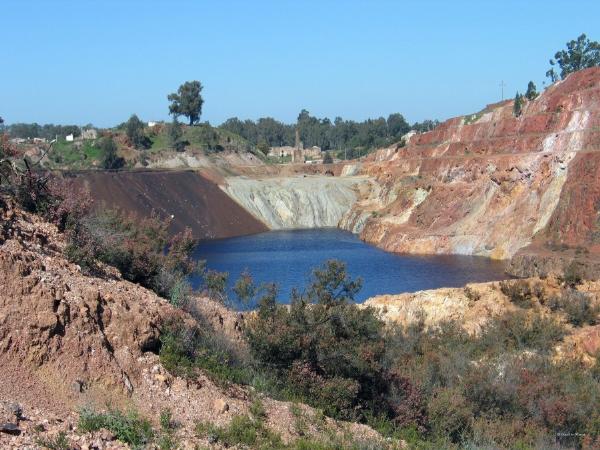 The first, attributed to the Phoenicians and Carthaginians in the Calcolithic (copper age) period, which began 4300 ago, is perhaps the least known. Archaeological finds of three polished stone axes, similar to ones found in Rio Tinto (Spain), indicate the presence of pre-Roman mining activities at São Domingos.The second mining period is clearly attributed to the Romans who intensified the production of copper on a large scale. Thirty-nine Roman coins depicting emperors from Augustus (27 BC to 14 AD) to Theodosius (379-395 AD) were found on site attesting to the Roman presence. Mining activities are deemed to have lasted 385 years, from 12 to 397 AD. The main reason that the Romans established themselves in a so desert-like region that offered few possibilities of arable and livestock farming, was not for the extraction of copper, already intensely explored in other zones of the Empire, since the Roman economy did not have large requirements for copper but rather for gold and silver. It is calculated that the Romans processed some 3 Mt of ore based on the amount of dump material available on site and based on the amount of slags found, it is estimated that some 750 000 tons of pyrite and copper ore were removed from São Domingos in this period. Mining took place to a depth of 40 m and the average concentration of the copper and sulphur ores was 2.75% and 46%, respectively.
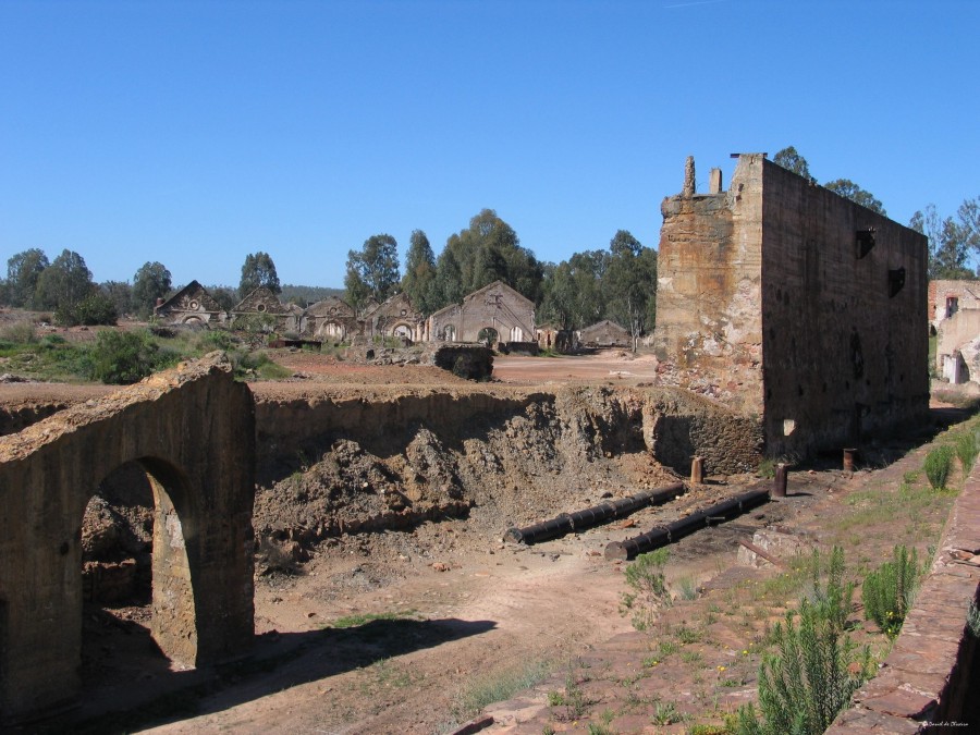 In the 1850’s, Victor Ernest Deligny, then technical manager of the Tharsis and Calañas Mines, amongst others, ordered that Nicolas Biava carry out exploration in the “Santo Domingos area”. In 16 June 1854, the Municipality of Mértola received a concession request by Biava for the São Domingos area that was subsequently granted. He later transferred his concession to Deligny, who in 1855, created La Sabina Mining Company with Spanish and French capital with a concession area of 798 km2. Later, in January 1959, Mason & Barry, with their headquarters in London, lease the concession from La Sabina following economic interests favourable to both parties and a process of industrialised mining at São Domingos takes off on its third and final period.Between 1859 and 1867 mining operations consisted of underground operations by prolonging the existing shafts, haulages, drives and stopes using the relic infrastructures found on site. Average grades of 3% Cu and 50% S were mined in this period and the pyrite was shipped to England, via the Pomarão Harbour where, through ustulation (a process that causes the loss of volatile components) for the manufacture of sulphuric acid, the copper was extracted. Heavy maritime traffic at the Pomarão Harbour, 18 km south of the mine, and lower metal prices, prompted (James) Mason to build a treatment plant to process poorer ore at Achada do Gamo. From 1868 till its closure in 1966, due to exhaustion of the ore, São Domingos continued as an open cast exploration.
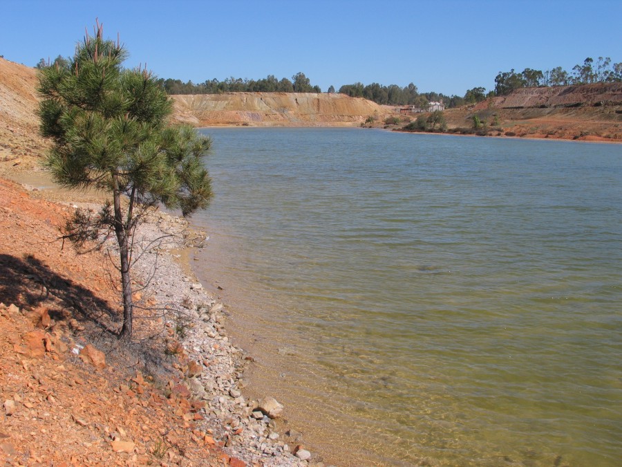
It is calculated that all the periods of mining resulted in the production of 25 Mt, and mine waste material in the area is estimated at several hundred thousand tons. In this context, important environmental problems are associated, which are visible within an area around 50 km2.
Achada do Gamo
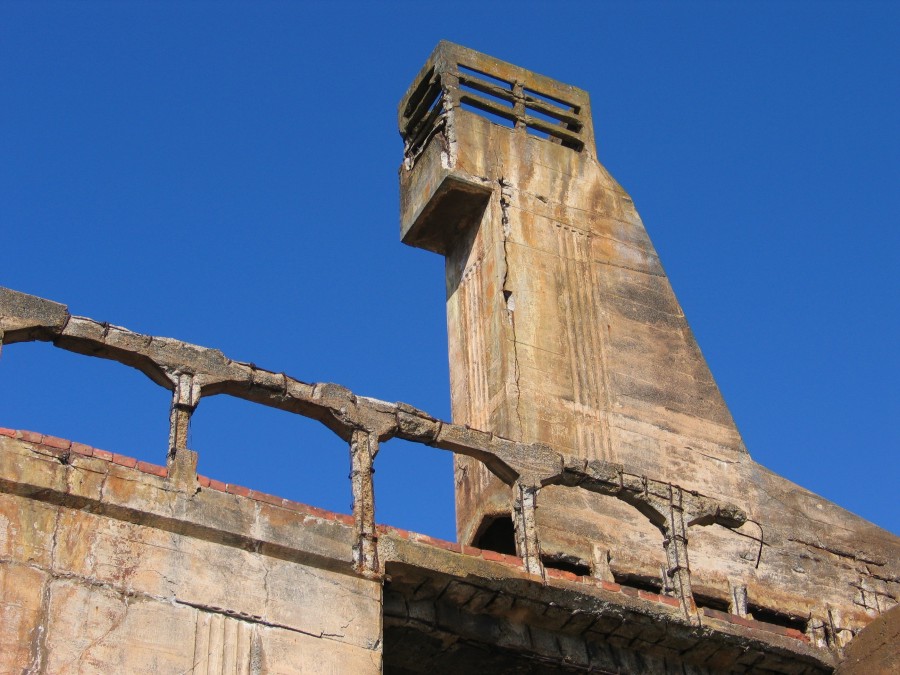
The Achada do Gamo site is characterised by having a myriad of old mining infrastructures that are surrounded by several dumps, some containing milled ore, building debris, bedrock and closer to the dam, sediments derived from the run-off of these materials.
Due to the extremely high concentrates of S-bearing minerals as well as sulphate salts, it is common to find carapaces made up of native sulphur crystals and neo-formed sulphates (melanterite, jarosite) at the edges of the various dams in the region. The sulphates are mostly visible in summer as they dissolve when it rains.
The cache
To log this cache you must:
1- Tell me what is the colour of the existing mine dumps that are immediately north of the information panels near coordinates N37º 40.127; W7º 29.585.
2- Get hold of some of this material, feel it between your fingers and tell me if it is fine-grained or coarse-grained.
3- Examine the dump material closely and tell me what other colours of material is seen. You should be able to identify at least another three (3) colours.
4- To validate your log and to make sure that you have at least read a little bit about the geology at the São Domingos Mine, have your picture taken at the information panels - you can chose to appear in the picture or take a picture of a piece of paper with your nick with the panels as the background. This picture must ten be attached to the log. Mandatory task after 31/10/2019.
You should also consider starting your exploration of S. Domingos near the cache coordinates and work your way south towards the Achada do Gamo sulphur factory (N37º 38.953; W7º 30.655) and then on to Telheiro (N37º 37.981; W7º 31.030), site of some old mine offices. Note on your left, just before the bridge, the stripped valley sides, where the mine used to dump acid waters to evaporate some of it before dumping them in the streams. Please note as well that on the edges of the mine lakes and margins of streams, grow erica andevalensis, which are able to withstand extreme levels of sulphur toxicity.You should then retrace your steps back to Moreanes and follow the tarred road to the Pomarão harbour (N37º 33.382; W7º 31.469), 18 km south of S. Domingos, where the ore was shipped to England and where you can enjoy some beautiful views of the Chança and Guadiana rivers.
Please note:
Please be careful where you step and where you drive. This side of the mine is the site of several inclined shafts (now sealed) that the less weary traveller may fall into. Another point to take into consideration is the fact that waters in the various lagoons and lakes is derived from acid mine drainage. Hence, they have extremely low pH’s (often < 2) that are harmful to both man and beast. Some of these are being fenced off to prevent accidents but you are free to wander amongst the ruins and get the feel for some industrial archaeology remains.

A Mina de São Domingos situa-se no Baixo Alentejo, na margem esquerda do Guadiana, a 17 km da Vila de Mértola e encontra-se inactiva desde 1966. Os terrenos da região são quase todos de xisto, o clima é quente e seco, nos meses de Verão as temperaturas máximas ultrapassam regularmente os 30 - 35º Celsius.A Mina de São Domingos integra-se na Faixa Piritosa Ibérica que constitui uma das mais importantes Províncias Metalogénicas de sulfuretos maciços polimetálicos à escala mundial. Outrora o minério (pirite) era extraído 24 horas por dia, inicialmente transportado do interior das minas para a superfície por burros, mais tarde por vagonetas; algum minério era exportado para Inglaterra e outro, transformado para construção de máquinas em oficinas anexos às próprias minas, era também exportado para Inglaterra. A mina, que empregou milhares de trabalhadores, foi considerada uma das maiores fontes do equilibro económico para o concelho. Sobre a Mina de São Domingos, podemos concluir que entre os anos de 1855 e 1966, foram retirados à serra de S. Domingos cerca de 25 milhões de toneladas de minério.O primeiro registo oficial é do ano de 1858 e refere a extracção de 236 toneladas de pirite sulfurosa. Em 1862, apenas quatro anos depois, são exportadas para Inglaterra quase 120.000 toneladas de pirite, metade do consumo daquele país. O ano de 1912 regista a cifra mais alta de minério exportado ao longo de toda a história da Mina de S. Domingos: 432.350 toneladas de pirite. No ano de 1965, o último ano de extracção no interior do labirinto subterrâneo, apenas foram extraídas 66.823 toneladas. Dois tipos de extracção marcaram a exploração na Mina de S. Domingos: subterrânea e a céu aberto. A primeira levou à criação de um intrincado sistema de galerias, organizadas por pisos separados entre si cerca de trinta metros, até à profundidade de 405 metros, a partir do piso 120. A exploração mineira a céu aberto, realizada no local onde hoje está a "corta", iniciou-se em 1867 e terminou em torno da década de oitenta do século XIX, com a remoção de mais três milhões de metros cúbicos de terras, numa área de cerca 42.000 m2 e atingindo uma profundidade de cerca 100 metros. 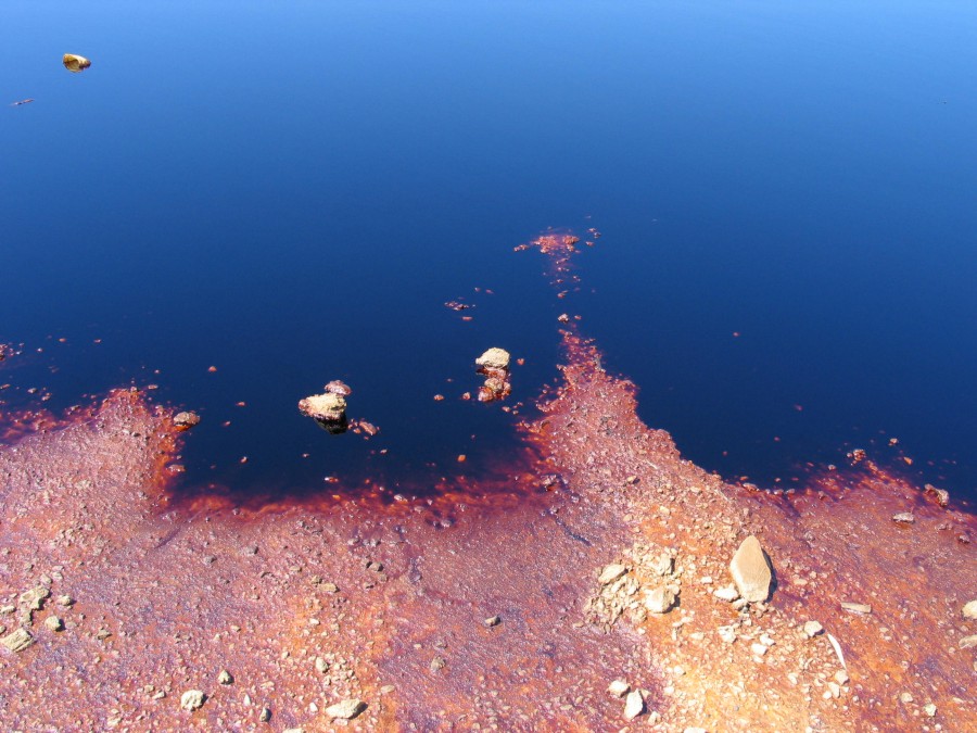 Actualmente a paisagem que se observa da mina não é, sem duvida alguma, a de outrora. A mina encontra-se abandonada (apresentando apenas as ruínas) e em redor destas encontram-se lagoas ácidas (pH aproximadamente de 2,4) que foram criadas há mais de uma dezena de anos para fazer decantação das escorrências da antiga mina. Esta situação de abandono da mina é preocupante, uma vez que coloca sérios problemas ambientais, não só a nível dos impactos paisagísticos, mas também dos ecossistemas afectados. Estas ditas águas ácidas são, não só prejudiciais para os solos (que ficam assim contaminados), nem para os ecossistemas que se encontram junto das minas, mas também para linhas de água (algumas para consumo de populações). A linha de água que desagua na albufeira da barragem construída pelos espanhóis no rio Chança atravessa as escombreiras dos rejeitados, libertados pelos fornos das antigas minas. Ao longo do percurso desta linha de água, esta recebe o líquido lixiviado com enorme percentagem de óxidos. Esta água é para o fim de consumo humano ou para regas!! Contudo, apesar de todos os malefícios que o abandono da mina e que as águas ácidas podem trazer para o meio ambiente e até para o próprio Homem, temos de ver também a parte, não positiva, mas não tão negativa assim. É muita a gente que utiliza a água das lagoas ácidas para curar ferimentos. Dizem os mais velhos que esta água cura os males. (Adaptado de Cruz, A., Sousa, A. and Pereira, R., 2004. Mina de S. Domingos - uma intervenção urgente! School report, Escola EB 2,3 /S S. Sebastião).
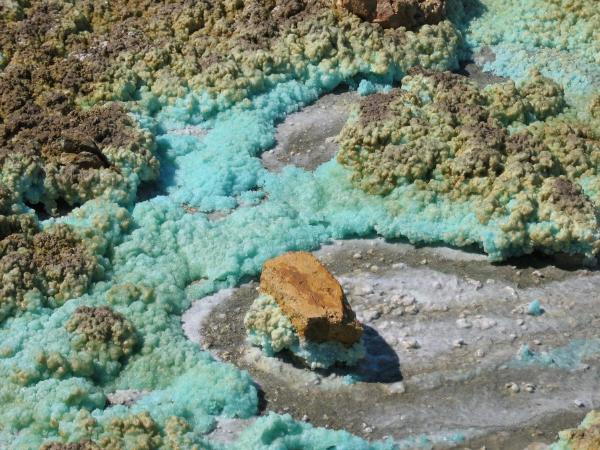 A cache
Para fazer o log desta cache é necessário que me digam qual a cor das escombreiras masi claras imediatamente a norte dos paineis informativos perto das coordenadas N37º 40.127, W7º 29.585.
Deve começar a sua visita à mina de S. Domingos na zona das coordenadas da cache, dirigindo-se depois para Sul até à antiga fábrica de enxofre, na Achada do Gamo (N37º 38.953, W7º 30.655). Daqui deverá seguir até ao Telheiro (N37º 37.981; W7º 31.030), local de antigas infraestruturas da mina. Antes de atravessar a ponte, repare à sua esquerda (lado Este), nas encostas completamente despidas de vegetação, devido ao vazamento de  águas ácidas, resultantes do processamento de minério. Assim, através da sua evaporação, evitava-se que fossem despejadas nas ribeiras maiores volumes destas águas contaminadas. Repare também que, na orla das lagoas e nas margens das ribeiras, se encontram pequenos arbustos de erica andevalensis, planta altamente resistente a níveis tóxicos de enxofre. A seguir deve voltar à povoação de S. Domingos, seguir para Moreanes e rumar ao Pomarão (18 km a sul da mina de S. Domingos, N37º 33.382; W7º 31.469), local da embarcação do minério para Inglaterra, onde poderá desfrutar de uma bela vista sobre os rios Guadiana e Chança, junto ao antigo cais de embarque do minério. Atenção: Cuidado onde mete os pés e por onde conduz. O lado Oeste da corta é o local onde os acessos subterrâneos para a mina eram feitos, existindo ainda alguns poços e rampas (agora selados) onde o visitante mais distraído pode cair. Outro ponto a ter cuidado é o referente às águas das várias lagoas. A sua origem deve-se a drenagem ácida, pelo que tem pH’s muito baixos (< 2) e portanto são altamente corrosivas. Algumas destas lagoas estão actualmente a ser vedadas para maior segurança mas, no entanto, pode-se e deve-se passear entre as ruínas do antigo espólio da mina.


 The most exciting way to learn about the Earth and its processes is to get into the outdoors and experience it first-hand. Visiting an Earthcache is a great outdoor activity the whole family can enjoy. An Earthcache is a special place that people can visit to learn about a unique geoscience feature or aspect of our Earth. Earthcaches include a set of educational notes and the details about where to find the location (latitude and longitude). Visitors to Earthcaches can see how our planet has been shaped by geological processes, how we manage the resources and how scientists gather evidence to learn about the Earth. To find out more click HERE.