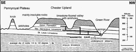
350 million years ago a shallow sea covered most of the southeastern United States. About 280 million years ago, the sea level started to drop and the continent began to rise, exposing layers of limestone and sandstone. Forces at work beneath the earth's crust caused it to slowly rise, buckle and twist, causing tiny cracks between and across layers of limestone and sandstone. At the same time river systems as we know them today slowly developed. By about three million years ago a sandstone-capped plateau stood above the Green River, and a low, almost flat limestone plain extended southeast of what is now Interstate 65. Rain water, acidified by carbon dioxide in the soil, seeped downward through millions of tiny cracks and crevices in the limestone layers. This weak carbonic acid (the same acid as in soda pop) dissolved a network of tiny microcaverns along the cracks. As the land continued slowly rising, the Green River eroded its channel deeper. The water in the network of microcaverns drained through the limestone under the plateau toward the river. As rainwater continued to enter the system and more limestone was dissolved, the microcaverns enlarged. Because the major drains carried the most water, they enlarged the most. Caves were forming. As the Green River cut deeper, the water table continued dropping to the same base level as the Green River. New underground drains formed at levels lower than the older ones, and the older channels emptied. Thus the oldest cave passages are the closest to the surface, and the youngest horizontal passages are the deepest underground. At the present water table, cave passages are still being formed.
 The landscape around the Mammoth Cave area has special characteristics. You will not see surface streams. Instead, you will see myriads of crater-like depressions called "sinkholes." These sinkholes are places where run-off may quickly enter the limestone aquifer. Cave drains carry the dissolved limestone away, and the surface soil settles, creating the bowl-shaped depression. This kind of landscape is called karst topography. Most of the information for this cache came from the Mammoth Cave website.
Two different unique areas of cave geology are highlighted in this cache. You will have to gather information from both areas to complete this cache.
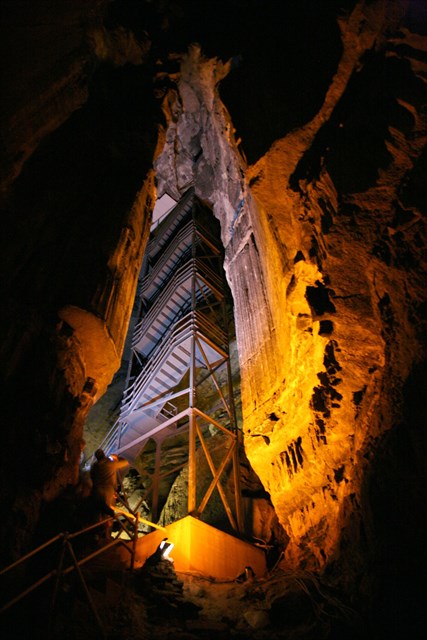
A. N37*10.980 W086*06.213 Mammoth Dome - This is a large sinkhole where ground water enters the cave system below. This area on the upper part of the ridge is some of the oldest cave formation. At the coordinates listed you will be standing close to a brown sign with three words on it. (1) What is the last word on the sign? (2) Make note of the altitude at this location
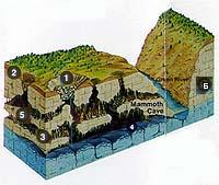
 This is what is under Mammoth Dome
B. N37*10.738 W086*06.551 Echo River - This is where the water exits the cave system and enters Green River. This area nearest to where the river exits the cave is some of the newest cave formations. At the coordinates listed you will be standing on a platform near a bench, looking at where Echo River exits the cave(1) How many boards including the seat and back make up the bench? (2)Subtract the altitude at this location from that of the Mammoth Dome location and send me the amount of drop from the top of the cave to the bottom
E-mail me your answers. There is parking close to both of these coordinates with a well defined trail to the location. The trailhead for the Mammoth Dome is in the back of the lodge near some older lodge rooms and the parking for Echo River is near the ferry parking area near Green River. To preserve the delicate ecosystem in the area please remain on the trail. A car is recommended to travel from one coordinate to the other.
If you enjoyed this Earthcache and would like to know about others, check out the below website.
Earthcache Listing