Skip to content

Catahoula Boulders Traditional Geocache

Hidden : 4/6/2005
Difficulty:
2 out of 5
Terrain:
3 out of 5

Size: Size:   small (small)

Join now to view geocache location details. It's free!

Watch

How Geocaching Works

Please note Use of geocaching.com services is subject to the terms and conditions in our disclaimer.

Geocache Description:


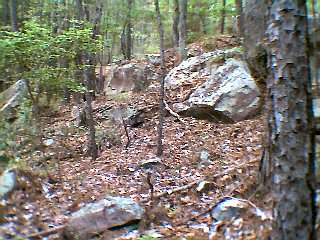
The Cathoula Formation -- formed some 35 million years ago during the Oligocene Period -- consists of buff-colored sandstone flecked with mica, quartzite, and trace amounts of uranium, all originating from volcanic ash. Deep within the Upland Island Wilderness Area, where the formation cuts across a ridgeline, nearby seeps have uncovered numerous rocks and large boulders. It's quite a rare sight for the Pineywoods of East Texas.

Your best bet for parking is along Forest Service Road 330, at the coordinates listed below. As you head towards the cache you'll skirt several bogs of carnivorous pitcher plants, along with sphagnum moss seeps. Watch your step lest you trample these environmentally sensitive areas.

Upon reaching the listed coordinates, you'll be looking for a camouflaged Nalgene bottle. Bring your own pen to sign the log. And be sure to take a few minutes (or hours) to explore the fascinating boulders strewn out amongst the longleaf pines.

Kid Friendly Kid Friendly Poison Plant Alert Thorns
Bicycles not permitted on paths Bicycles not permitted Less than 500 ft. from car Less than 500 ft. from car Snakes Snakes
Off-trail Hiking Required Off-trail Hiking Scenic View Scenic View No offroad vehicles No Offroad Vehicles
Pencil Bring a pen ticks Ticks mosquitos Wear bug repellant!
Parking Parking Lat: 31.03.145 Long: 94.20.564 ~ Mapquest
Texas Geocaching

Generated by The Selector

Additional Hints (Decrypt)

Unatvat jvgu Ubyyl.

Decryption Key

A|B|C|D|E|F|G|H|I|J|K|L|M
-------------------------
N|O|P|Q|R|S|T|U|V|W|X|Y|Z

(letter above equals below, and vice versa)