Large Tidal Bore waves are only found in the United States in upper Cook Inlet on Alaska’s southcentral coast. Turnagain Arm (just a few miles south of Anchorage on the Seward Highway) experiences the largest bore tides in North America, at rare times generating a wave up to six feet in height moving as fast as 15 - 20 mph. At other times the wave can be discernible while only being 18" in height. This cache introduces you to how the unique combination of topography and tidal range in Turnagain Arm produces this regularly observable event, seen nowhere else in the USA. Refer to Mount10Bike's log photo (above) to see an ideal example of a modest-sized tidal bore event.
This cache meets all current Earthcache Guidelines (effective Oct 16, 2005). All requirements including the mandatory observation photo have been approved by the Geoaware Reviewer.
This earthcache requires you to position yourself to observe the tidal bore along Turnagain Arm. Schedule your attempted observation time using the suggested event times provided in the link below. Your found-it log documenting your observation requires the following five items/answers:
1) You MUST post a photo of the wave to validate your observation.
2) Your log MUST include the local time of your observation.
3) Your photo coordinates MUST be posted as a waypoint in your log.
4) Include an estimate of tidal bore wave height and speed.
5) Do you think you could outwalk or outrun the wave?
No need to contact the cache owner - he'll review your posted log to ensure it complies. Each occurrence of this event is singularly unique in terms of size, speed, and timing - so don't hesitate to post your answers in your log - they won't 'give away' anything to future seekers of this geologic event!
Logs not meeting these requirements may be deleted without notice.
Click to view the 2024 Bird Point and Beluga Point Bore Tide Schedule - courtesy of the folks at the Girdwood.com website!
A tidal bore is a single wave generated by a sudden influx of water rushing in to an estuary following low tide. The prime ingredient for a tidal bore is a coastal tide range in excess of twelve feet. Turnagain Arm’s extreme tides are over 39 feet, the second largest range in the world after the Bay of Fundy in Nova Scotia. The length of Turnagain Arm coupled with its nearly-flat contour contributes to the large wave height, as the ‘slosh’ or resonance of the water flowing into the relatively shallow arm coincides almost exactly with the nearly twelve-hour frequency of tidal movement. The largest wave occurs during the periods of lowest tides. After low tide in Anchorage, the tidal bore should reach Beluga Point 1 1/4 hours later and Bird Point 2 1/4 hours later – give yourself plenty of time to get in place and ready yourself to witness a dramatic sign of the changing tide. Check the provided link (above) to know when you need to be on site - and be early!
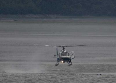
(Anchorage Daily News photograph by Scott Moran)
A State Trooper helicopter prepares to rescue a kayaker (in the water to the right of the helicopter) who was separated from his kayak in Turnagain Arm near Bird Flats July 29, 2007. The rapidly shifting tides propelled a wall of water called a bore tide his way, catapulting him from his boat in currents so strong they sucked the clothes off his body. The Trooper helicopter happened to be nearby on another call and retrieved the kayaker before he was swept all the way to Portage.
The currents here are not as benign as they look - stay out of the water! The silty mudflats act as a deadly kind of quicksand, trapping persons wandering onto the flats and holding them fast until they drown from the inrushing tide.
OBEY THE SIGNS - STAY OFF THE MUDFLATS!
Turnagain Arm is bordered directly by the Seward Highway on Anchorage’s south side, a designated National Scenic Byway with spacious pullouts positioned to provide dramatic vistas of the valley and upper Cook Inlet. This roadway makes possible a ‘chase’ of the tidal bore’s wave from pullout to pullout as it flows into the arm from west to east. A large and well-furnished wayside is at the promontory known as Bird Point. From here, it’s possible to see (and hear) the wave approaching from the west, and track its progress as it sweeps eastward into the upper reaches of the Arm. This accessible location is equipped with clean and spacious bathrooms, good parking for large vehicles, interpretive signs and exhibits detailing both the Tidal Bore and the beluga whale (commonly seen in Turnagain Arm during the summer months), and an excellent walkway out to an observation point with telescopes. As this is a part of Chugach State Park, there is a $5 parking fee to be paid within thirty minutes of your arrival. Bird Point is named for the flood of raptors and other travelers seen here during spring at this funnel point on the migratory flyway to the state’s Arctic region. This is listed as the cache location, but there are many other outstanding viewpoints along the Arm offering close looks at the Tidal Bore. You can log your find as found at any of these pullouts, as long as you provide a photograph in your log!
These recommended pullouts are in order from Anchorage towards Girdwood:
• Beluga Point – N61 00.395 W149 41.870 - This large turnout is a popular spot for sunset photography year-round and as a spotting site for beluga whales and Dall sheep. (No facilities)
• Windy Corner – N60 59.059 W149 36.608 - During the summer months windsurfers are sometimes seen here challenging chilly waters to take advantage of the steady wind. (No facilities)
• Bird Point – entrance to wayside at N60 55.825 W149 21.395 with best viewing at N60 55.688 W149 21.395. A paved pathway from here climbs up on the mountainside several hundred feet following the old roadway towards Girdwood, offering an easy hike with stunning views. Primary cache point with excellent facilities.
• Pullout – N60 56.205 W149 16.135 – This parking area is within feet of the water, and is my personal favorite for getting action shots of the kayakers and surfers who choose to challenge the Tidal Bore’s wave. A relatively deep but narrow channel close inshore that’s easy to reach draws these local extremists to this and several other pullouts between Bird Point and Girdwood in the summer months. Reserved Handicap Parking spots, good clear viewpoints close to the water and no parking fee makes this closer-to-Girdwood pullout an excellent choice relative to Bird Point - but there's no bathroom facilities here!
Click to view the 2024 Bird Point and Beluga Point Bore Tide Schedule - courtesy of the folks at the Girdwood.com website! This guide talks about both times and expected relative height of the wave.

Visit this site to learn more about the EarthCache concept (and how to earn the EarthCache Master Pin!):
The Geological Society of America (GSA) EarthCache Project