Fifteen to thirty feet beneath peninsular Florida's sandy soil is a
ten to twenty foot thick layer of phosphate rock. This part of the
state was once under the sea. Over millions of years, billions of
phosphate particles derived primarily from dead sea life settled
into layers with sand and clay. These layers were eventually
covered under sandy soil as the sea retreated.
Bone Valley is one of the world's most extensive mineable
phosphate reserves, covering 1.2 million acres (1,977 square miles)
in Polk, Hillsborough, Hardee, Manatee, and DeSoto Counties. Bone
Valley takes its name from the fossilized remains of more than one
hundred species that lived here millions of years ago. Sharks'
teeth, fossilized plant and animal life, and petrified shells and
corals are routinely uncovered during mining operations, and many
are preserved and displayed in the Museum galleries, along with
memorabilia and educational exhibits.
Phosphate mining in Florida dates back to 1881 and deposits
found in Alachua County, some 150 miles north of Mulberry. Mining
technologies have progressed markedly since that time, when picks
and shovels and eventually mule-drawn scrapers were used to break
apart the rock.
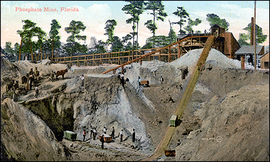
Phosphate Mining in Florida, circa 1910
Draglines were first used in the 1920s, and are still in use
today. These enormous machines strip off the top layers of earth to
reveal the phosphate. The phosphate is processed to separate the
valuable ore from sand and clay. The most visible by-products of
phosphate mining are gigantic phosphogypsum stacks, some reaching
500 feet tall. Several stacks are visible along State Road 60
between Mulberry and Bartow.
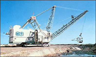
A Modern Dragline
Phosphate mining radically changes the landscape, and since the
1930s phosphate mining companies have become increasingly concerned
with land reclamation efforts. Reclaimed land is used for
agriculture, tree farms, wildlife habitats, lakes, general
recreation areas, and commercial and residential development. Many
of the area's parks are on reclaimed phosphate land, including
parks with geocaches: Saddle Creek Park, Tenoroc Fish Management
Area, and Edward Medard Park.
.................................................................................................................
The Mulberry Phosphate Museum is open Tuesday through Saturday
from 10:00am to 4:30pm, although the Earthcache can be completed
when the Museum is not open. A museum tour is highly recommended
(free, but donations are accepted); please thank the curator for
the Museum's support of this Earthcache. A large dragline bucket is
adjacent to the parking lot behind a load of mined rock. Museum
visitors are free to sift through the rock for fossils and sharks'
teeth.
To claim credit for this cache
1) Visit the Mulberry Phosphate Museum, and locate the
dragline bucket.
2) Have your photograph taken in front of the bucket with
your GPSr, so the bucket is visible. For solo cachers, a photo of
your hand holding your GPSr in front of the bucket is certainly
fine, as shown in the sample photograph.
3) Immediately before logging your find, e-mail the
answers to the following two questions
using this link. Do not post the answers in your
log!
Question 1 - According to the "Dragline Bucket" sign
adjacent to the Museum entrance, this bucket was manufactured in
the year _ _ _ _. The cost of the bucket new (in 1994 dollars) was
$ _ _ _ , _ _ _.
Question 2 - At N 27° 53.636 W 081° 58.372 (the
northeast corner of the parking lot) is a plaque marking the site
of the first experimental planting of citrus on reclaimed phosphate
mining land. The year was _ _ _ _, and _ _ _ _ _ _ _ _ _ _ _
_ _ _ _ _ _ _ originated and executed the project.
4) Upload your photograph(s) when you log your find. Logs
without at least one photograph will be deleted, hence the (albeit
modest) difficulty rating.
.................................................................................................................
Area Phosphate Sites
Visits to these sites are not required for the cache, but they are
included should you wish to further explore the Bone Valley
region.
|
|
Distance from Mulberry |
Fort
Blount Park, Bartow
Phosphate historical marker |
N 27° 53.808 W 081° 50.625 |
7.92 miles |
Curtis
Peterson Park, Lakeland
Reclaimed mining land |
N 27° 59.848 W 081° 56.747 |
7.36 miles |
Currently mined land, south of Mulberry
In this immediate vicinity |
N 27° 53.624 W 081° 58.392 |
2.98 miles |
For additional reading,
click
here for a page of phosphate-related links.