Português
A cache
A cache consiste num tupperware circular com cerca de 12cm de
diâmetro e envolvido num saco de plástico. O conteúdo inicial
inclui:
- Stashnote
- Logbook, lápis e afia
- Porta chaves tamanco holandês
- TB Traveling Light
O local
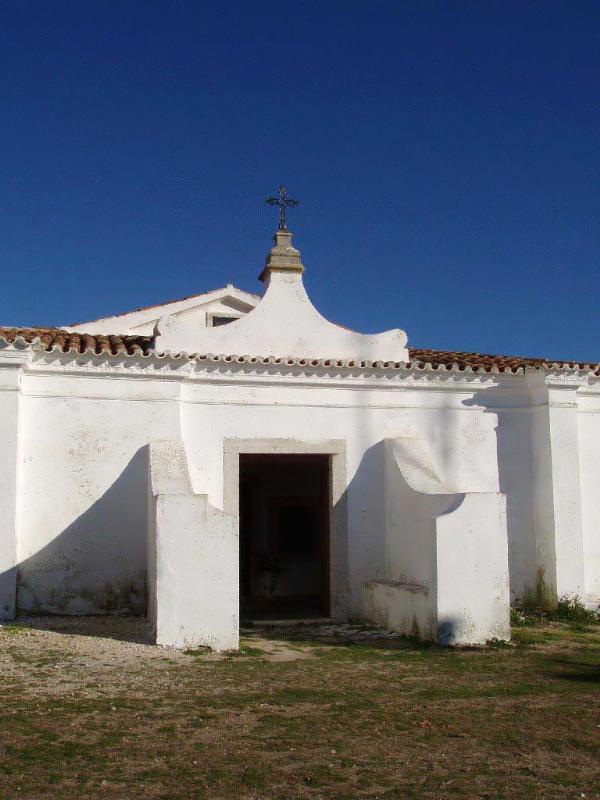
A capela que dá nome ao santuário localiza-se no ponto de
cumeada da Serra do Socorro, local onde anteriormente terá existido
uma mesquita, cujo acesso é permitido por uma caminho rural mas
perfeitamente acessível por carros. A vegetação existente resume-se
a arbustos de pequeno porte e a herbáceas que revestem o solo entre
a grande densidade de afloramentos rochosos que afloram à
superfície. Ao longo do caminho de acesso à capela, aproximadamente
no terço médio da encosta, existe um campo de jogos e um edifício,
sede da Associação Cultural e Recreativa de São Sebastião e um
Vazadouro de entulho, aparentemente inactivo. Local árido,
extremamente ventoso, oferece um domínio visual de grande alcance
sobre todos os quadrantes, dado ser o local topograficamente mais
elevado e pela ausência de vegetação de porte arbustivo ou
arbóreo.
Os dados apontam que existe uma ermida neste local desde 711
sendo que em 1147, D. Afonso Henriques mandou aqui erigir uma
ermida católica, pouco tempo depois da tomada da zona aos Mouros. A
capela está classificada como património nacional.
As vistas abrangem toda a costa Oeste de Peniche ao cabo da
Roca, a planície saloia, e a Serra de Montejunto a nordeste. A
serra do Socorro, constituída por uma chaminé basáltica rodeada de
rochas sedimentares, ergue-se isolada na planície e é ideal para
observar toda a zona envolvente.
A festa de Nossa Senhora do Socorro ocorre dia 5 de Agosto logo
provavelmente este não será um bom dia para procurar a cache.
Foi me dito recentemente que este monte era o principal ponto de
observação da primeira linha de Torres, complexo defensivo
construído para proteger Portugal das tropas Napoleónicas. Mas
brevemente surgirão mais informações sobre as linhas de Torres.
Como lá chegar
Circulando na Estrada Nacional 8 entre Torres Vedras e Malveira,
encontrarão um cruzamento para virar para Este para Enxara do
Bispo. A partir daí sigam as indicações para a serra do
Socorro.
English
The cache
The cache is a round tupperware about 12cm in diameter in a
plastic bag. Initial contents are:
- Stashnote
- Logbook, pencil and sharpner
- key ring
- TB Traveling Light
The Location
The chapel that gives the name to the sacntuary is located in
the top of the Hills of Socorro (Serra do Socorro), place where
there was an old moorish mosque acessible by a rural path but open
to cars. Local vegetation are just small bushes and grass like
vegetation among several rocky outcroppings. Along the way about a
third of the way up there is a football pitch and the builing which
houses the local cultural association. It is an arid and very windy
place with views to all directions since it is the highes spot in
the vicinity and because no high vegetation exists.
There is evidence that there was a refuge here since 711, but in
1147, D. Afonso Henriques, first king of Portugal, ordered a
catholic shrine erected here, shortly after conquering these lands
from the moors. The capel is classified as a national monument.
The views include all the West Coast from Peniche to Cabo da
Roca, the saloia plains and the Hills of Montejunto to the
northeast. The Socorro Hills are a basaltic chimney sorrounded by
sedimentary rocks and stands alone in the plain. Ideal to see all
the surroundings.
The feast of Our Lady of Socorro happens on the 5th of August so
this is probably not a good day to look for the cache.
I was recently told that this hill was the main observation spot
of the 1st line of Torres. The Lines of Torres were a defensive set
of forts and defenses designed to protect Portugal from Napoleon's
armies. But more will be available about the lines soon on
Geocaching.
How to get there
On National Road 8 (N8) between Torres Vedras and Malveira you
will find an intersection East to Enxara do Bispo. From there
follow the signs to Serra do Socorro.