
Visit the Geocaching Ireland discussion Forums
This Cache is placed in an Ammo box inside a black bin bag near the the top of a hill called Glannagilliagh. The cache location overlooks the beautiful Caragh (pronounce “Cara”) Lake (or Lough Cárthaí) between the villages of Killorglin and Glenbeigh in County Kerry, Ireland.
The easiest way up is if you walk back from the car park (N52° 03.74', W009° 50.22') and take the left fork at N52° 03.643' W009° 50.120'. Walk up the hill untill you come to a rocky/boggy path on the right that leads up towards the top.
It seems the access to the car park is currently blocked from the road and the walk is a little longer. Please try to find a safe plae for your car on the road.
Most of the forest on the easy way up has recently been felled and there is still some logging going on in the area.
It is still save and reasonably dry to go up there though - if you watch your step!
(In fact, if the barrier is open you can drive up some of the way if you dare.)
Alternatively you can follow the path leading up from the northern side of the car park. This route tends to be more wet under foot at most times though.
The last bit of the walk can be a bit (or very) wet in the winter and after heavy rainfall.
In those cases I strongly recommend waterproof boots!
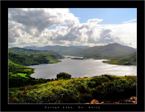
View from the cache over Caragh Lake
This area is known for its scenic beauty and the Ring of Kerry is a highlight of many a tourist’s visit to Ireland. Caragh Lake itself is a gem in Kerry’s crown and often passed by many tourists although it is only a short way off the main road. The lake was formed during the last ice age and lies between the McGillycuddy Reeks (the highest Mountains in Ireland) and Dingle Bay, "where Rossbeigh Beach invites you for a swim, amongst woodlands, blanket bog and heather clad hills".
From here you have a fantastic view all around you. Caragh Lake, Seefin Mountain and Glenbeigh to the West, Rossbeigh and Inch Beach and Castlemaine Harbour in Dingle Bay to the North, Killorglin, Killarney and Lough Leane to the East and the magnificent McGillycuddy Reeks to the South.