Kiparj Traditional Geocache
-
Difficulty:
-

-
Terrain:
-

Size:  (regular)
Please note Use of geocaching.com services is subject to the terms and conditions
in our disclaimer.
Tämä on Raatavuaran iha ensmäene tolokun keokätkö ja se olla möllöttää Kiparin vuaran piällä.
(Skip to English section)
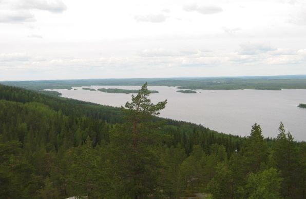
Kiparj hallihtoo Raatavuaran maisemoo. Vuaran piällä on näköalapaekka. Sinne piäsöö vanahoo kelekkaurroo pitkin, joka alakaa Keeritty - järven puoleesen tien varrelta. Kätkö ei oo muute hirveen kaakana rillikoasta, otaha mukkais makkaroo, jotta suat rillailla.
Täässinän raahan raja 1595 kuluki Raatavuaran kaatta. Kiparin laelta näk sillon niin Venäjälle kun Ruohti-Suomeen. Täässinän raaha ol savolaesille hirveen tärkee, koska siinä tunnustettiin Pähkinäsuaren raahan (1323) jäläkeen syntyneetten uuvisasutusten kuuluminen Ruohtin valtakuntaan. Uusj raja merkittiin muastoon tärkeemmille rajapaekoelle, mutta Täässinän raahan raja ehti olla valtakuntiin rajana vuan 22 vuotta. Yks vanaha rajamerkki sijaihtoo Kiparilta pohjoseen, Tiilikkajärven kansallispuistossa, toenen etelään Pisan huipulla.
Geocache Description in English:
This is the first cache in Rautavaara and it's located on the top of Kipari Hill.
Kipari Hill dominates the horizon in Rautavaara. The viewpoint on top of the hill can be reached along old sledge track. The routes start from the lake Keyritty side road. Cache is not far from fireplace, so take some sausages with you.
The border of the Täyssinä Peace Treaty went through Rautavaara. From the top of Kipari it was possible to see both great powers, The Russia and Sweden-Finland. The Täyssinä peace meant a lot for people in Savo, because it ackowledged that the settlements that were established after Pähkinäsaari Peace in 1323 belong to Sweden. The new border was marked in the most important places, but this border last only 22 years. One of the old border markers is located north from Kipari, in the national Park of Tiilikkajärvi and the other south from Kipari, in the top of Pisa Hill
Additional Hints
(Decrypt)
[Suomeksi:] Xbybffn, rv zvffääa ybxbfrffn, xvirazhevxna nyyn.
[In English:] Va gur ubyr, haqre gur fgbar.