From what little we've been able to learn, Fred
Haught was a man who grazed cattle in this area. We haven't even
been able to find out the approximate time frame that he was here.
Regardless, there's now Fred Haught Ridge, Fred Haught
Canyon, Fred Haught Spring, and Fred Haught Trail
named after the man.
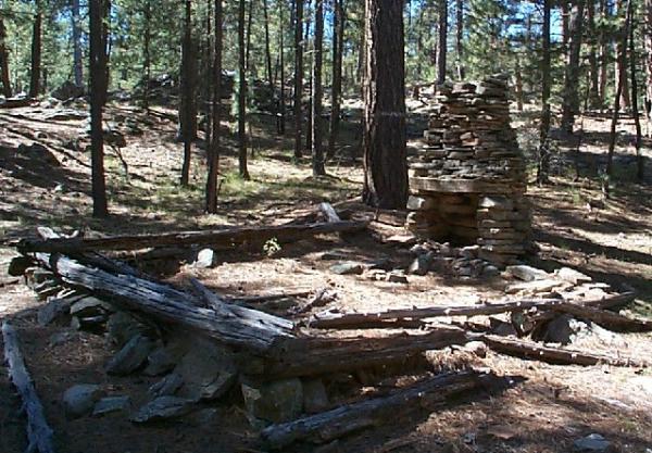
Little remains of his cabin except for a few
timbers and his chimney. Come and check it out, but leave
everything just as you found it. The cache is not right at the
cabin site, but is located a respectful distance away.
The best access involves a 1/2 mile hike one way
through some nice forest. The hike down is pleasant and not too
strenuous. The cache earns its terrain rating of 3.0 on the way out
because you have to go back uphill.
Get yourself onto Forest Road 95 from the north
or south end, whichever you prefer. Navigate to the turnoff to road
719. This intersection is at coordinates N34° 29.183' W111°
12.324'. Follow road 719 as it travels west, then north to
parking at N34° 29.527' W111° 13.281'. Before you get to the
parking area, you will find yourself very close to the cache
location, but don't be tempted to stop short of the recommended
parking spot. The descent from the closest point on the road is
very steep.
At the parking location, you will find a nice
trail descending to the south. This is the Fred Haught Trail, part
of the Cabin Loop Trail. You are actually about at the mid-point of
Fred Haught Trail as it also continues northward. After about a
quarter mile of hiking down this trail, you will come to a sign
with an arrow that says, "FRED HAUGHT CABIN .5 MILES". Don't
believe it, you are only about a quarter mile away at this point.
This is where you will turn and leave the trail. His cabin is not
on the trail.
While the trail will now head westward, you will
turn south, going up-creek into Fred Haught Canyon. As you leave
the trail, you will be crossing Fred Haught Spring. A good place to
cross the water is just past the sign about 20 yards. Once you get
across the water, just follow your GPS to the cache.
By the way, if you were to continue on the
trail, instead of turning toward the cabin, you would soon
intersect the Arizona Trail. From this trail intersection south to
the Rim, the Fred Haught Trail, the Cabin Loop Trail, and the
Arizona Trail are all names for the same footpath.