 |
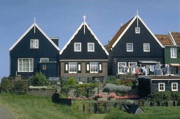
In de 13e eeuw werd
Marken door een zware storm gescheiden van de rest van
Noord-Holland. Pas in 1957 werd een dijk aangelegd die Marken weer
met het vasteland verbond. Marken is beroemd om haar traditionele
klederdracht en haar kleine huisjes vol met porselein en andere
ornamenten. |
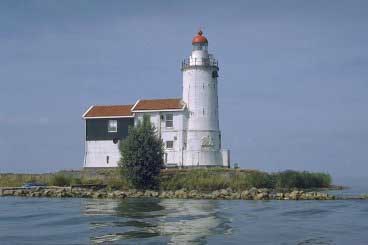
| Eens was Sijtje Boes met
haar souvenirwinkel onbetwist de trekpleister. De vuurtoren Het
Paard van Marken herinnert aan de voormalige vissersvaart van
Marken en is welhaast het bekendste en meest gefotografeerde
bouwsel van de voormalige Zuiderzeekust. De oorspronkelijke toren
aan het einde van de strekdam dateert van 1700. |
 |
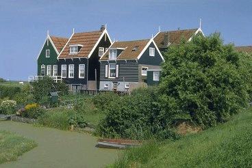 |
Veel huizen zijn op
werven en op palen gebouwd, als voorzorg tegen de overstromingen
die het eiland regelmatig teisterden toen het IJsselmeer nog
Zuiderzee was. Vooral in de winter, als stuwend ijs het eiland
siert, biedt Marken een spectaculaire aanblik. |
| Op Marken mogen alleen de
eilandbewoners met motorvoertuigen rijden. Alle bezoekers moeten
parkeren op het parkeerterrein, dat op bovengenoemde coördinaten te
vinden is. Parkeren kost ongeveer € 5,00. |
 |
Marken is per openbaar vervoer bereikbaar met Arriva bus 111 vanaf
NS-station Amsterdam Centraal (2x per uur op weekdagen, 1x per uur
in het weekend en op feestdagen). Per auto via de ringweg Amsterdam
A10-noord, afslag S116. Volg de borden richting Marken.
Gratis parkeren kan alleen buiten Marken. Langs de toegangsweg naar
Marken (rijksweg N518) zijn kleine parkeerplaatsen waar u (voor
eigen risico) gratis kunt parkeren. Ze zijn te vinden bij de
hectometerpalen:
- 11,0 (N 52°26.113 - E 005°05.389)
- 11,9 (N 52°26.590 - E 005°05.643) en
- 12,4 (N 52°26.836 - E 005°05.676).
De eerste is de grootste, de andere zijn klein. De laatste is het
dichtstbij (ongeveer 1300 meter naar het
parkeerterrein).
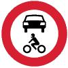
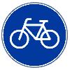
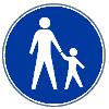
De
drie belangrijkste verkeersborden op Marken zijn:
 |
 |
 |
| Motorvoertuigen zijn hier niet
toegestaan |
Volop fietsgelegenheid... |
...en een heerlijk wandelgebied! |
Parkeer de auto op het parkeerterrein met bovengenoemde coördinaten
of op een van de gratis parkeerplaatsen. Loop vervolgens naar de
haven:
N 52°27.481 - E 005°06.049
Onderweg komt u langs de woningen van de buurtschappen Kets en
Havenbuurt. Bij veel van deze oorspronkelijke paalwoningen zijn de
palen inmiddels vervangen door een extra woonlaag.
Waarschijnlijk zult u in dit deel van Marken ook een aantal
toeristen tegenkomen. Later tijdens deze zoektocht zal het
ongetwijfeld veel minder druk zijn en kunt u nog meer genieten van
de rust van Marken.
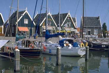
In de haven kunt u lekker eten. Er zijn een paar restaurants en
natuurlijk een viskraam. Ook richting Kerkbuurt komt u enkele
eetgelegenheden tegen.
Eén van de gebouwen in de haven behoort tot de reddingsbrigade
K.N.R.M. In de dakpannen van het gebouw zijn drie letters zichtbaar
gemaakt. Deze letters vormen antwoord A.
De letters zijn:
- KRM: A = 1
- SRM: A = 2
- SMR: A = 3
- MRK: A = 4
Huisnummer 19C geeft antwoord B.
In de onderverdieping vindt u:
- het kantoor van de havenmeester: B = 1
- toiletten en douches: B = 2
- een souvenirwinkel: B = 3
- een visrestaurant: B = 4
Loop
vervolgens naar het eind van de zuidpier:
N 52°27.502 - E 005°05.955
Hier
staat een bord waarop is aangegeven wat u hier niet mag doen. Dit
is antwoord C.
U mag hier niet:
- duiken vanaf de pier: C = 1
- vissen vanaf de pier: C = 2
- een boot aanleggen: C = 3
- naakt recreëren: C = 4
Loop
verder naar:
N 52°27.60C - E 005°06.ACC
Dit
is een brug. Alle bruggen in dit deel van Marken zijn genoemd naar
leden van het Koninklijk Huis. Dit is antwoord D.
Deze brug is genoemd naar:
- Koningin Beatrix: D = 1
- Koningin Juliana: D = 2
- Koningin Wilhelmina: D = 3
- Prinses Máxima: D = 4
Ga
nu naar:
N 52°27.6BB - E 005°06.A86
Dit
is het plaatselijke museum, geopend van april t/m oktober. Eén van
de huisjes van het museum is ingericht zoals een Marker
visserfamilie er vroeger woonde.
F = het jaar tot wanneer deze familie er
woonde
U
gaat nu naar de werven. Loop naar:
N 52°27.(F-1647) - E 005°06.(F-1121)
U
zult eerst bij Grotewerf komen en vervolgens bij Rozenwerf. Schroom
niet om eens tussen de huizen door de kleine steegjes te lopen
(maar respecteer de privacy van de bewoners).
Bij Rozenwerf ligt in het IJsselmeer een aantal ijsbrekers. Deze
moeten de huizen van Rozenwerf beschermen tegen kruiend ijs
(ijsschotsen).
G = het aantal ijsbrekers
Vervolg uw weg naar:
N 52°27.((F/A)-115) - E 005°07.(G+A+700). Let goed op de
nummers van de witte paaltjes die u onderweg tegenkomt.
H = het nummer van het witte paaltje bij deze
coördinaten
U
zult inmiddels wel begrijpen wat uw volgende bestemming is: het
Paard van Marken. Loop naar de aanwijzing bij:
N 52°27.(600+(H-B)) - E 005°08.((F/6)-((HxB)+17))
J = het aantal heldere seconden van het
licht
U
kunt nu op zoek gaan naar de cache. Deze bevindt zich bij de
volgende coördinaten:
N 52°(A+B+D+G+J).((G+H)x(AxA))+(Hx(J-C)) - E
005°07.((Hx(J+A))-G)
De cache ligt vlakbij de openbare weg, dus als uw coördinaten
midden in het weiland uitkomen hebt u een fout gemaakt. Het is in
principe niet meer noodzakelijk om over het hek te klimmen om de
cache te pakken. Dek de cache na afloop weer goed af, want de
beschutting is tegenwoordig nog wat weinig (er is nl. flink
gesnoeid).
Veel
succes!
Heeft u nog wat tijd over en wilt u eens de grootste rust van
Marken voelen, loop dan eens over de Bukdijk. Dit loze eind
richting Volendam (3,5 km heen-en-terug) is het resultaat van de
werkverschaffing uit de jaren dertig. Het is een uniek
natuurgebied. Winterkoning en koekoek broeden er, aalscholvers
komen er in de nattige herfst tot diepzinnige gedachten en tussen
het hoogopgeschoten gras overleeft een plukje kruisdistel nog
steeds ook al is het IJsselmeer al lang niet zout meer. De Bukdijk
is te vinden in het uiterste noorden van Marken en begint
bij:
N 52°28.057 - E 005°06.165
* * * * * * *
Bezoek ook de andere caches uit de Waterland-serie:
Waterland cache 2: Broekje
Waterland cache 3: Het Norbertijnendorp
Waterland cache 5: Landelijk Noord

This is the first of the number of caches
in the Waterland area. A 7 km walk on the former island of
Marken.
Due to a heavy storm in the 13th
century Marken was separated from the rest of the province of
North-Holland. In 1957 a dike was build to connect the island with
the mainland. Marken is famous for its traditional costumes and its
small houses with procelain and other ornaments.
Once the main attraction was mrs. Sijtje Boes with her souvenir
shop. The lighthouse Het Paard van Marken (the Horse of Marken)
recalls to the former fishery of Marken and is the most famous and
most photographed building on the coastline of the former Zuidersea
(now IJsselmeer or IJssel lake). The original tower on the end of
the breakwater dates back to 1700.
When the IJsselmeer still was Zuidersea frequently floods swept the
island. Many houses are build on wharfs and on piles, as a
precaution against the floods. Mainly in wintertime, when drifting
ice appears, Marken offers a spectacular view.
On Marken only the inhabitants are allowed to drive cars. All
visitors must park their car on the main car park, which can be
found on the above mentioned coordinates. Parking here will cost
you about € 5,00.
You can reach Marken by public transport as well. Take Arriva bus
111 at Amsterdam Central Station (2 times per hour on weekdays, 1
time per hour on weekends and public holidays). By car: take exit
number S116 on the ring motorway of Amsterdam (A10-noord) and
follow the signs for Marken.
Free car parks are only outside of Marken. Along the access road to
Marken (highway number N518) there are some lay-bies where you can
park at your own risc. You can find these near the hectometre
signs:
- 11,0 (N 52°26.113 - E 005°05.389)
- 11,9 (N 52°26.590 - E 005°05.643) and
- 12,4 (N 52°26.836 - E 005°05.676).
The first one is the biggest, the others are small. The last one is
closest to the island (about 1300 meter to the main car
park).
The three main traffic signs on Marken are: no cars or motorbikes,
many bicycle and hiking possibilities.
Park your car at the main car park,
which can be found on the mentioned coordinates or at one of the
lay-bies. Now walk to the harbour:
N 52°27.481 - E 005°06.049
On your way you will see the houses of
the Kets and Havenbuurt quarters. The piles of the most houses are
replaced by an extra storey. In this part of Marken you will
probably meet some other tourists.
There are some restaurants in the harbour and of course a fish
stall. In the direction of Kerkbuurt you will find a few more
eating places.
One of the buildings in the harbour area belongs to the lifeguards
of K.N.R.M. In the tiles on the roof three letters are visible.
These letters are answer A.
The letters are:
- KRM: A = 1
- SRM: A = 2
- SMR: A = 3
- MRK: A = 4
House number 19C gives answer
B.
In the lower storey you can find:
- the office of the havenmeester (harbour master): B = 1
- toilets and showers: B = 2
- a souvenir shop: B = 3
- a fish restaurant: B = 4
Now walk to the end of the south
pier:
N 52°27.502 - E 005°05.955
Here is a sign that shows what you are
not allowed to do. This is anwer C.
You are not allowed to:
- dive from the pier: C = 1
- fish from the pier: C = 2
- moor a boat: C = 3
- walk naked: C = 4
Walk on to:
N 52°27.60C - E 005°06.ACC
This is a bridge. All bridges in this
part of Marken are named after a member of the Dutch royal family.
This is answer D.
This bridge is named after:
- Queen Beatrix: D = 1
- Queen Juliana: D = 2
- Queen Wilhelmina: D = 3
- Princess Máxima: D = 4
Now go to:
N 52°27.6BB - E 005°06.A86
This is the local musem, opened from
April till October. One of the houses of the museum is furnished in
the style of the fishing family who once lived
there.
F = the year when this family
stopped living here
Now you go to the wharfs. Walk
to:
N 52°27.(F-1647) - E 005°06.(F-1121)
You will first see Grotewerf (big or
large wharf) and then Rozenwerf (wharf of roses). Do not hesitate
to walk through the tiny alleys (but respect the privacy of the
inhabitants).
In the IJsselmeer, near Rozenwerf, there is a number of
ice-breakers. They have to protect the houses from the ice creeping
over the dike.
G = the number of ice-breakers
in the water
Continue to:
N 52°27.((F/A)-115) - E 005°07.(G+A+700). Have a good look
at the numbers on the small white poles on your way to this
point.
H = the number of the pole at
these coordinates
Now you probably know what your next
destination will be: the Horse of Marken. Walk to the pointer
near:
N 52°27.(600+(H-B)) - E
005°08.((F/6)-((HxB)+17))
Unfortunately the information here is
only in Dutch. Find the answer with the help of the following
text:
J = "... seconden helder, 2 seconden duister" (the number of
clear and dark seconds of the light.) Replace the dots with
J.
Now you can find the cache. It is
hidden near the following coordinates:
N 52°(A+B+D+G+J).((G+H)x(AxA))+(Hx(J-C)) - E
005°07.((Hx(J+A))-G)
The cache is hidden near the main road. You have made a mistake if
your coordinates point to somewhere in the middle of the meadows.
It is not necessary to climb over the fence.
Good luck!
If you have some spare time left and you want to feel the ultimate
rest of Marken than you must walk the Bukdijk (Buk dike). A 3,5 km
walk (coming and going). It is a nature reserve, where you can see
many birds and plants. The Bukdijk starts in the most nothern part
of Marken, near:
N 52°28.057 - E 005°06.165