From Riches to Ruins (Oxon) Multi-Cache
From Riches to Ruins (Oxon)
-
Difficulty:
-

-
Terrain:
-

Size:  (regular)
Please note Use of geocaching.com services is subject to the terms and conditions
in our disclaimer.


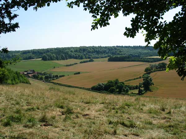
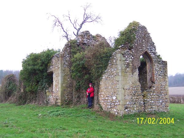
'The chiltern way' & local trails will take you on a circular walk around the 'Stonor Estate' which yields panoramic views of Stonor House & the Disused St.James church in Bix Bottom. Make sure you bring a camera along for the ride.
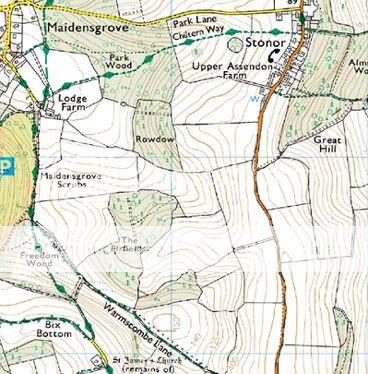 This cache is a 6 part multi covering a circular route running from Stonor, passing by Maidensgrove, moving onto Bix Bottom where you will find the disused & overgrown St.James Church & then back upto Stonor where refreshments can be found, please also take some drinks with you along the way as the trail is undulating & you may need them! After finding the final cache a road walk of around a mile will complete your treck, either that or return the way you came, just so you are pre-warned. Stonor is the home of Lord & Lady Camoys who inhabit Stonor House. Much of the land in this area is part of the Stonor estate & you are sure to see signs making this clear throughout your journey. the land has been in their possesion for atleast 800 years, so please stay on marked trails. In the grounds of the house a reconstruction of a stone circle can be seen, which is something else to look out for when entering park wood which we will come to. The 5 parts of this cache prior to the cache itself are all virtuals which should not be too difficult to find. Please take a copy of this page with you as you may need its help along the way. The coords which are printed on the page will take you to our first location, you should attempt to park somewhere near here but thats upto you. Now if you are ready, it's time to begin...
Location 1: Use coords at the top of this page
You should find yourself on the main Stonor Road close by a footpath sign pointing to Maidensgrove. This is the trail which you should take to begin your walk. Whilst here make a note of how many miles it is to this location, The answer = A. Now follow the footpath directly infront of you up the slope, over the stile & past some local cows who may or may not be there, until you reach a stile entering Park wood.
Location 2: N51°35.478 W000°56.862
You should now be at the top of a long slope with fine views over the village. From here you can see Stonor House which is the large building slightly to the left behind the main dwelling. On the gate ahead of you are a number of small signs for the 'Chiltern Way' but exactly how many are there?The answer = B. Continue to follow the footpath through the woods until you reach another stile. Cross it and enter the field heading directly accross this aswell. Soon lodge farm will be in view. Follow the footpath signs to a mini grass roundabout & take the first exit left.
Location 3: N51°35.301 W000°57.457
At these coords you will find yourself at the entrance to the 'Warburg Nature Reserve'. We will not be entering this, however you will need to make a note of the final digit from the telephone number. The answer = C. Staying on the original path head along the outskirts of the wood until you reach a fork in the path.
Location 4: N51°35.000 W000°57.470
At the fork stop for a second. Under an arrow which points left there are 2 numbers which are the same. What number is this? The answer = D. Now take the right hand path which runs slightly downhill all the way down to the road & Bix Bottom where you will instantly notice the ruins of St.James Church.
Location 5: N51°34.608 W000°57.200
The coords will take you to the grassy area surrounding the church. According to some information which I have dug up this long forgotten chapel has been used in atleast 1 horror movie in recent years. It is also home to pagan rituals & from markings inside it is easy to see it's regularly visited. Used until around 1875 it is believed that the old village around the site was destroyed after the inhabitants died due to an outbreak of disease, possibly plague. Make your way inside through the obvious doorway & head for the middle arch. To the right of the arch many people have inscribed their names on the stone. Just to the right of where Alex, KV & SP marked their visit there is an obvious date, please complete it for your final digit - 24/8/E6.
You have now completed all the tasks needed to create your final set of coords. Please use the ones below, exchanging the letters with the correct digits:
N5A°D4.(C+1)4D W0(A-1)0°5(E-1).(A-1)DB
The final resting place will supply you with a fantastic view of the church & will also take you some of the way back towards your car, infact after finding it simply follow the footpath until it meets the road, turn left & after a short walk your car should be in sight. Have a great time finding the cache & please post any photos you take on this page so everyone can see them. Please replace the cache box so that it is obscured from all directions, you will see why when your there. If your not willing to put some effort in at this point, I would rather you just left it hidden and just logged online, this is still a find, it's just it will be very obvious if its just pushed back into place. Cheers, Dan.
Additional Hints
(Decrypt)
Pyvzo gur gerr!