This is an Earthcache – as such, there is no physical cache. Instead after examining the land around the “porous pavers” at the posted coordinates you will answer 4 questions and message me the answers you can log the find.
While I was attending one of the Annual Bike Trail events, one of my geocaching friends brought me here to show me a perfect spot for an earthcache. I was intrigued, until I saw it was based on a sign that reads You Are Standing on Pourous Pavers!
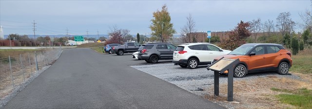
The sign at the posted coords reads "This 800 square foot porous parking lot in front of you has been finished with an environmentally friendly permeable surface that allows stormwater and snow melt to pass through and absorb naturally back into the ground." There is a bunch more stuff on that sign about how stormwater management works, and how the porous pavers work, and water quality. All interesting things, but nothing on this sign will help much with this earthcache as I was more interested in why it was installed here at this location.
Looking around I see that we are on the bottom of a sloped road. When rain falls on natural slopes covered by healthy vegetation, the plants and soil absorb and slow down some of this water. Looking around some more I observed that there is a lot of exposed dirt without vegetation. Sometimes development on steep slopes often disrupts these natural functions and results in more runoff, faster runoff, and less protection for the soil. All that concentrated high energy stormwater flow causes erosion, washouts, and land creeps, and landslides. Increased peak flows cause flood damage to homes and infrastructure.
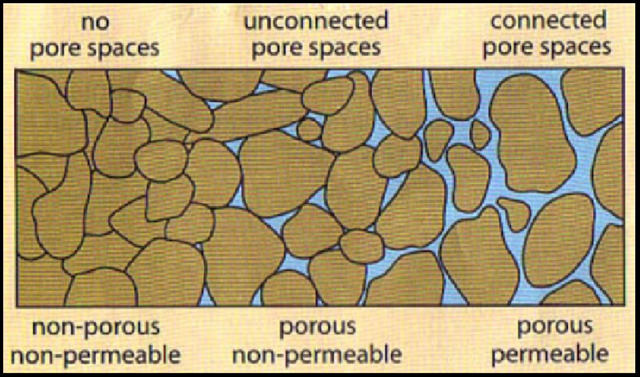
To be POUROUS means to have small spaces or holes through wich liquid or air can pass. Porosity is the pore space in soil between mineral particles (and solid organic matter) filled with either air or water. The pore space both contains and controls most of the functions of soil.
When water doesn't absorb into the soil, it tends to flow over it This tends to cause erosion, as the moving water dislodges and transports soil and rock further away. In terms of stormwater, erosion most often refers to stream bank erosion, where rapid water flows cut away at the edges and bottoms of stream banks and transport soil downstream.
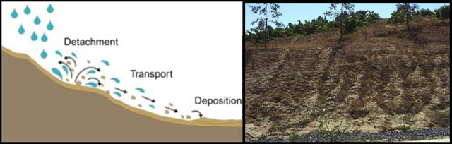
Here erosion can be seen in the un-grassed areas along around the parking area, bike trail, and Route 9. I see some small signs of Rill Erosion (example in above right photo), a type of erosion that occurs as water flows over a hillslope and cuts shallow, curvy channels into the topsoil. Looking around I also see what could also be land creep. In geology, a creep slow downslope movement of particles that occurs on every slope covered with loose, weathered material.
According to the General soil map of Berkeley County, West Virginia pictured below, this permious parking area was constructed in the purplish WEIKERT-BROOKS-CLEARBROOK series of soils.
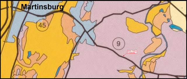
The WEIKERT-BROOKS-CLEARBROOK is not a single series of soils, but they are the three major soils located in that area:
•BERKS SERIES: Berks series consists of moderately deep, well YELLOWISH drained soils formed in residuum weathered from shale, siltstone and fine grained sandstone on rounded and dissected uplands. Well drained. The potential for surface runoff is negligible to high.
•WIEKERT SERIES: The Weikert series consist of shallow, well drained soils formed in material that weathered from interbedded GRAY and BROWN acid shale, siltstone, and fine-grained sandstone on gently sloping to very steep areas on uplands. Well drained. The potential for surface runoff is negligible to high.
•CLEARBROOK SERIES: The Clearbrook Series consists of moderately deep, somewhat poorly drained soils formed in material weathered from ACID GRAY shale and sandstone. They are nearly level to moderately steep soils on uplands. The mean annual precipitation is about 38 inches. Well drained. The potential for surface runoff is negligible to high.
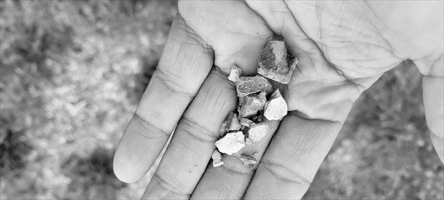
As you can see from my handful of sediment that the top layer is very rocky, but the solid dirt underneath has a pretty unified color, but neither soil texture nor color alone are reliable clues to permiability. All three soil types are described as having a Permeability "that is moderate or moderately rapid," but only one is listed as being "well drained." So a heavy gush of water would overwhelm the natural soils and "roll over it" as storm water run off. It stands to reason that these permious pavers are designed to take in a larger amount of water at a quicker rate, hence reducing the amount of storm runoff and errosion to this area of the bike trail.
LOGGING REQUIREMENTS:
To log this Earthcache: Read the geology lesson above. Answer all four questions posted below and post photo. Answers can be sent via e-mail or messenger contacts on my Geocaching profile. Group answers are fine, but do not post the answers to the questions in your logs.
QUESTION 1. What does it mean to be porous?
QUESTION 2. What is the major source of storm water run off that makes this spot a great place to install a porous parking pad?
QUESTION 3. Of the exposed soils that you can see in the grass, which of the three soil series listed do you believe this soil to be?
QUESTION 4. Walk over to stage 2 and look at the bottom of the fence posts. In your opinion, are the concrete molds that hold the posts in place exposed from storm water erosion or from soil creep?
OPTIONAL PHOTO: Posting a photo in your log readily indicates that you (and anyone else logging the find) are at the location.
 Awesnap has earned GSA's highest level:


REFERENCES
1. General soil map, Berkeley County, West Virgina Morgantown, W.Va State Conservationist, distributor, 1999, loc.gov
2. Weikert Series Established Series, Rev. GHL-EAW-REP, 09/1999, soilseries.sc.egov.usda.gov
3. Berks Series Established Series, Rev. GHL-EAW-REP, 09/1999, soilseries.sc.egov.usda.gov
4. Clearwater Series Established Series, Rev. GHL-EAW-REP, 09/1999, soilseries.sc.egov.usda.gov
5. The permeability of soils explained Kasia Zamara, on November 17, 202, tensar.co.uk
6. You Are Standing on Pourous Pavers! Posted Sign,