Skip to content

Ziemeļu forti Multi-cache

Hidden : 3/9/2022
Difficulty:
2 out of 5
Terrain:
1.5 out of 5

Size: Size:   small (small)

Join now to view geocache location details. It's free!

Watch

How Geocaching Works

Please note Use of geocaching.com services is subject to the terms and conditions in our disclaimer.

Geocache Description:


Šis slēpnis ir daļa no klimata spēles ClimateQuest, kopā paslēpti 43 dažādi slēpņi 8 Eiropas valstīs. Latvijā ClimateQuest spēle aizvedīs uz interesantām vietām un iepazīstinās ar klimata un dabas saistītiem jautājumiem.

Pārējos var atrast Bulgārijā, Čehijā, Rumānijā, Ungārijā, Vācijā, Slovākijā un Lietuvā.

Lai izpildītu visu klimata spēli ClimateQuest Latvijā tev pavisam būs jāatrod seši slēpņi.

Lai atrastu “Ziemeļu forti” slēpni, tev jāapmeklē norādītie pieturas punkti, jāatbild uz uzdotajiem jautājumiem un jāatrisina uzdevums, noskaidrojot slēpņa gala koordinātes.


STAGE 1

Tava spēle sāksies šeit: N 56 35.483  E 021 00.946

19. gs. beigās, lai pasargātu Liepājas jūras kara bāzi ienaidnieka uzbrukuma gadījumā, Krievijas ķeizariskā kara flote izbūvēja nocietinājumus tagadējās Karostas teritorijā, no kuriem vislielāko ievērību izpelnījušies tieši Ziemeļu forti.

Savam tiešajam mērķim forti tā arī nekad nav kalpojuši. Nepilnus desmit gadus pēc to izbūves – 1908. gada novembrī – Liepājas cietoksni likvidēja, jo atzina, ka tā celtniecība bijusi stratēģiska kļūda. Daļu lielgabalu demontēja un aizveda uz Kauņas cietoksni Lietuvā, daļu pārkausēja. Lai iznīcinātu nocietinājumu, tā būves tika divas reizes spridzinātas, bet arī tā pilnībā tās neizdevās iznīcināt. Līdz mūsdienām saglabājušās līdz galam nesaspridzinātās artilērijas baterijas un pazemes būves, kuras veido Karaostai tik pazīstamo tēlu un kalpo kā vilinošs tūrisma objekts.

Jautājums:

Vērtību „A“ atklāsi, noskaidrojot balto burtu skaitu sarkanajā taisnstūrī.


STAGE 2

Tālāk dodies uz N 56 35.474  E 021 00.915

Jautājums:

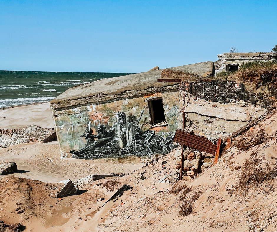
Vērtību „B“ atradīsi, ja saskaitīsi, cik lielformāta grafiti redzami šajā vietā.


STAGE 3

Dodies uz N 56 35.324  E 021 00.803

Visā krasta posmā no Liepājas ostas ziemeļu mola līdz Laikām (aptuveni 25 km kopgarumā) dominē krasta erozija. Tostarp aptuveni 8 km garā krasta posmā uz ziemeļiem no mola krasta eroziju būtiski pastiprina antropogēns traucējums – Liepājas ostas ārējo hidrotehnisko būvju radītais garkrasta sanešu apmaiņas traucējums.

Jautājums:

Sameklē vērtību „C“, saskaitot, cik "stāvu" ir krastā esošajam betona aplim, kas līdzinās "tortei".


STAGE 4
Tagad meklē ceļu uz
 N 56 35.289  E 021 00.763

Vidējais krasta atkāpšanās ātrums tieši uz dienvidiem no Ziemeļu fortiem sasniedz 1,5 m gadā (tas nozīme, ka pēdējo 50 gadu laikā krasts ir atkāpies par 50–100 m, atkāpšanās nenotiek katru gadu, bet tikai stiprākās vētrās, vienā ļoti stiprā vētrā krasts var atkāpties par 10+ metriem).

Krasta iecirknī atkāpšanās ātrums ir viens no straujākajiem Latvijā. Atkāpšanās iemesls  –  cilvēkfaktoru radīts smalko sanešu deficīts krasta sistēmā  –nozīmē, ka Liepājas ostas ārējās hidrotehniskās būves pilnībā pārtrauca smilšu ceļošanu uz ziemeļiem (kā tas notika vairākus iepriekšējos tūkstošus gadu) un izjauca līdzšinējo stāvokli, kas izpaudās lielā erozijā.

Jaurtājums:

Vērtību „D“ noskaidro, saskaitot, cik skrūvju iebetonētas apļveida objektā.

Kad esi atradis visas vērtības, Tev ir jāatrisina formulas.

Kontrolsumma A+B+C+D=56

C*D=EFG
(A+B+C)-D=H
A/C=J
(A+C-D)/B=K

Slēpnis atrodas N 56 KJ.JH9   E 021 GE.GJ6


This cache is part of a ClimateQuest series - 43 caches across 8 states in Europe. In Latvia, caches will take you to interesting places and will provide information on matters related to climate and nature.
Rest of them, you can find in Bulgaria, Czechia, Romania, Hungary, Germany, Slovakia and Lithuania.
To complete the entire ClimateQuest series in Latvia, you’ll need to find a total of six caches.

In order to find out the coordinates of the "Northern Forts" cache, you need to visit the indicated locations, answer the questions, and solve the task.


STAGE 1
Your quest starts here: N 56 35.483 E 021 00.946

At the end of the 19th century, to protect the Liepāja naval base in case of attack, the Imperial Russian Navy built fortifications in the territory of modern-day Karosta, of which the Northern Forts have earned the most attention.

The forts have never served their original purpose. Almost ten years after the construction – in November of 1908 – the Fortress of Liepāja was destroyed, as it was acknowledged that its construction had been a strategic mistake. Some of the cannons were dismantled and taken to the Kaunas Fortress in Lithuania; others were melted down. The constructions of the fortress were detonated twice to take it down, but it wasn’t possible to destroy it completely. Nowadays, it’s still possible to visit the artillery batteries and underground structures that are part of the unique character of Karosta and serve as an enticing tourist attraction.

Question:

You’ll find out value „A“ by counting the white letters in the red rectangle.


STAGE 2

Proceed to N 56 35.474 E 021 00.915

Question:

You’ll find value „B“ by counting how much large-format graffiti can be seen here.


STAGE 3

Proceed to N 56 35.324 E 021 00.803

The entire shore section from the Northern Breakwater of the Port of Liepāja to Laikas (approx. 25 km) is dominated by coastal erosion. Moreover, coastal erosion is intensified in the shore section of approx. 8 km to the north from the breakwater due to an anthropogenic disturbance – disruptions in coastal sediment exchange caused by the external hydrotechnical constructions of the Port of Liepāja.

Question:

Find value „C“ by counting how many “levels” there are in the concrete ring (that resembles a “cake”) located on the shore.


STAGE 4

Now, head over to N 56 35.289 E 021 00.763

The average speed of coastal erosion right to the south from the Northern Forts amounts to 1.5 metres per year (this means that over the past 50 years 50–100 metres of the shore have been lost; the shore doesn’t recede every year but only during larger storms – during one big storm, the shoreline can lose 10+ metres).

The coastal section has one of the fastest erosion rates in Latvia. The reason for this is the man-made deficit of fine sediment in the coastal system – the external hydrotechnical constructions of the Port of Liepāja have completely halted the movement of sand to the north (as it was happening for several thousand years) and have disrupted the previous state, thus resulting in extensive erosion.

Question:

Find value „D“ by counting how many screws are cemented in the rounded object.


To reaveal the coordinates of the cache you have to solve this task. 

Checksum A+B+C+D = 56

C*D = EFG
(A+B+C)-D = H
A/C = J
(A+C-D)/B = K

The cache is hidden here N 56 KJ.JH9   E 021 GE.GJ6


Additional Hints (No hints available.)