[LV]
Ostai mols ir viena no svarīgākajām hidrobūvēm – dambis, kas no cietzemes iestiepjas jūrā un pasargā ostu no viļņiem, ledus un sanesumiem.
Ventspils Dienvidu mola pirmsākumi rodami 17. gadsimtā, kad tas sniedzās 250 metru garumā, tomēr mūsdienām tuvāk — 1905. gadā pēc ostas inženiera M. Šistovska projekta Dienvidu mols tika pagarināts līdz 1490 m. Molu galus Šistovskis projektēja kā pagaidu konstrukcijas, pieļaujot, ka nākotnē molu garums varētu vēl pieaugt. Pirmā pasaules kara laikā osta un tās hidrotehniskās būves būtiski cieta: visu, kas bija dedzināms, nodedzināja krievu armija, kas atkāpās, pārējais tika uzspridzināts. Pakāpeniska ostas un tās būvju atjaunošana aizsākās pēc Latvijas Republikas izveidošanas 1918. gadā. 1937. gadā Dienvidu mols tika atjaunots 208 metru garumā. Ventspils ostas vērienīga atjaunošana un attīstība turpinājās plānotās ekonomikas padomju gados, kā arī pēc Latvijas valsts neatkarības atgūšanas. 2018. gada vasarā tika veikti Dienvidu mola rekonstrukcijas būvdarbi. Izturībai pret viļņiem Dienvidu mols papildināts ar 1349 piecas tonnas smagiem tetrapodiem, 19 tetrapodiem, kas sver 13 tonnas, un 204 betona masīviem, no kuriem katrs sver 45 tonnas. Ir veikts arī mola fasāžu remonts, atjaunots tā segums un izbūvēts jauns apgaismojums visā mola garumā. Pēdējie nozīmīgie atjaunošanas darbi Dienvidu molā tika veikti 90. gadu vidū, tomēr tik pamatīgu rekonstrukciju kā 2018. gadā Dienvidu mols nebija pieredzējis vismaz 60 gadus.
Šobrīd Dienvidu mols, izveidojot tā visā garumā promenādi (aptuveni 900 metri), tiek izmantots kā tūrisma objekts un ir viena no populārākajām atpūtas vietām mūsu pilsētā.
Ir bijuši vairāki slēpņi no dažādiem autoriem, kas veltīti Dienvidu molam, tomēr vides apstākļi (ūdens, sāls, ledus, vētras utt.) šeit ir tādi, ka slēpņiem grūti noturēties, tāpēc lēmu par labu virtuālim!
Lai slēpni reģistrētu kā atrastu, kā minimums nepieciešams pievienot ierakstam unikālu fotogrāfiju ar sevi (sejai nav obligāti jābūt redzamai), savu geovārdu vai GPS ierīci ar Dienvidu mola ugunszīmi ("bāku") fonā. Bonusa punkti, ja foto būs "ar odziņu" — lēcienā, turot bāku savās plaukstās u.tml. :)
Ieraksti, kas neatbilst šiem kritērijiem, var tikt dzēsti bez iepriekšēja brīdinājuma!
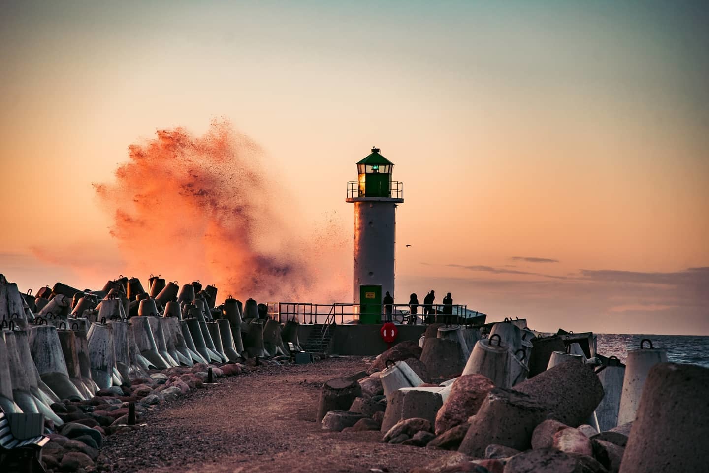
Foto: Monta Blāze
[ENG]
The pier of the port is one of the most important hydraulic structures - a dam that stretches from the mainland to the sea and protects the port from waves, ice and sediments.
The origins of Ventspils South Pier can be traced back to the 17th century, when it stretched for 250 meters, but closer to today - in 1905, according to the project of port engineer M. Šistovskis, the South Pier was extended to 1490 m. Šistovskis designed the ends of the piers as temporary structures, assuming that the length of the piers could increase in the future. During the First World War, the port and its hydraulic structures suffered greatly: everything that burns was burned down by the Russian army, the rest was blown up. The gradual renovation of the port and its buildings began after the establishment of the Republic of Latvia in 1918. In 1937, the South Pier was rebuilt to a length of 208 meters. The ambitious renovation and development of the Port of Ventspils continued during the planned years of the Soviet economy, as well as after the restoration of Latvia's independence. In the summer of 2018, the reconstruction works of the South Pier were carried out. For resistance to waves, the South Pier has been supplemented with 1,349 five-tonne tetrapods, 19 13-tonne tetrapods and 204 concrete blocks, each weighing 45 tonnes. The pier facades have also been repaired, the surface has been restored and new lighting has been built along the entire length of the pier. The last significant renovation work at the South Pier was carried out in the mid-1990s, but the South Pier had not undergone such a thorough reconstruction as in 2018 for at least 60 years.
Today, the South Pier, creating its entire length of promenade (about 900 meters), is used as a tourist attraction and is one of the most popular recreation areas in our city.
There have been several physical geocaches from different authors dedicated to the South Pier, but the environmental conditions (water, salt, ice, storms, etc.) make sure that the cache won't stay for too long — so I decided to create a virtual here!
To register the find, you must, as a minimum, add a unique photo of yourself (face isn't required), your nickname or GPS with the South beacon in the background. Bonus points if you've been creative with your photo - jumping, holding the beacon in your hands etc. :)
Logs that do not meet the criteria may be deleted without prior notice!
Virtual Rewards 3.0 - 2022-2023
This Virtual Cache is part of a limited release of Virtuals created between March 1, 2022 and March 1, 2023. Only 4,000 cache owners were given the opportunity to hide a Virtual Cache. Learn more about Virtual Rewards 3.0 on the Geocaching Blog.