Arena de hierro ⏳ magnetita en Lanzarote
Eisensand ⏳ Magnetit auf Lanzarote
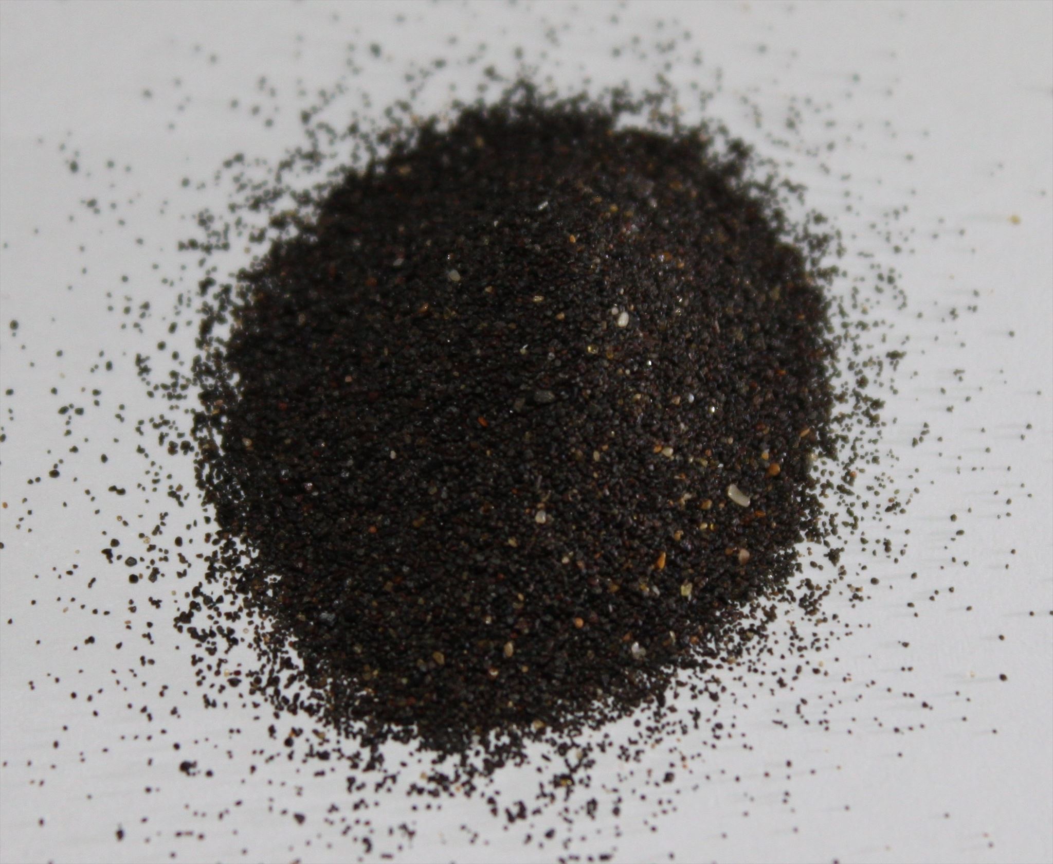
Iron sand ⏳ magnetite in Lanzarote
Durante mis vacaciones anteriores en Lanzarote, noté rayas oscuras en la arena mientras caminaba por la playa, lo que despertó mi interés. Durante una investigación posterior, me encontré con este fenómeno. Nació la idea de este escondite terrestre. Muchas gracias también a Team N51E06 que me envió apoyó la implementación de la idea.
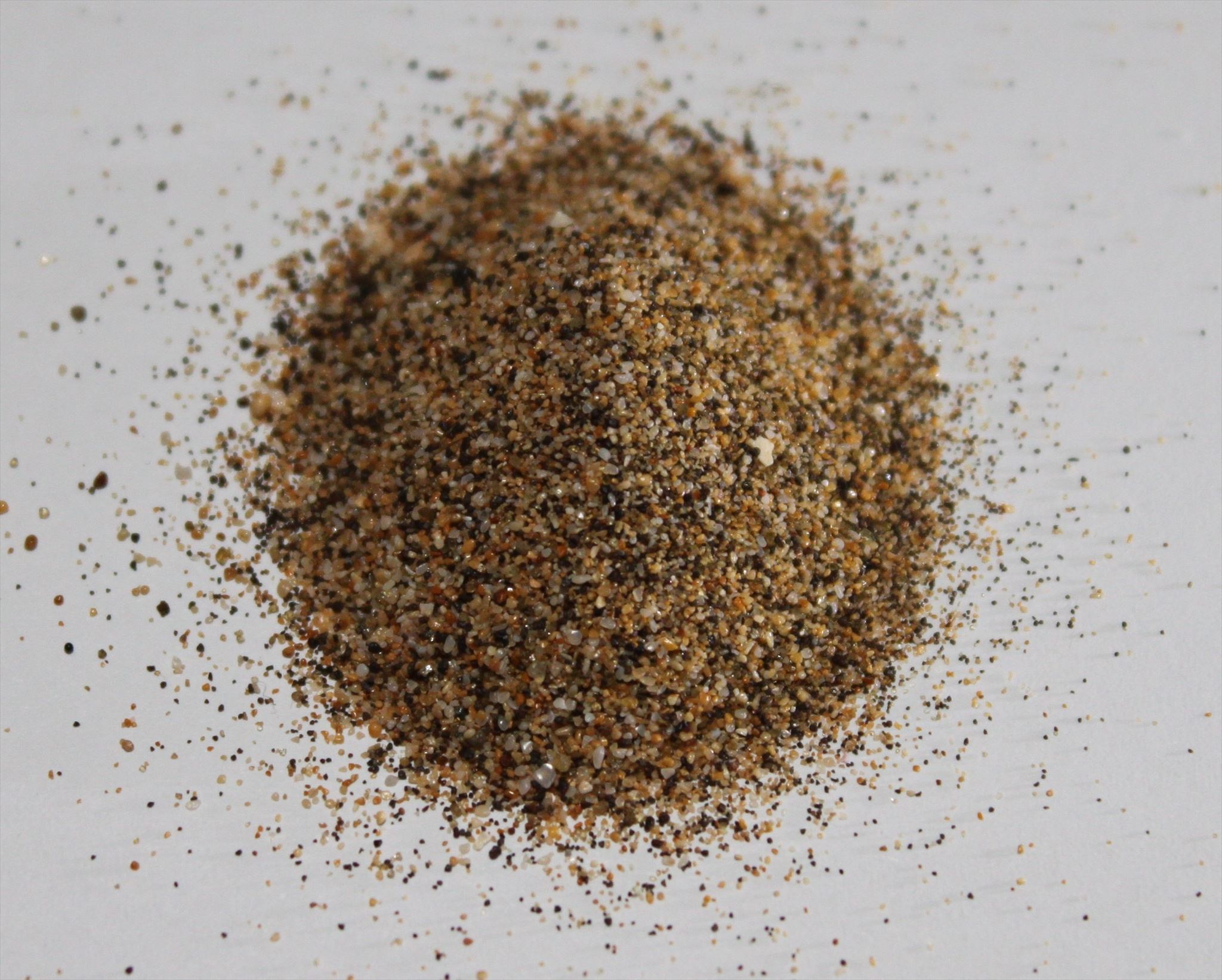
La arena de hierro es coloquialmente una arena enriquecida con minerales pesados que tiene una alta proporción de minerales de hierro. El color de la arena es gris oscuro o negruzco. El mineral de hierro predominante en la arena es la magnetita Fe3O4, por lo que el contenido de hierro puro puede estar entre el 54% y el 60% según la ubicación y la calidad. Además, también pueden estar presentes otros compuestos minerales, tales como. B. óxido de titanio (IV) TiO2, óxido de vanadio (III) V2O3, óxido de magnesio y otros.

Después del aluminio, el hierro es el metal más común en la corteza terrestre. Debido a la actividad volcánica, se puede transportar en cantidades relativamente grandes desde las áreas más profundas de la corteza o desde el manto superior a la superficie terrestre, donde se convierte en parte de la roca de lava en forma de minerales de hierro. Hace millones de años, se crearon áreas con roca ferrosa en diferentes partes del mundo y luego se erosionaron durante largos períodos de tiempo.
Fuente: https://de.wikipedia.org/wiki/Eisensand
Lanzarote es una isla de origen volcánico. Hace unos 36 millones de años, repetidas erupciones volcánicas submarinas comenzaron a formar la base de la isla. Hace 15,5 millones de años, Lanzarote creció sobre la superficie del mar.
La superficie de Lanzarote evidentemente ha estado formada por cuatro fases volcánicas principales:
-
Fase 1: Aquí se crearon el macizo de Famara en el norte, la segunda cordillera más alta Los Ajaches, la parte oriental de la llanura del Rubicón y volcanes individuales cerca de Tías en el sureste. Esta fase de erupción tuvo lugar hace 15,5 a 3,8 millones de años, interrumpida por tiempos marcados por la erosión.
-
Fase 2: Aquí emergen la parte occidental de la llanura del Rubicón con la Montaña Roja, algunos volcanes en el interior de la isla, así como la Montaña de Guanapay cerca de Teguise y la Atalaya cerca de Haría en el norte. Esta fase eruptiva tuvo lugar hace alrededor de 2,7 a 1,3 millones de años.
-
Fase 3: Aquí había hasta 100 centros de erupción, que se extendieron por toda la isla hace unos 730.000 a 240.000 años.
-
Fase 4: Aquí se hace una distinción: la primera fase de erupción provocó que el Malpaís de la Corona de 30 kilómetros cuadrados y por tanto la Cueva de los Verdes surgieran en el noreste de Lanzarote hace unos buenos 3.000 años. La segunda fase de erupción ocurrió de 1730 a 1736 y 1824, con más del 23 por ciento del área de Lanzarote cubierta con alrededor de tres a cinco kilómetros cúbicos de lava nueva de unos 30 nuevos cráteres volcánicos. En términos de duración, cantidad de lava erupcionada y composición de las lavas (incluido el basalto olivino), este orden de magnitud es uno de los más importantes del mundo después de las erupciones del Eldgjá (alrededor de 934) y el cráter Laki (1783-1784). ) en Islandia.
Fuente: https://de.wikipedia.org/wiki/Lanzarote
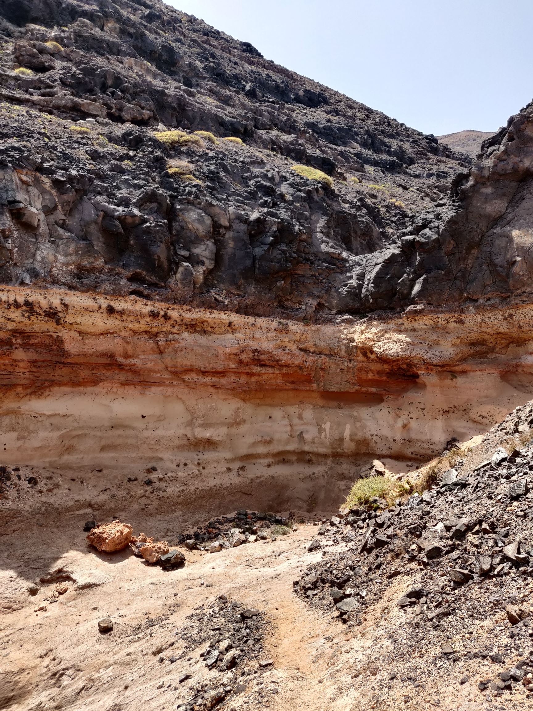 Se puede suponer que la primera piedra de las playas de arena del este de Lanzarote se colocó en la fase 1. En la fase 4, la capa de arenisca se cubrió con nueva lava cuando entró en erupción Monte Corona.
La arena de hierro se encuentra en casi todo el mundo. Sin embargo, rara vez se encuentra en cantidades económicamente significativas y degradables (por ejemplo, en Chile, Guatemala, Indonesia, Canadá, Japón y Nueva Zelanda). Las piedras o granos, pequeños pero pesados, se distribuían a lo largo de las costas por el viento, las olas y las mareas. Debido a su mayor peso específico (5,2 g/cm3) que la arena normal (cuarzo) (2,65 g/cm3), se concentraron.
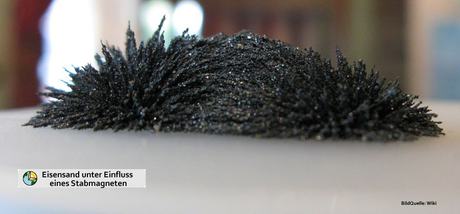
¿Puedes filtrar arena magnética?
Sí, de hecho es muy fácil. Todo lo que necesita es una hoja de papel, un imán y un recipiente pequeño. Sostenga la hoja de papel sobre un lugar con arena seca (!!) y acérquese lentamente con el imán. Ahora mueva la hoja hacia adelante y hacia atrás un poco sobre la arena. Luego sostienes la sábana sobre un recipiente y retiras el imán. El mineral ahora cae en el recipiente sin que quede ningún residuo en su imán.
Para registrar este caché de la tierra,
Ahora dirígete a "Playa de los Pocillos". Las coordenadas del listado están en el medio de la playa y son irrelevantes para responder las preguntas. En WP1 puede comenzar su paseo por la playa y caminar aproximadamente 1 km hasta WP2 sin mayores problemas. Es mejor hacer esto durante la marea baja justo antes de que la marea comience de nuevo. Todo lo que necesita para los experimentos es un imán, un trozo de papel y posiblemente una pequeña caja / bolsa de plástico para muestras posteriores en casa. Luego, aborde las tres tareas siguientes. No tiene que ser un geólogo para esto, su comprensión y observaciones en el sitio son completamente suficientes. La tarea tres se puede responder con un poco de trabajo doméstico sin demasiados problemas.
-
Busque manchas oscuras en el área donde las olas lavan suavemente la arena. Ahora filtre la arena como se describe arriba y observe la muestra. ¿Puedes ver diferentes colores?
-
Eche un vistazo más de cerca a la sección de playa. ¿Hay lugares donde se concentre la arena de hierro? Si es así, ¿cómo lo explicas?
-
Cuando llegue a casa, lleve una buena balanza de cocina digital y pese gran parte de la muestra que trajo (~ 20 gramos deberían ser suficientes; esto corresponde a 1-2 cucharadas soperas con arena; los números son tan significativos que la pequeña cantidad es suficiente para el experimento). ¡Ahora realice un "filtrado" como se describe arriba! Para lograr el resultado más preciso posible, debe repetir el filtrado 2-3 veces. Una vez que su filtrado ya no suministre minerales, puede pasar a la parte final de la tarea.
Ahora pese la arena filtrada restante ¿Cuál fue el porcentaje de magnetita en su muestra? ¡Agregue imágenes de su muestra, así como las partes filtradas al registro!

Photos: andi_ilvese
-
Tome una foto de usted mismo o de un artículo personal con la silueta de WP1 de fondo. De acuerdo con las pautas del 10 de junio de 2019, esta es una condición de registro aceptable (https://www.gc-reviewer.de/fotobeweis-bei-earthcaches-wieder-zugelassen/ y https://www.geosociety.org/GSA/Education_Careers/Field_Experiences/EarthCache/GSA/fieldexp/EarthCache/guidelines/home.aspx). Los registros en los que no se adjunta la foto se eliminarán sin comentarios después de un período de 14 días.
Por favor envíeme sus respuestas de las tareas por correo electrónico o centro de mensajes y luego podrá registrar el Earthcache inmediatamente. ¡No tienes que esperar a que me suelte el registro! Verificaré que las respuestas y soluciones enviadas sean correctas y me pondré en contacto contigo si es necesario.
Tenga en cuenta :
En 1993, Lanzarote fue la primera isla en ser declarada Reserva de la Biosfera por la UNESCO.
|
En España, los turistas deben tener cuidado por dónde van a recoger. En principio, está permitido si los particulares quieren llevarse arena y piedras de España. En Canarias, sin embargo, solo debes recolectar fuera de los parques nacionales. Los viajeros pueden llevarse la arena negra de Tenerife y la arena blanca de Mallorca. Si quieres llevarte piedras de Lanzarote, también es posible, siempre que no se trate de minerales del Parque Nacional de Timanfaya. Llevar arena y piedras de la playa: por lo que esto no suele ser un problema en España.
|
Fuente: https://www.bussgeld-info.de/sand-mithaben-verboten/

Bei meinem vergangenen Urlaub auf Lanzarote sind mir bei einem Strandspaziergang dunkle Streifen im Sand aufgefallen, die mein Interesse geweckt haben. Bei einer anschließenden Recherche stieß ich auf dieses Phänomen. Die Idee für diesen Earthcache war entstanden. Vielen Dank auch an Team N51E06, die mich bei der Umsetzung der Idee unterstützt haben.
Als Eisensand bezeichnet man umgangssprachlich einen mit Schwermineralien angereicherten Sand, der einen hohen Anteil an Eisenmineralien aufweist. Die Farbe des Sandes ist dunkelgrau oder schwärzlich. Das im Sand vorherrschende Eisenmineral ist Magnetit Fe3O4, wobei der reine Eisenanteil je nach Fundort und Qualität zwischen 54 % und 60 % liegen kann. Zusätzlich können auch noch andere Mineralverbindungen vorhanden sein, wie z. B. Titan(IV)-oxid TiO2, Vanadium(III)-oxid V2O3, Magnesiumoxid und weitere.
Eisen ist nach Aluminium das häufigste Metall in der Erdkruste. Durch vulkanische Aktivität kann es aus den tieferen Bereichen der Kruste oder aus dem oberen Mantel in relativ großen Mengen an die Erdoberfläche transportiert werden, wo es in Form von Eisenmineralen Bestandteil des Lavagesteins wird. An verschiedenen Stellen der Erde sind so vor vielen Millionen Jahren Gebiete mit eisenhaltigem Gestein entstanden, anschließend über lange Zeiträume erodiert.
Quelle: https://de.wikipedia.org/wiki/Eisensand
Lanzarote ist eine Insel vulkanischen Ursprungs. Vor rund 36 Millionen Jahren begannen wiederholte unterseeische Vulkanausbrüche den Sockel der Insel zu bilden. Vor 15,5 Millionen Jahren wuchs Lanzarote über die Meeresoberfläche hinaus.
Die Oberfläche Lanzarotes ist nachweislich durch vier vulkanische Hauptphasen entstanden:
-
Phase 1: Hier entstanden das Famara-Gebirgsmassiv im Norden, der zweithöchste Gebirgszug Los Ajaches, der östliche Teil der Rubicón-Ebene sowie einzelne Vulkane bei Tías im Südosten. Diese Eruptionsphase fand vor 15,5 bis 3,8 Millionen Jahren statt, unterbrochen durch Zeiten, die von Erosion geprägt waren.
-
Phase 2: Hier entstanden der westliche Teil der Rubicón-Ebene mit dem Montaña Roja, einige Vulkane im Inselinneren, sowie der Montaña de Guanapay bei Teguise und der Atalaya bei Haría im Norden. Diese eruptive Phase fand vor etwa vor 2,7 bis 1,3 Millionen Jahren statt.
-
Phase 3: Hier gab es bis zu 100 Eruptionszentren, die sich vor etwa 730.000 bis 240.000 Jahren über die ganze Insel verteilt haben.
-
Phase 4: Hier wird unterschieden: Die erste Eruptionsphase ließ vor gut 3.000 Jahren im Nordosten Lanzarotes das 30 Quadratkilometer große Malpaís de la Corona und damit auch die Cueva de los Verdes entstehen. Die zweite Eruptionsphase ereignete sich von 1730 bis 1736 und 1824, wobei über 23 Prozent der Fläche Lanzarotes mit etwa drei bis fünf Kubikkilometer neuer Lava aus etwa 30 neuen Vulkankratern bedeckt wurden. Diese Größenordnung ist hinsichtlich Dauer, eruptierter Lavamengen und Zusammensetzung der Laven (unter anderem Olivin-Basalt) in historischer Zeit weltweit eine der bedeutendsten nach den Eruptionen der Eldgjá (um 934) und der Laki-Krater (1783–84) in Island.
Quelle: https://de.wikipedia.org/wiki/Lanzarote
Man kann davon ausgehen, dass der Grundstein für die östlichen Sandstrände Lanzarotes in der Phase 1 gelegt wurde. In der Phase 4 wurde die Sandsteinschicht dann beim Ausbruch des Monte Corona von neuer Lava überlagert.
Eisensand kommt fast überall auf der Welt vor. Doch wirtschaftlich bedeutsame und abbaubare Mengen findet man ihn jedoch nur selten (z.B. in Chile, Guatemala, Indonesien, Kanada, Japan und Neuseeland). Die kleinen aber schweren Steine oder Körner wurden durch Wind, Wellen und Gezeiten an den Küsten verteilt. Auf Grund ihres größeren spezifischen Gewichtes (5,2 g/cm3), als des normalen (Quarz-)Sandes (2,65 g/cm3), lagerten sie sich konzentriert ab.
Kann man magnetischen Sand filtern?
Ja, sogar sehr einfach. Du benötigst dafür nur ein Blatt Papier, einen Magneten und ein kleines Gefäß. Halte das Blatt Papier über eine Stelle mit trockenem (!!) Sand und nähere Dich langsam mit dem Magneten. Jetzt bewegst Du das Blatt ein wenig über dem Sand hin und her. Danach hältst Du das Blatt über ein Gefäß und entfernst den Magneten. Das Mineral fällt nun in das Gefäß, ohne dass Reste an Deinem Magneten verbleiben.
Um diesen Earthcache zu loggen,
begib Dich nun zum „Playa de los Pocillos“. Die Listingkoordinaten liegen mitten auf dem Strand und sind für die Beantwortung der Fragen unerheblich. Bei WP1 kannst Du Deinen Strandspaziergang starten und ohne größere Probleme ca. 1 km bis zum WP2 spazieren. Am Besten machst Du dies bei Ebbe kurz bevor die Flut wieder einsetzt. Für die Experimente benötigst Du lediglich einen Magneten, ein Stück Papier und evtl. ein kleines Döschen/eine kleine Plastiktüte für spätere Proben zuhause. Befasse Dich dann mit den unten stehenden drei Aufgaben. Du musst hierfür kein Geologe sein – Deine Auffassungsgabe und Beobachtungen vor Ort sind völlig ausreichend. Aufgabe drei kann mit ein wenig Hausarbeit ohne große Probleme beantwortet werden.
-
Suche nach dunklen Stellen in dem Bereich, wo die Wellen sanft den Sand umspülen. Führe nun wie oben beschrieben eine Filterung des Sandes durch und betrachte die Probe. Kannst Du unterschiedliche Farben erkennen?
-
Betrachte Dir den Strandabschnitt etwas genauer. Gibt es Stellen, wo der Eisensand konzentriert vorhanden ist? Wenn ja, wie erklärst Du Dir das?
-
Zuhause angekommen nimm eine gute digitale Küchenwaage und wiege eine Menge Deiner mitgebrachten Probe ab (~20 Gramm sollten ausreichen; das entspricht 1-2 Suppenlöffel mit Sand; die Zahlen sind so signifikant, dass für den Versuch die kleine Menge ausreicht). Führe nun eine „Filterung“ wie oben beschrieben durch! Um ein möglichst genaues Ergebnis zu erzielen, solltest Du die Filterung 2-3 mal wiederholen. Sobald Deine Filterung kein Mineral mehr liefert, kannst Du zum letzten Teil der Aufgabe gehen.
Wiege nun den verbliebenen gefilterten Sand ab.Wie hoch war der Prozentsatz an Magnetit in Deiner Probe? Füge bitte dem Log Bilder Deiner Probe sowie den gefilterten Teilen bei!
Photos: andi_ilvese
-
Mache ein Foto von Dir oder einem persönlichen Gegenstand mit der Silhouette bei WP1 im Hintergrund. Gemäß Guidelines vom 10. Juni 2019 ist diese eine akzeptable Logbedingung (https://www.gc-reviewer.de/fotobeweis-bei-earthcaches-wieder-zugelassen/ und https://www.geosociety.org/GSA/Education_Careers/Field_Experiences/EarthCache/GSA/fieldexp/EarthCache/guidelines/home.aspx). Logs bei denen das Foto nicht angehängt ist, werden nach einer Frist von 14 Tagen kommentarlos gelöscht.
Deine Antworten zu den Aufgaben schicke mir bitte per Mail oder Message-Center und danach darfst Du den Earthcache sofort loggen. Du musst auf keine Logfreigabe von meiner Seite warten! Ich werde die zugesandten Antworten und Lösungen auf ihre Richtigkeit prüfen und mich ggf. bei Dir melden.
Bitte beachtet unbedingt :
Als erste Insel wurde Lanzarote 1993 vollständig von der UNESCO zum Biosphärenreservat erklärt.
|
In Spanien sollten Touristen darauf achten, wo sie sammeln gehen. Grundsätzlich ist es gestattet, wenn Privatpersonen Sand und Steine aus Spanien mitnehmen wollen. Auf den Kanaren sollte jedoch nur außerhalb der Nationalparks gesammelt werden. Reisende dürfen dann den schwarzen Sand aus Teneriffa ebenso mitnehmen wie den weißen von Mallorca. Wollen sie von Lanzarote Steine mitnehmen, ist das ebenfalls möglich, wenn es sich nicht um Mineralien aus dem Timanfaya-Nationalpark handelt. Sand und Steine vom Strand mitnehmen: In Spanien ist das also üblicherweise kein Problem.
|
Quelle: https://www.bussgeld-info.de/sand-mitnehmen-verboten/

During my previous vacation on Lanzarote, I noticed dark streaks in the sand while walking on the beach, which piqued my interest. During a subsequent research, I came across this phenomenon. The idea for this earth cache was born. Many thanks also to Team N51E06 who have supported the implementation of the idea.
Iron sand is colloquially a sand enriched with heavy minerals that has a high proportion of iron minerals. The color of the sand is dark gray or blackish. The predominant iron mineral in the sand is magnetite Fe3O4, whereby the pure iron content can be between 54% and 60% depending on the location and quality. In addition, other mineral compounds can also be present, such as. B. titanium (IV) oxide TiO2, vanadium (III) oxide V2O3, magnesium oxide and others.
After aluminum, iron is the most common metal in the earth's crust. Due to volcanic activity, it can be transported in relatively large quantities from the deeper areas of the crust or from the upper mantle to the earth's surface, where it becomes part of the lava rock in the form of iron minerals. Millions of years ago, areas with ferrous rock were created in different parts of the world and then eroded over long periods of time.
Source: https://de.wikipedia.org/wiki/Eisensand
Lanzarote is an island of volcanic origin. Around 36 million years ago, repeated undersea volcanic eruptions began to form the island's base. 15.5 million years ago Lanzarote grew above the sea surface.
The surface of Lanzarote has evidently been formed by four main volcanic phases:
-
Phase 1: The Famara massif in the north, the second highest mountain range Los Ajaches, the eastern part of the Rubicón plain and individual volcanoes near Tías in the southeast were created here. This eruption phase took place 15.5 to 3.8 million years ago, interrupted by times that were marked by erosion.
-
Phase 2: Here the western part of the Rubicón plain with the Montaña Roja, some volcanoes in the interior of the island, as well as the Montaña de Guanapay near Teguise and the Atalaya near Haría in the north emerged. This eruptive phase took place around 2.7 to 1.3 million years ago.
-
Phase 3: There were up to 100 eruption centers here, which were spread over the entire island about 730,000 to 240,000 years ago.
-
Phase 4: A distinction is made here: The first eruption phase caused the 30 square kilometer Malpaís de la Corona and thus also the Cueva de los Verdes to arise in the northeast of Lanzarote a good 3,000 years ago. The second eruption phase occurred from 1730 to 1736 and 1824, with over 23 percent of the area of Lanzarote being covered with about three to five cubic kilometers of new lava from about 30 new volcanic craters. In terms of duration, erupted lava quantities and composition of the lavas (including olivine basalt), this order of magnitude is one of the most important in the world after the eruptions of the Eldgjá (around 934) and the Laki craters (1783–84) in Iceland.
Source: https://de.wikipedia.org/wiki/Lanzarote
It can be assumed that the foundation stone for the eastern sandy beaches of Lanzarote was laid in phase 1. In phase 4, the sandstone layer was covered by new lava when Monte Corona erupted.
Iron sand occurs almost everywhere in the world. However, it is only rarely found in economically significant and degradable quantities (e.g. in Chile, Guatemala, Indonesia, Canada, Japan and New Zealand). The small but heavy stones or grains were distributed along the coasts by wind, waves and tides. Due to their higher specific weight (5,2 g/cm3) than normal (quartz) sand (2,65 g/cm3), they were concentrated.
Can you filter magnetic sand?
Yes, even very simple. All you need is a sheet of paper, a magnet and a small vessel. Hold the sheet of paper over a spot with dry (!!) sand and slowly approach it with the magnet. Now move the leaf back and forth a little over the sand. Then you hold the sheet over a vessel and remove the magnet. The mineral now falls into the vessel without any residue remaining on your magnet.
To log this earth cache,
Now go to "Playa de los Pocillos". The listing coordinates are in the middle of the beach and are irrelevant for answering the questions. At WP1 you can start your walk on the beach and walk about 1 km to WP2 without any major problems. It is best to do this at low tide just before the tide starts again. All you need for the experiments is a magnet, a piece of paper and possibly a small box / plastic bag for later samples at home. Then deal with the three tasks below. You don't have to be a geologist for this - your comprehension and observations on site are completely sufficient. Task three can be answered with a little housework without too much trouble.
-
Look for dark spots in the area where the waves gently wash the sand. Now filter the sand as described above and look at the sample. Can you see different colors?
-
Take a closer look at the beach section. Are there places where the iron sand is concentrated? If so, how do you explain it to yourself?
-
When you arrive at home, take a good digital kitchen scale and weigh a lot of the sample you brought with you (~ 20 grams should be enough; this corresponds to 1-2 soup spoons with sand; the numbers are so significant that the small amount is sufficient for the experiment). Now carry out a "filtering" as described above! In order to achieve the most accurate result possible, you should repeat the filtering 2-3 times. Once your filtering is no longer supplying mineral, you can move on to the last part of the task.
Now weigh the remaining filtered sand. What was the percentage of magnetite in your sample? Please add pictures of your sample as well as the filtered parts to the log!

Photos: andi_ilvese
-
Take a photo of yourself or a personal item with the silhouette at WP1 in the background. According to the guidelines of June 10, 2019, this is an acceptable log condition (https://www.gc-reviewer.de/fotobeweis-bei-earthcaches-wieder-zugelassen/ and https://www.geosociety.org/GSA/Education_Careers/Field_Experiences/EarthCache/GSA/fieldexp/EarthCache/guidelines/home.aspx). Logs in which the photo is not attached will be deleted without comment after a period of 14 days.
Please send me your answers from the tasks by email or message center and then you can log the Earthcache immediately. You don't have to wait for a log release from my side! I will check the sent answers and solutions for their correctness and get in touch with you if necessary.
Please note :
In 1993, Lanzarote was the first island to be fully declared a Biosphere Reserve by UNESCO.
|
In Spain, tourists should be careful where they go to collect. In principle, it is permitted if private individuals want to take sand and stones from Spain with them. In the Canaries, however, you should only collect outside the national parks. Travelers can then take the black sand from Tenerife as well as the white sand from Mallorca with them. If you want to take stones with you from Lanzarote, this is also possible, provided that it is not minerals from the Timanfaya National Park. Bringing sand and stones with you from the beach: So this is usually not a problem in Spain.
|
Source: https://www.bussgeld-info.de/sand-mitnehmen-verboten/