Inleiding route
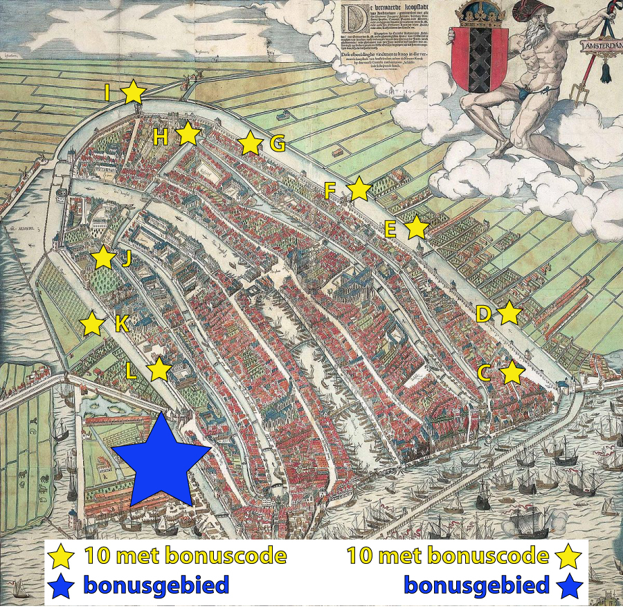
Langs de locatie waar in de 15e eeuw de stadsmuur van Amsterdam stond, ligt een in 2020 geplaatste serie van 10 caches + 1 bonuscache. Wanneer je op Amsterdam Centraal aankomt, is dit een mooie wandelroute langs de oude begrenzing van de middeleeuwse stad (langs het Singel en de Kloveniersburgwal), die tevens nummer 5 in de Canon van Amsterdam is. Vergeet niet de reference points te bezoeken, dat maakt de route nou juist zo leuk!
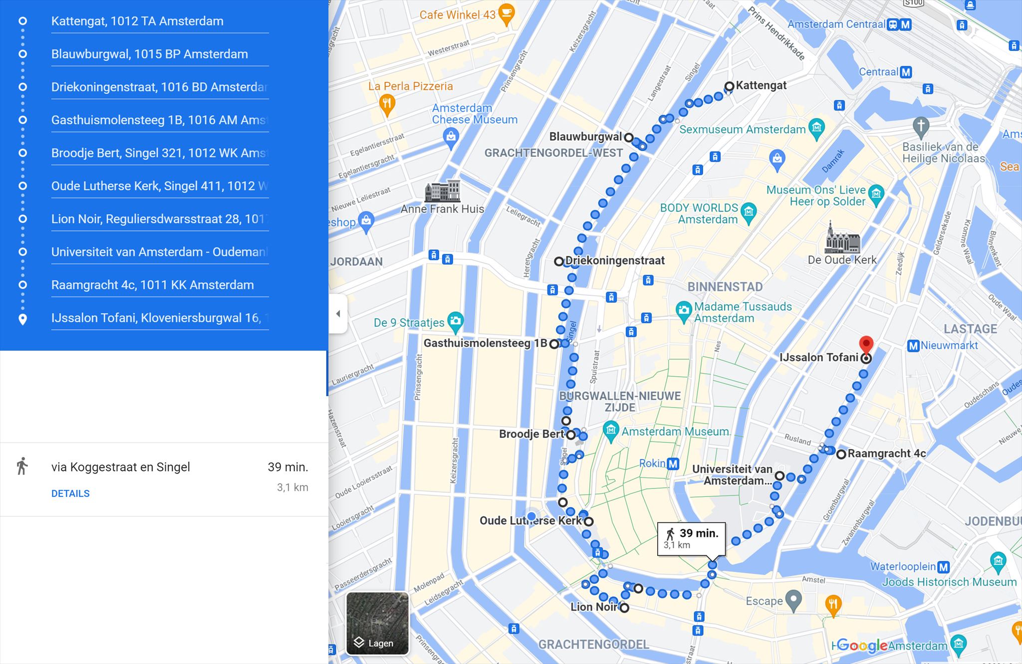
Vergeet niet de bonusletters te noteren die op de logrollen van deze cache-serie (C t/m L) vermeld staan voor de BONUSCACHE. De BONUS CACHE bevindt zich ergens in de buurt van cache L en is te vinden door het invullen van de formule van de BONUSCACHE die je kunt vinden op de geocache-kaart. Op de oude kaart van Amsterdam hierboven zie je de locaties van de caches C t/m L van deze serie. Onderstaand de meest optimale looproute op de kaart: exclusief zoektocht naar bonuscache is de route 3 km lang.
Cachelocatie
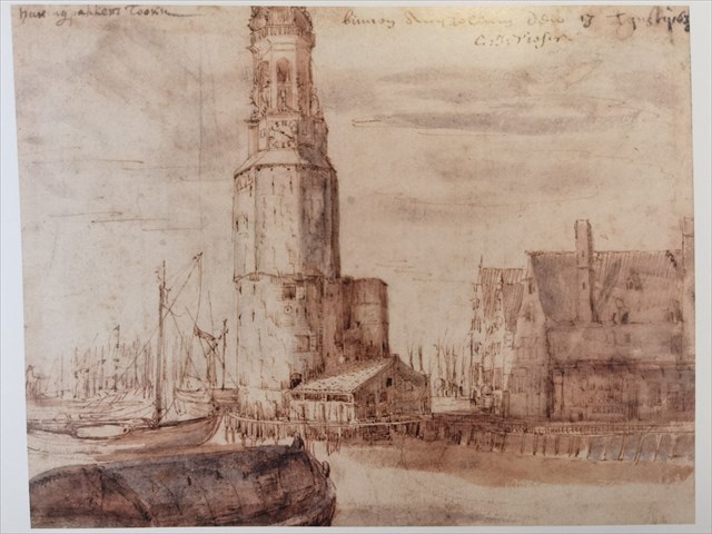
De cachelocatie is pal naast de fameuze Koepelkerk. Na de sloop van de Koepelkerk aan de Stadhouderskade heeft de Ronde Lutherse Kerk die naam overgenomen, al is het gebouw niet meer in gebruik als kerk. Na een renovatie na een brand in 1993 is de koepel hersteld en wordt deze van binnen blauw aangelicht. Bron: Wikipedia Koepelkerk
Waypoints directe omgeving:
Ter hoogte van het terras van Singel 2 kun je vanaf de overzijde van het water in de kademuur een afwijkend type steen ontwaren. Het betreft hier overblijfselen van de 15e eeuwse stadsmuur. Ook heb je vanaf die plek (Singel 20) een riant uitzicht op de Ronde Lutherse Kerk, het 'pantheon' van Amsterdam. Bron: informatiebord tegenover Singel 16
Aan de Herenmarkt staat het West-Indisch Huis, dat in 1617 werd gebouwd als vleeshal en wachtruimte voor de schutterij. In het voormalige hoofdkwartier van de West-Indische Compagnie (WIC) gaven de bevelhebbers van de WIC in 1625 opdracht tot de bouw van een fort op het eiland Manhattan, de eerste aanzet tot wat de wereldstad New York zou worden. Bron: Wikipedia West-Indisch Huis
Along the location of the former old city wall of the 15th century is a series of caches placed in 2020. When you arrive at Amsterdam Central, this is a nice walking route along the old borders of the medieval city (along Singel and Kloveniersburgwal). Don't forget to visit the reference points with their explanation. This makes this route extra nice.
The old city wall is gone, but from the address Singel 20 you can see the stones are a remnant of the ancient citywall of the 15th century in the quay wall on the other side of the water. Right of this one sees the 'pantheon' of Amsterdam: a round church.
Don't forget to write down the bonus letters that are listed on the log rolls of the caches named C to L. The BONUS CACHE is somewhere near cache L and can be found when filling in the code of the BONUS CACHE which you can find on the geocache-map. On the first map above you can see the locations of the caches C to L of this series. On the second map you see the optimal walking route on the map: excluding searching the bonus cache, the route is 3 km long.