Raunis
Pierakstiet slēpņu logbukos atrodamos kodus A - I. Tie būs vajadzīgi bonusa slēpņa atrašanai.
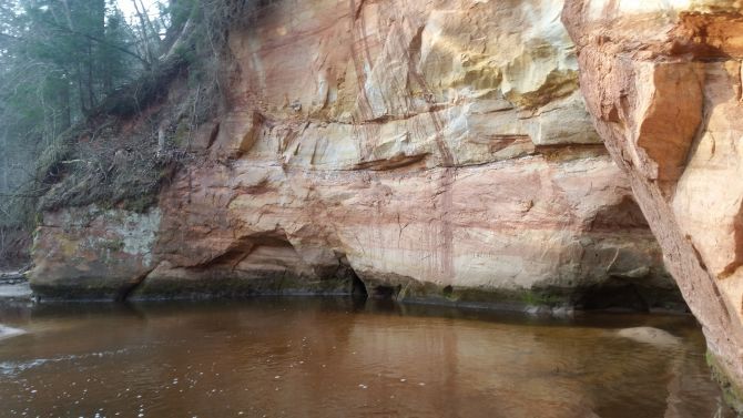
Raunis ir viena no retajām Latvijas upēm, kuras vārds ir vīriešu dzimtē. Upe ir 22 km gara, ārkārtīgi ainaviska un strauja. Rauņa kritums uz 1 kilometru ir vidēji 7,7 m. Upe ir līkumaina un sekla – dziļums no 50 cm līdz 1 m. Gultne ir ļoti akmeņaina, īpaši lejas posmā. Rauņa lejtecē smilšakmens atsegumi sasniedz pat 30 metru augstumu. Apskatāms arī Rauņa Skaņaiskalns (kalns ar atbalsi), kur atrastas senu dzīvnieku fosilijas. Upes ieleja ir grūti pieejama, un cilvēku ietekme uz to ir bijusi ļoti niecīga.
Sīkāk: Rauņa lejteces ieži un Rauņa slāņi
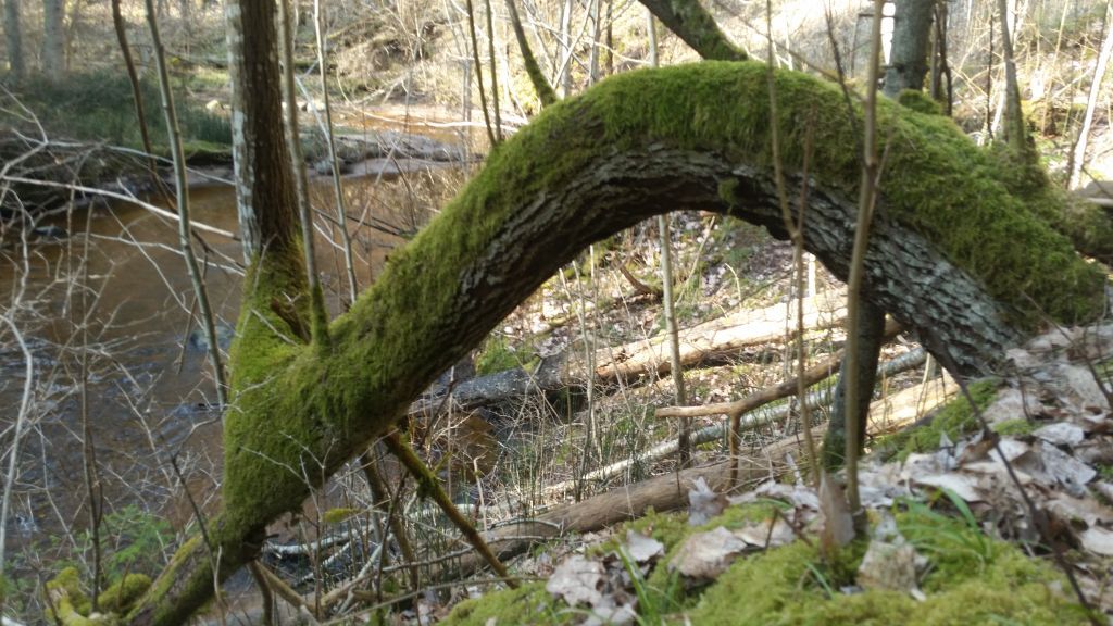
Sarežģītības pakāpe: vidēji sarežģīta. Pārgājiens ietver upes šķērsošanu pa akmeņiem, kritušiem kokiem, jāpārvar stāvi kāpumi un aizas, bezceļš. Pārgājiena segums: upes gultne un pati upe, mežā iemītas dzīvnieku taciņas, bezceļš. Liela iespējamība saslapināt kājas un sasmērēt drēbes.
Var mēģināt iet, kāpjot stāvajos 15 - 30 m augstajos stāvkrastos vai izvēloties tos apiet, šķērsojot upi. Otrajā variantā būs iespēja apskatīt klinšu atsegumus pilnā to krāšņumā. Iesaku paņemt līdzi apavus upes brišanai, jo gultne ir akmeņaina. Vairākas reizes upe jāšķērso pa pārkritušiem un upes sanestiem kokiem, akmeņiem vai ari pārbrienot.
Slēpņi ir izvietoti netālu no upes, daži ir arī krastu augšpusē. Tie ir melnas PET sagataves vai koka mulāžas, kas veiksmīgi integrētas meža vidē. Izvietoti pie kokiem un celmiem ne augstāk par 2 m. Nekur nav jākāpj kokos, taču līdz tiem ir jātiek. Tāpēc Terrain norādīts kopā ar nokļūšanu līdz tiem no ceļa.
Tajos ir viesu grāmata un zīmulis, bet drošības labad paņemiet līdzi savu, jo tie mēdz pazust, nolūst. BYOP
Koordinātes var būt neprecīzas, kā jau mežā, tāpēc lasiet hintu vai skatiet spoilerbildes. Lūdzu slēpni nolieciet atpakaļ atbilstoši spoilerbildei un hintam.
Šis slēpnis ir daļa no slēpņu sērijas „RAUNIS TRAIL”, kas izvietota gar Rauņa un Raunas upes krastiem. Maršrutu var iedalīt 3 posmos:
1) No Vidzemes šosejas A2 1.5 km pirms Bērzkroga līdz P30 ceļam starp Priekuļiem un Bērzkrogu - 7 km.
2) No P30 ceļa līdz P28 ceļam, kas ved no Priekuļiem uz Raunu - netālu no Vaives dzirnavām -9 km
3) No P28 ceļa līdz ceļam P20, kas ved no Cēsīm uz Valmieru, - 11 km. Šajā posmā maršruts turpinās gar Raunu.
4) Bonusa slēpnim arī vajadzētu vismaz vienu stundu.
Tā kā apvidus ir sarežģīts, iešanas vidējais ātrums ir 2 km/h. Plānojiet laiku tā, lai nebūtu jāiet pa tumsu! Iesaku trailu sadalīt divās daļās - to veikt divās dienās. Otrajā dienā vēl jāpaņem bonusa slēpnis. Lai to atrastu, pierakstiet slēpņos atrodamos kodus A - I.
UZMANĪBU! Starp 29. un 30. slēpni ir dzelzceļa tilts (augstākais Baltijā - 24 m) pār Raunu.Tā ir slēgta apsargājama teritorija. To nevar šķērsot gar upi !!!
ENG
Raunis
Raunis is one of the few rivers in Latvia, whose name is male. The river is 22 km long, quite scenic and fast. River’s water sea level decline per 1 kilometer is on average 7.7 meters. The river is curvy and shallow - depth from 50 cm to 1 m. The riverbed is very rocky, especially in the lower part of the trail. In the lower reaches of Raunis, sandstone outcrops reach a height of up to 30 meters. You can also see Raunis Skaņaiskalns (a hill with an echo), where fossils of ancient animals have been found. The river valley is difficult to access and has had very little human impact.
More information: www.daba.gov.lv/public/lat/ia ... www.daba.gov.lv/public/lat/ia ...
Level of complexity: moderately difficult. The hike includes crossing the river over rocks, fallen trees, you’ll need to overcome steep hills and gorges. The is a high probability of getting your feet wet and getting your clothes dirty by crossing the river.
You can try to go by climbing the steep 15-30m high cliffs or choosing to bypass them by crossing the river. In the latter, it will be possible to see the rock outcrops in their full glory. I recommend to bring another pair of shoes to cross the river with, because the riverbed is rocky.
Caches are located near the river, some are also at the top of the banks. These are black PET bottle preforms or wooden fakes that have been successfully integrated into the forest environment. Placed near trees and stumps not higher than 2m above ground. You don't have to climb trees anywhere, but you have to get the location. That's why the terrain difficulty is set as such.
Caches have a guest book and a pencil, but bring your own pencil just in case.
The coordinates may be inaccurate, as the caches are in a forest, so read the hint or look at the spoiler picture for answers.
This cache is part of the cache series „RAUNIS TRAIL”, located along the banks of the Raunis and Rauna rivers. The route can be divided into 3 stages:
1) From Vidzeme highway A2 1.5 km before Bērzkrogs to P30 road between Priekuļi and Bērzkrogs - 7 km.
2) From the P30 road to the P28 road leading from Priekuli to Rauna - near Vaives dzirnavas (Vaives mill) -9 km
3) From the P28 road to the P20 road leading from Cēsis to Valmiera - 11 km. At this stage, the route continues along Rauna.
4) The bonus cache should also take 1-2 hours.
Due to the complexity of the terrain, the average walking speed is 2 km/h. Plan your time so you don't have to go through the dark! I recommend dividing the trail into two parts - do it in two days. On the second day you have to pick up https: //coord.info/GC8P03T. To find it, write down the codes A - I located in other caches.