|
Sills
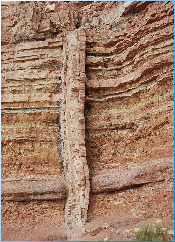
In geology, a sill is a tabular sheet intrusion that has intruded between older layers of sedimentary rock, beds of volcanic lava or tuff, or even along the direction of foliation in metamorphic rock. The term sill is synonymous with concordant intrusive sheet. This means that the sill does not cut across preexisting rocks, in contrast to dikes, discordant intrusive sheets which do cut across older rocks. Sills are fed by dikes, except in unusual locations where they form in nearly vertical beds attached directly to a magma source. The rocks must be brittle and fracture to create the planes along which the magma intrudes the parent rock bodies, whether this occurs along preexisting planes between sedimentary or volcanic beds or weakened planes related to foliation in metamorphic rock. These planes or weakened areas allow the intrusion of a thin sheet-like body of magma paralleling the existing bedding planes, concordant fracture zone, or foliations.
Sills parallel beds (layers) and foliations in the surrounding country rock. They can be originally emplaced in a horizontal orientation, although tectonic processes may cause subsequent rotation of horizontal sills into near vertical orientations. Sills can be confused with solidified lava flows; however, there are several differences between them. Intruded sills will show partial melting and incorporation of the surrounding country rock. On both contact surfaces of the country rock into which the sill has intruded, evidence of heating will be observed (contact metamorphism). Lava flows will show this evidence only on the lower side of the flow. In addition, lava flows will typically show evidence of vesicles (bubbles) where gases escaped into the atmosphere. Because sills generally form at shallow depths (up to many kilometers) below the surface, the pressure of overlying rock prevents this from happening much, if at all. Lava flows will also typically show evidence of weathering on their upper surface, whereas sills, if still covered by country rock, typically do not.
אופניים מג'מטיים
עפרון פולש הוא גוף מוגלתי עם יחס רוחב-גובה גבוה מאוד, כלומר עוביו בדרך כלל קטן בהרבה משני הממדים האחרים. עובי יכול להשתנות מסולם סנטימטר למטר רבים, והממדים הרוחביים יכולים להשתרע על פני קילומטרים רבים. חולית זריעה היא חדירה לפתיחה חוצה חתכים, ומכניסה לצדדים שכבות או גופות אחרות של סלע; זה מרמז כי הסוללה תמיד צעירה יותר מהסלעים המכילים אותה. אופניים בדרך כלל הם בעלי זווית גבוהה עד כמעט אנכית באוריינטציה, אך עיוות טקטוני שלאחר מכן עשוי לסובב את רצף השכבות שדרכן מתפשטת הסוללה כך שהסוללה הופכת לאופקית. פריצות כמעט אופקיות, או תואמות, לאורך מטוסי מצעים בין שכבות נקראות אדניות פולשניות.
לעיתים מופיעים דיקיות בנחילים, המורכבים מכמה עד מאות שקעים שהוצבו פחות או יותר בזמן בעת אירוע פולשני יחיד. נחיל הסוללה הגדול בעולם הוא נחיל הסוללה מקנזי בשטחי צפון-מערב, קנדה. [2]
אופניים נוצרים לרוב כנחלים רדיאליים או קונצנטריים סביב פולשנים פלוטוניים, צווארים געשיים או פתחי מזינה בקונוסים געשיים. האחרונים ידועים כמצלצולים.
חולי הזכוכית יכולים להשתנות במרקם וההרכב שלהם יכול לנוע בין דיבאז 'או בזלתית לגרניטית או ריאוליטית, אך מבחינה עולמית הרכב הבזלתי שורר, ובא לידי ביטוי עולה בכמויות אדירות של תוספות הנגזרות על ידי המעטפת דרך ליטוספרה שבורה לאורך כל תולדות כדור הארץ. צוקי פגמטיטים כוללים סלעי גרניט גבישיים גסים במיוחד - הקשורים לעיתים קרובות לחדירות גרניט בשלב מאוחר או להפרדות מטמורפיות. צוקים אפלטיים הם פולשנים עדינים או בעלי מרקם מסוכר של קומפוזיציה גרניטית.
Associated Ore Deposits
Certain layered intrusions are a variety of sill that often contain important ore deposits. Precambrian examples include the Bushveld, Insizwa and the Great Dyke complexes of southern Africa, the Duluth intrusive complex of the Superior District, and the Stillwater igneous complex of the United States. Phanerozoic examples are usually smaller and include the Rùm peridotite complex of Scotland and the Skaergaard igneous complex of east Greenland. These intrusions often contain concentrations of gold, platinum, chromium and other rare elements.
פיקדונות עפרות משויכים
חדירות שכבות מסוימות הן מגוון אדן המכילים לעתים קרובות מרבצי עפרות חשובים. דוגמאות קודמות למכלול כוללות את מתחם הבושד, אינסיזווה ומתחמי הדיק הגדול של דרום אפריקה, מתחם הדולוט הפולשני של מחוז סופיריור, ואת המתחם הצפוני של סטילווטר של ארצות הברית. דוגמאות פרנוזאוזיות בדרך כלל קטנות יותר וכוללות את מתחם ה- Peridotite Rùm של סקוטלנד ואת מתחם ה- Skaergaard האגומי של מזרח גרינלנד. פריצות אלה מכילות לרוב ריכוזי זהב, פלטינה, כרום ואלמנטים נדירים אחרים.
Transgressive Sills
Despite their concordant nature, many large sills change stratigraphic level within the intruded sequence, with each concordant part of the intrusion linked by relatively short dike-like segments. Such sills are known as transgressive, examples include the Whin Sill and sills within the Karoo basin. The geometry of large sill complexes in sedimentary basins has become clearer with the availability of 3D seismic reflection data. Such data has shown that many sills have an overall saucer shape and that many others are at least in part transgressive.
אדני עבר
למרות אופיים המסכים, אדמות גדולות רבות משנות את הרמה הסטרטיגרפית ברצף הפולש, כאשר כל חלק קונקורדנטי של הפריצה מקושר בין קטעים דמויי סלים קצרים יחסית. אדמות כאלה ידועות כמעבריות, דוגמאות כוללות את אדן הכננת ואדמות בתוך אגן קארו. הגיאומטריה של מתחמי אדן גדולים באגני משקע התבהרה עם זמינותם של נתוני השתקפות סייסמיים תלת-ממדיים. נתונים כאלה הראו כי אדמות רבות הן בעלות צורת צלוחית כוללת ושרבים אחרים לפחות עוברים באופן חלקי.
Access
Visiting the Ramon Crater can vary from a stop off on a journey through the Negev to witness the crater from above, or a longer visit to take in the history and science of the area, hike, drive or cycle through the makhtesh, and appreciate the unique geology that is on offer.
The visitors center, located on the edge of Makhtesh Ramon in the city of Mitspe Ramon is the gateway to the makhtesh. As visitors ascend the ramp through the building, they view displays that present ‘windows’ on to the geography, geology, flora, fauna and history of the region from prehistoric to modern times. The display leads upward to a breathtaking view of the makhtesh through a floor-to-ceiling window and the rooftop. A film explains how the makhtesh was formed and a three-dimensional interactive model helps bring home an understanding of the topography of this unique region. The visitors center personnel are able to provide information on trails and conditions within the makhtesh.
גישה
ביקור במכתש רמון יכול להשתנות מתחנה למסע בנגב כדי לחזות במכתש מלמעלה, או ביקור ארוך יותר בכדי לבחון את ההיסטוריה והמדע של האזור, לטייל, לנסוע או לרכוב במכתש ולהעריך את גאולוגיה ייחודית המוצעת.
מרכז המבקרים, השוכן בקצה מכתש רמון בעיר מצפה רמון, הוא שער הכניסה למכתש. כאשר המבקרים עולים על הרמפה דרך הבניין, הם רואים תצוגות המציגות 'חלונות' אל הגיאוגרפיה, הגיאולוגיה, החי, החי וההיסטוריה של האזור מהפרהיסטוריה ועד ימינו. התצוגה מובילה כלפי מעלה לתצפית עוצרת נשימה על המכתש דרך חלון מהרצפה עד התקרה והגג. סרט מסביר כיצד נוצר המכתש ודגם אינטראקטיבי תלת מימדי עוזר להביא הבנה הביתה של הטופוגרפיה של אזור ייחודי זה. אנשי מרכז המבקרים מסוגלים לספק מידע על שבילים ותנאים בתוך המכתש.
|