DEUTSCH
Landesvermessung
Der Kontrollpunkt ist Teil eines landesweiten Netzes von Lagefixpunkten. Diese bilden die Grundlage für das Koordinatensystem der Schweiz. Sämtliche Raumdaten und Positionsbestimmungen beziehen sich auf dieses Koordinatensystem, so auch die amtliche Vermessung. Diese dokumentiert laufend das Grundeigentum, indem sie Grundstücksgrenzen definiert sowie Gebäude, Gewässer oder Waldränder erfasst und nachführt. Mit dem Schutz des Grundeigentums leistet sie einen wichtigen Beitrag zu Rechtssicherheit und Wohlstand in unserem Land.
Kontrollpunkt Landesmuseum
Beim Kontrollpunkt kannst Du die Genauigkeit Deines Smartphones oder Navigationsgerätes überprüfen. Als Geocacher wissen wir selbstverständlich, wie wir uns die aktuellen Koordinaten anzeigen lassen können. Alternativ kann vor Ort aber auch der dort angebrachte QR-Code eingelesen werden; die daraufhin angezeigte Webpage des Kantons zeigt dann die gemessenen Koordinaten (sogar in beiden Koordinatensystemen) und die Abweichung an.
Geschichte dieses Steins
Dieser Granitstein mit der Bezeichnung 4e markierte von 1971 bis 1986 die Landesgrenze zu Deutschland zwischen den Gemeinden Wasterkingen und Hohentengen am Hochrhein. Durch den grenzüberschreitenden Kiesabbau und die nachfolgende Begradigung der Landesgrenze wurde der Grenzstein nicht mehr benötigt und findet nun inmitten der Stadt Zürich erneut Verwendung.
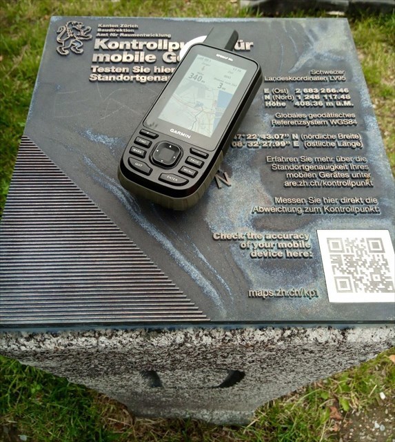
Koordinaten des Kontrollpunktes
Schweizer Landeskoordinaten LV95:
E (Ost): 2’683’256.46
N (Nord): 1’248’117.47
Höhe: 408.36 m ü. M.
Globales geodätisches Referenzsystem WGS 84:
N 47° 22.717 E 8° 32.466
Quelle: Flyer 'Amt für Raumentwicklung'
Logbedingungen
Füge Deinem Log bitte diese zwei Bilder hinzu:
- Ein Foto Deines GPS-Geräts (oder eines persönlichen Gegenstands) auf dem Granitstein
- Ein Foto (oder Screenshot) mit den klar lesbaren Koordinaten auf Deinem GPS-Gerät/Mobiltelefon
Selbstverständlich können diese zwei Fotos auch in einem Bild kombiniert werden.
Liebe App Benutzer
Ihr müsst die Bilder NICHT an meinen Account schicken, sondern mit Eurem Log hochladen. Wer damit Mühe hat, kann das gerne auch zu Hause in aller Ruhe im Web nachholen. Das gilt auch für Apps "bei denen man nur 1 Bild hochladen kann". Dann fügt Ihr das zweite Bild später via Web Eurem bestehenden Log hinzu. |
ENGLISH
National coordinate system
The control point is part of a nationwide network of fixed points which form the basis of Switzerland’s coordinate system. All spatial data and determinations of location refer to this system of coordinates – including the official cadastral surveys done on an ongoing basis to document land ownership by defining property boundaries and recording and tracking buildings, bodies of water and woodland boundaries. These surveys help safeguard property ownership and thus play an important role in assuring legal certainty and prosperity in this country.
National Museum control point
You can use the control point to check the accuracy of your smartphone or navigation device. Scan the QR code and you'll then see the amount by which your device deviates from the control point, which is defined to the precise centimetre.
The history of this stone
From 1971 to 1986 this piece of granite, designated 4e, marked the national border with Germany between the municipalities of Wasterkingen and Hohentengen am Hochrhein. Cross-border gravel quarrying and the subsequent straightening of the border meant that the boundary stone was no longer needed. Now it's back in use in the heart of the City of Zurich.
Coordinates of the control point
Swiss LV95 coordinate system:
E (East): 2’683’256.46
N (North): 1’248’117.47
Elevation: 408.36 meters above sea level
World Geodetic System (WGS 84):
N 47° 22.717 E 8° 32.466
Source: Flyer 'Amt für Raumentwicklung'
Logging Requirements
Please add the following two images to your log:
- A photo of your GPS device (or a personal item) on the granite stone
- A photo (or a screenshot) with the clearly visible coordinates on your GPS device/mobile phone
Of course, you may combine these two pictures in one single image.
Dear App User
Please DO NOT send these images to my account, just upload it with you log. If your App doesn't allow uploading more than one picture, just upload the second one later using the website. |
Virtual Rewards 2.0 - 2019/2020
This Virtual Cache is part of a limited release of Virtuals created between June 4, 2019 and June 4, 2020. Only 4,000 cache owners were given the opportunity to hide a Virtual Cache. Learn more about Virtual Rewards 2.0 on the Geocaching Blog.