Der Cache:
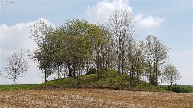
An der Hangkante fällt eine kleine Erhebung auf, die einen quadratischen Betonsockel mit einem Metalldeckel trägt. Manchmal ist unter dem Deckel ein leises Gluckern zu hören. Wir stehen hier auf einem mit Erdreich bedeckten Wasserbehälter, der zur Zuverlässigkeit der Trinkwasserversorgung der Gemeinde Obertaufkirchen und des Isentals beiträgt. Ganz nebenbei hat man einen schönen Blick auf das Dorf.
Obertaufkirchner Wasserversorgung
Die Cacherunde ist ca. 4 km lang und zu Fuß in gut zwei Stunden zu bewältigen. Mit einem feldwegtauglichen Fahrrad geht es schneller. Auch geländegängige Kinderwagen können mitgenommen werden. Alle Caches sind so versteckt, dass sie nah an Wegen liegen. Nirgendwo muss geklettert oder an gefährlichen Stellen gesucht werden. Daher die dringende Bitte: Bleibt auf den Wegen! Trampelpfade querfeldein schädigen die Bauern und können dazu führen, dass unser schönes Hobby reglementiert wird. Die meisten Cache-Dosen können auch von Kindern erreicht werden, bei einigen ist die Hilfe von Größeren nötig.
Einzelne Caches sind mit Kraftfahrzeugen erreichbar. Darauf wird mit den Attributen hingewiesen. Wo kein "Parken"-Attribut steht, kann man mit KFZ nicht hinfahren (zumindest nicht, ohne Aufsehen zu erregen, was wir Cacher ja nicht wollen).
The Cache:
At the edge of the slope a small elevation draws our attention, which carries a square concrete base with a metal cover. Sometimes you can hear a soft lapping under the lid. We stand here on a soil-covered water tank, which contributes to the reliability of the drinking water supply of the communities Obertaufkirchen and those in and near the valley of the Isen. As a side effect, you have a nice view of the village.
The cache circuit is approximately 4 kilometres long and can be done in two to two and a half hours by pedestrians. You also can use a bike or take along an all-terrain stroller. All caches are hidden closse to paths. It is not necessary to climb or to search at dangerous places. Therefore the urgent request: Please stay on the roads and paths! Cross country trails damage the fields and annoy the farmers. They can lead to legal reglementations of geocaching.
Some caches can be reached by motorised vehicles. This is referred to with a "Parking" attribute. Where you don't find this attribute you can't reach the cache by car or any other motorised vehicle (at least not without attracting attention).