ESTRATIFICAÇÃO DA
“COSTA DO OURO”


PORTUGUÊS
Estratigrafia

“A estratigrafia é a ciência do ramo da geologia que estuda e descreve os estratos. Classicamente define-se como a descrição de todos os corpos rochosos que formam a crosta terrestre e estabelece relações entre a sua distribuição no espaço com a sua sucessão no tempo para interpretar a sua história geológica.
A estratigrafia não está relacionada apenas com a posição ou sucessão original das camadas rochosas, assim como não se limita às relações de idade das mesmas. Esta ciência trata também das relações de forma, arranjo interno, distribuição geográfica, composição litológica, conteúdo fossilífero, propriedades geoquímicas e geofísicas, entre outras características e propriedades das camadas de rochas, e ainda com a sua interpretação genética, ambiental e a sua história geológica.
O objetivo fundamental da estratigrafia é através da observação das unidades litológicas e das suas propriedades chegar ao seu modo de origem estabelecendo a sua evolução temporal e espacial. Fundamentalmente a estratigrafia estuda as relações no espaço e no tempo dos conjuntos líticos e dos acontecimentos neles registados, de modo a chegar à reconstituição da história na Terra.
Ao falarmos em estratigrafia devemos ter sempre presente a definição de estrato, assim, define-se como estrato ou camada os conjuntos diferenciados de corpos líticos com características que os distinguem de outros que os precedem ou sucedem.
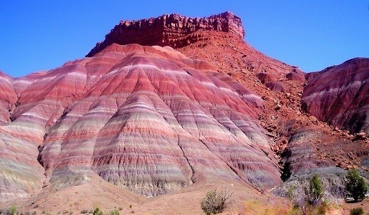
A separação de camadas vizinhas pode ser feita por planos bem marcados ou mudanças graduais de qualquer uma das suas propriedades. As camadas podem ter espessuras variáveis, desde estratos inferiores a um centímetro até camadas com vários metros de espessura.
Não ocorrendo falhas ou dobras na rocha, a camada mais antiga é a camada mais abaixo, sendo que a mais recente se encontra mais acima. Assim introduzimos um dos seis princípios fundamentais da estratigrafia, oprincípio da sobreposição de estratos – Em condições normais, toda a camada sobreposta a outra é mais moderna que ela, este axioma recorre a critérios de polaridade como marcas de raízes, icnofósseis, granotriagem, figuras sedimentares, analise microtectónica, entre outras”.
FILÕES MAGMÁTICOS

Os filões são corpos magmáticos, de forma tabular, resultantes do preenchimento de fraturas existentes nas rochas. A sua atitude e dimensões são variáveis, podendo apresentar espessuras que variam entre poucos milímetros (filonetes) a alguns metros ou mesmo quilómetros e extensões desde alguns metros até quilómetros. A sua espessura nem sempre é constante e por vezes ramificam-se. Observam-se, frequentemente, variações texturais e mineralógicas num mesmo filão. Existem vários tipos de filões.

PERGUNTAS:

Para “encontrar/registar” esta cache deverá: provar que esteve no local e responder às seguintes questões, enviando um email/mensagem de Geocaching, com as respostas, em português ou em inglês, para o perfil deste Clube.
Só depois, de enviar as respostas, e conforme as “guidelines” para as Earthcaches, deverá efectuar o seu registo!
Serão removidos todos os registos que não obedeçam a estes requisitos.
Com base nas tuas observações efectuadas na visita a este local e com base nas suas investigações, procura responder às seguintes questões:
1- Qual é o objectivo fundamental da estratigrafia?
No WP1/Stage1:
2 - Quais as cores que consegue observar nos estratos do afloramento?
3 - Na parede da falésia onde se observam estratos, quantas camadas existem desde o
nível do calhau até ao topo?
4 - Qual o grau de inclinação dos estratos?
No local da earthcache, existe uma abertura na falésia!
5 - À direita da entrada deste “túnel” existe um fenómeno geológico! Identifica-o!
6 - Qual o tipo de rocha existente nesta zona?
7 – Estamos na presença de um tubo lávico? Uma gruta?
8 - Estima o comprimento do túnel
9 - Quais são as cores dentro?
Também e apesar de ser opcional, convidamos a que tire e partilhe no seu registo uma foto sua com o GPS na entrada da “gruta”.

“COSTA DO OURO”
STRATIFICATION


ENGLISH

STRATIFICATION

"Stratigraphy is the science of the branch of geology that studies and describes the strata. Classically it is defined as the description of all the rocky bodies that form the earth's crust and establishes relations between its distribution in space with its succession in time to interpret its geological history.
Stratigraphy is not only related to the original position or succession of the rock layers, but is not limited to their age relationships. This science also deals with relations of form, internal arrangement, geographic distribution, lithologic composition, fossiliferous content, geochemical and geophysical properties, among other characteristics and properties of rock layers, as well as their genetic and environmental interpretation and their geological history .
The fundamental objective of the stratigraphy is through the observation of the lithological units and their properties to reach their mode of origin establishing their temporal and spatial evolution. Fundamentally the stratigraphy studies the relations in space and time of the lithic assemblages and the events registered therein, in order to arrive to the reconstitution of the history in the Earth.
When we speak of stratigraphy, we must always keep in mind the definition of stratum, so we define stratum or layer as differentiated sets of lithic bodies with characteristics that distinguish them from others that precede or succeed them. The separation of neighboring layers can be done by well-marked planes or gradual changes of any of their properties. The layers can vary in thickness from layers less than one centimeter to layers of several meters thick.
If there are no faults or folds in the rock, the oldest layer is the lower layer, the latter layer being higher up. Thus we introduce one of the six fundamental principles of stratigraphy, the principle of overlapping strata - under normal conditions, the entire layer superimposed on another is more modern than it, this axiom uses criteria of polarity as marks of roots, icnofósseis, granotriagem, figures sedimentary, microtectonic analysis, among others ".

MAGMATIC REEFS
The reefs are magmatic bodies, in tabular form, resulting from the filling of existing fractures in the rocks. Their attitude and dimensions are variable, being able to present thicknesses that range from a few millimeters (phylons) to a few meters or even kilometers and extensions from a few meters to kilometers. Its thickness is not always constant and sometimes branching. Textural and mineralogical variations are often observed in the same vein. There are several types of seams.

QUESTIONS:
To "find / register" this cache should: prove that you were on the spot and respond to the following questions by sending an email / Geocaching message, with the answers, in Portuguese or English, to the profile of this Club.
Only then, to send the answers, and according to the guidelines for Earthcaches, you must register!
All records that do not meet these requirements will be removed.
On the basis of your observations made on the visit to this site and on the basis of your investigations, please answer the following questions:
1- What is the fundamental objective of stratigraphy?
In WP1 / Stage1:
2 - What colors can you see in the strata of the outcrop?
3 - On the cliff wall where strata are observed, how many layers exist from the
level of the pebble to the top?
4 - What is the degree of inclination of the strata?
At the site of the earthcache, there is an opening on the cliff!
5 - To the right of the entrance of this "tunnel" there is a geological phenomenon!
Identify it!
6 - What kind of rock exists in this area?
7 - Are we in the presence of a lava tube? A grotto?
8 - Estimate the length of the tunnel
9 - What are the colors inside?
Also, although it is optional, we invite you to take and share a photo of yourself with the GPS at the entrance of the cave.
