The geology of Dartmoor is a complex one, involving a wide range of different distinct geological units and rock types. Despite this variation, Dartmoor's geology is most commonly associated with granite. This is because the highest part of Dartmoor is almost exclusively composed of granite, and it the reason that this outcrop is prominent above the surround area. The properties of granite have resulted in the interesting geomorphological features that are commonly seen across much of the upland part of Dartmoor National Park. However, arguably the more dramatic and geologically interesting part of the geology of Dartmoor can be found circling this granite outcrop. This change in bedrock, from the relatively hard granite to softer units, is most clearly shown on the western and northern boundaries of the national park. Here the land sharply slopes away from the higher areas to the surrounding countryside.
Granite is formed from felsic magma, which is rich in silica. When this magma cools, it forms rock rich in feldspar and quartz. The size of these crystals, which are visible to the naked eye, is due to the magma cooling down, and solidifying, before reaching the surface. This process of cooling results in relatively slow cooling, allowing large crystals to form. Normally the resulting granite is upwards of 80% feldspar and quartz. These feldspar crystals and quartz make up the white, or see through, component of the granite and are easily identifiable. Another common component, and easily identifiable, is mica or biotite mica. This is the darker material, almost black, between the lighter crystal. A common feature, that is found across much of the Dartmoor granite, including the tors, are phenocrysts. These are defined as being conspicuous crystals distinctly larger than the surrounding components of rock. If you have spent any length of time walking on Dartmoor, you will be very familiar with granite as it makes up the vast majority of the loose rock on the ground, the tors and many of the buildings.
On a smaller scale the change of geological units can affect the topography, and landscape features, that can be seen. The location of this EarthCache, on the River Lyd overlooking Great Nodden, highlights how the local geology has changed the shape of the valley here to be very geomorpholigically interesting.
The model for how valleys are formed by riverine processes is a very simple one. However, as with most things the more variables you introduce the more complex this becomes. At its most basic a river valley is formed by the downwards erosion caused by the water, and materials it carries. As the river erodes down, a steep gorge is created. Depending on the geology this can end up being very deep and vertically sided. Lydford Gorge further downstream is a great example of this. Eventually the sides of this channel or gorge becomes unstable and collapses, creating a slope either side of the river. This creates the start of the valley and over time this will deepen and widen, shown in Figure 1.
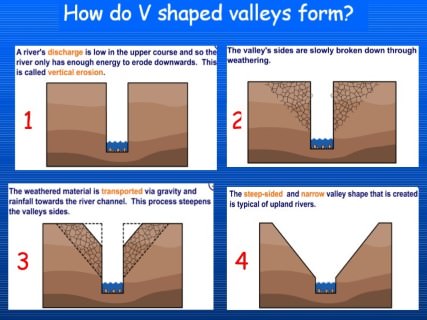 Figure 1) The stages leading to the classic erosion of a V shaped river valley
As mentioned above when variables, such as different geologies or even multiple geological units are introduced, the shape of the valley formed will be altered. As such, when you look at a valley, the shape can help indicate certain aspects of the geology of the area. A good example of this, and that can be seen here, is an asymmetric valley, where the steepness of the slopes on either side of the river are not the same. Although most valleys are, to an extent, asymmetric, many display degrees of symmetry, that without taking measurements makes them appear symmetrical.
The reason for the formation of an asymmetric valley can be caused by different factors and, in some cases, a combination of factors. These factors are the processes of erosion and deposition, variations within a geological unit, boundaries between different geological units and prevailing weather.
Erosion/Deposition
One of the more commonly associated riverine process, frequently highlighted in geography at school and EarthCaches within this hobby, focus on the power of erosion and deposition of a river. A river will erode, through various means, the channel that it is in. Similarly rivers can deposit material that they are carrying, leading to the creation of 'new land'. In a situation where one bank or valley slope, is being eroded and at the same time the other bank or valley slope is having material deposited against it, the river will appear to slowly move in the direction of that erosion. Eventually this will leave the river channel to one side of the centre of the valley, creating an asymmetry. Figure 2 shows this process in a verity of scenarios.
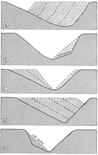 Figure 2) Various scenarios showing the change of a valleys symmetry by erosion and deposition
Variation in Geology
The underlying geology of a river channel is one of the largest factor in determining the shape, size and stability of a river channel. Even when there is a single geological unit within a section of river channel, changes in composition, relative resistance to erosion, as well as other naturally occurring variations, can result in one side of the river channel being more susceptible to erosion. Similarly where there are two geological units, the differences between these units will again impact the relative resistance to erosion of the rock. On the edge of Dartmoor the latter of these is evident and is particularly prone to causing asymmetric valleys because of the way that the geological units are lying. Because of the way that the Cornubian Batholith, the granite outcrop that makes up the higher parts of Dartmoor, has formed and been left exposed, the layers of rock are in just the right position to create asymmetric valleys. As the granite was formed and pushed up, the overlying rock was either titled, or partially 'destroyed' by the process. That means that the base of the overlying rocks sit at an angle. Over time these relatively weaker rocks were eroded from the main outcrop we see today. That means that in certain places around the outside of this granite extrusion you have higher points of this overlying rock sat on the general slope of the granite. If a river channel were to form at this point of contact then the river would erode the softer overlying material faster than the granite, causing the river channel to migrate down the slope of the granite extrusion, resulting in an asymmetric valley. Figure 3 shows this process.
 Figure 3) The simplified stage of the formation of an asymmetric valley based on different geological units
Prevailing Wind
The final factor that can cause asymmetric valleys is prevailing wind and weather. This can cause a number of different scenarios that affect the erosion of a river valley. The prevailing wind can cause the deposition of airborne sediment, such as Loess. This is known as aeolian deposition. Similarly to the riverine deposition, if the aeolian deposition are only present on one side of the valley then this will cause the build up of 'new land' on that side, affecting the appearance of the valley. As well as this the aspect of the valley slope can cause differences in plant life, causing variation in the stability of the valley slope. Where these differ significantly, most commonly found in very harsh environments such as mountainous areas or towards the poles, this can be enough to change the rate of erosion. Figure 4 shows this. A good indication of these process is the presence of widespread, very fine particles, on one bank only, or the marked difference in plants seen on either valley slope.
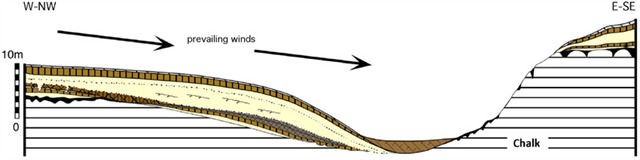 Figure 4) The process of aeolian deposition in creating an asymmetric valley
To log this EarthCache please go to the posted coordinates and send me your answers to these questions either through the messenger service or email.
Stand on the vantage point of the Rattlebrook Railway and look roughly north-east along the valley created by the River Lyd.
1) Look at the north west and south east slopes of the valley, particularly that formed by Great Nodden. Are they roughly the same steepest, and if not which side is steeper?
2) Find an area of exposed bedrock (there should be plenty along the side of the railway but you may have to wander up and down it) and study it. The area to the east of the River Lyd is granite bedrock. Are you currently stood on the same geology, or is the ridge you are stood on created by a different rock type?
3) Based on your answers to the first two questions how do you think the valley was formed, and out of the three main factors listed above which do you think has caused the shape of the valley?
4) Following on from your answer to number three, over time what do you think would happen to the course of the River Lyd here? (e.g. erode straight down, move further east or move further west)