Grótta Tombolo
The learning point of this earthcache is to get to know the tombolo formation better.
(After I came over this theme a while back in time I got inspired and since then been looking for a nice sample to make a earthcache of. Other nice examples: GC2EWFK, GC5V3ZB and GC7GN46)
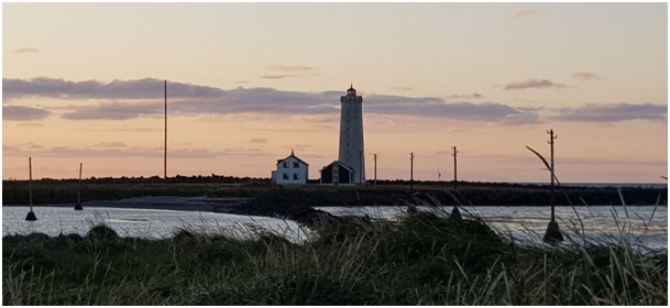
The coordinates lead you to the view of Grótta Island lighthouse, a beautiful view to the eye.
The island is out in the sea, but connected to the mainland by the tombolo that has been made by the wave sedimentation mechanism. A nice sandbank that is hidden/shown by the tide during the day that runs by. By studying the wave direction at the location you will better understand the text under where the whole phenomenon has been explained in detail.
Click the link below to find the tied forecast.
A tombolo is a coastal formation. It appears to be a small island that has not fully separated from the mainland. This island-like landform is actually attached to the coast by a thin sand bar or spit. Tombolos are sometimes referred to as “tied islands”, because it seems to tethered to the coast. These formation can be either solitary or found in clusters. When clustered, the sand bars may form a lagoon-like enclosure near the coast. These types of lagoons are likely to fill with sediment over time.
The formation of a Tombolo
Long shore Drift

Long shore drift occurs as waves push sediment (like sand, silt, and clay) towards the coastline at an angle. Instead of landing on the beach, this sediment begins to build up between the beach and an island, creating the bar mentioned above and effectively “tying” the island to the mainland. This drift is often influenced by the wind direction. When created by longshore drift, these formation are sometimes not considered a true tombolo.
Wave Diffraction and Refraction


A true tombolo is formed by wave diffraction and refraction. Waves move toward the coastline and are slowed down as they enter the shallower water. They first reach the islands that are close to the shore. Because these waves are moving at a slower than normal pace, they move around the island instead of over it. As the water moves more slowly around the island, it picks up sediment along the way. When the waves meet on the other side of the island (the side facing the coast), the sediment is deposited. This sediment continues to build up until it creates the sandbar that connects the island to the beach.
Changing Tombolos

Because of the unique shape of tombolos, they tend to be more likely to change over time due to weathering and tides than the regular coastline. Sometimes, the island at the end of the bar, or spit, is large enough that it supports commercial or residential activity. In order to prevent changes to the tombolo, the bar is reinforced with cement roads or parking lots. This prevents wind and waves from washing away the finer sediment on top of the bar.
To log this cache.
To get to log this cache you will have to visit and answer the questions which are related to the coordinates given the earthcache.
When answers are collected, send them to CO for verification.
You can log immediately after answers are sent CO. If there are any questions about your answers CO will contact you.
Logs without answers to CO or with pending questions from CO will be deleted without any further notice.
Please do not include pictures in your log that may answer the questions.
Questions
1. Answer the questions under by visiting the coordinates.
A. 1.) What is the typical size of the sediments that you can find in the area around the given coordinates that is affected by the wave diffraction and refraction? 2.) How would you describe the transition from the tombolo formation and further on to the mainland.
B. 1.) Will the size of the island affect the size and the way the tombolo has been formed? 2.) At the coordinates look down towards the shore line. While facing towards the open water, tell me which direction the long shore drift is moving the beach sand.
C. How wide is the tombolo on its smalles and biggest part?
2. (It’s voluntary to post a photo in your online log of your visit)
Without revealing any answers!