Gruta de Benagil
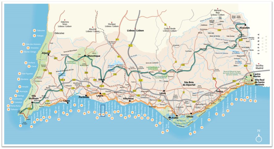
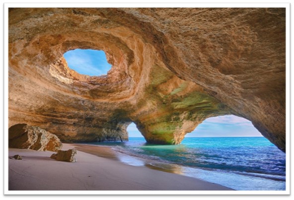
A gruta de Benagil situa-se junto da vila e praia com o mesmo nome, na zona costeira do concelho de Lagoa, no Algarve. Desde o ano de 2016, que esta gruta é considerada a mais bonita do mundo pelo “AnOther”, uma revista britânica de cultura, moda e lazer. Esta revista, descreve a zona costeira de Benagil, como a “casa de grutas, pequenas baías e praias escondidas”, que oferecem uma paisagem de rara beleza natural. É ainda considerado um dos cinco locais mais bonitos do mundo pelo “Huffpost”, um jornal digital americano, e que deve constar no topo de cada “bucket list”.
“Algumas das grutas são completamente escuras e estão subsubmersas, enquanto outras são muito pequenas, sendo impossível entrar. Mas a mais famosa é gigante, arejada e iluminada por uma palete de cores diversas que vêm do céu, do oceano, do sol e das rochas” (AnOther).
Localmente, a gruta de Benagil é conhecida também como “Furna de Benagil”, “Algar de Benagil”, ou “Algar do Rodeiro”.
A gruta de Benagil é uma cavidade natural formada pela erosão, com cerca de 20 milhões de anos. Se geologicamente é assim considerado, popularmente existe uma lenda associada à mesma sobre Carvoeiro e Benagil. Neste local encontravam-se dois apaixonados mouros: Ela (princesa), tinha o nome de Benagil, e ele (plebeu) chamava-se Carvoeiro. Um dia, o pai de Benagil, apercebendo-se do amor proibido que a sua filha tinha pelo rapaz que não era da condição que ele imaginara, perseguiu-a, e foi encontrá-la abraçada ao seu amado no sítio do costume. Carvoeiro foi morto, e o desgosto de Benagil foi de tal tamanho que todas as lágrimas que caíram formaram covas tão grandes que de elas se podia ver o mar.
E – The Benagil cave is located next to the village and beach with the same name, in the coastal area of the municipality of Lagoa, in Algarve. Since 2016, this cave is considered the most beautiful in the world by “AnOther”, a british magazine of culture, fashion and leisure. This magazine describes the coastal area of Benagil as the “home to a series of intricate caves, sea stacks and hidden beaches”, that it offers a landscape of rare natural beauty. It is still considered one of the five most beautiful places in the world by “Huffpost”, a digital american newspaper, and this place should be on top in each “bucket list”.
“Some of the caves are almost completely dark and submerged, while others are too small to squeeze inside. But the most famous is huge, airy and lit by an ever-changing palette of colours that come from the sky, the ocean, the sun and the rocks” (AnOther).
Locally, the Benagil cave is also known as the “Furna de Benagil” (Benagil blowhole), “Algar de Benagil” (Benagil pit cave/shaft cave/vertical cave), or “Algar do Rodeiro” (Ribeiro pit cave/shaft cave/vertical cave).
The Benagil cave is a natural cavity formed by erosion, about 20 million years old. If geologically it is so considered, popularly there is a legend associated with it about Carvoeiro and Benagil. In this place there were two passionate moors: She (princess), had the name of Benagil, and he (plebeian) had the name of Carvoeiro. One day, Benagil’s father realizing the forbidden love that his daughter had for the boy who wasn’t of the condition he had imagined, pursued her, and found her hugged with her beloved in the usual place. Carvoeiro was killed, and Benagil’s disgust was so great that all the tears that fell formed such large pits that one could see the sea from them.
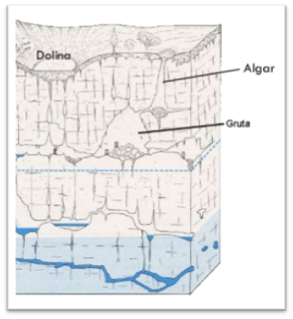
Algar
O termo algar provém do árabe “al-gar”, que significa “al-ĝār” – “caverna” ou “cova”.
Um algar é uma cavidade com desenvolvimento predominantemente vertical formada ao longo do tempo pela ação de agentes erosivos sobre rochas sedimentares. As rochas sedimentares formam-se sob baixas temperaturas e baixas pressões na superfície terrestre devido à deposição pela ação da água, vento ou gelo. As rochas sedimentares são constituídas por sedimentos, que são fragmentos de outras rochas ou fósseis. Frequentemente, os sedimentos são cristais únicos, que foram desgastados e partidos. A deposição destes sedimentos ao longo do tempo e posterior consolidação (por compactação, desidratação ou sedimentação) dão origem à rocha sedimentar. As rochas sedimentares são classificadas em clásticas, mecânicas ou detríticas (essencialmente compostas por fragmentos de outras rochas pré-existentes, como sílica, feldspato, entre outros), biogénicas (formadas por materiais gerados por organismos vivos, como corais, moluscos e foraminíferos), e quimiogénicas (formadas essencialmente por minerais precipitados quer por processos de precipitação quer por evaporação, como o calcário, o halite e o gesso).
A intempérie, a erosão, a transportação e a deposição são os elementos chave para o ciclo sedimentar.
A erosão é o principal fator da génese dos algares, em que ocorre a dissolução da rocha solúvel (predominantemente rocha calcária), por ação da água da chuva a partir da superfície, ou a partir de uma ação ascendente. A erosão consiste num processo de remoção de material sólido, que frequentemente foi lesionado pela intempérie, sendo que existem quatro agentes principais para a remoção dos sedimentos: ação da água, vento e gelo, como referidos anteriormente, mas também a gravidade.
De acordo com o processo de formação do algar, este pode ser classificado como: algar de dissolução (tem a forma de um poço, e resulta da infiltração da água da chuva através das fendas da rocha, dissolvendo-a e alargando as suas fendas), ou algar de abatimento (tem a forma de um sino, e resulta do desabamento de grutas por ação da gravidade, muitas vezes associado ao desgaste da rocha por uma força ascendente, como as ondas do mar).
Nas paredes da gruta é passível de se observar a estratificação originária das várias fases de depósito dos sedimentos. Os sedimentos depositam-se sempre, salvo raras exceções, próximo da horizontal formando estratos ou camadas. No limite entre duas camadas existe uma descontinuidade, o plano de estratificação, que constitui uma zona de fraqueza.
E – The term algar (pit cave/shaft cave/vertical cave) comes from arabic “al-gar”, which means “al-ĝār” – “cave”.
A pit cave is a cavity with predominantly vertical development formed over time by the action of erosive agents on sedimentary rocks. Sedimentary rocks form at low temperatures and pressures at the surface of earth owing to deposition by water, wind, or ice. Sedimentary rocks are made of sediments which are fragments of other rocks or fossils. Often the grains of sediment are single crystals which have been broken and worn down. The sediments deposition through the ages, and subsequent cementation (by compaction, dehydration or sedimentation) originate the sedimentary rocks. Sedimentar rocks can be classified into three groups: clastic, mechanical or detrital (essentially composed by fragments of other pre-existing rocks, such as silica, feldspar, among others), biochemical (formed by materials generated by living organisms, such as corals, molluscs and foraminifera), and chemical sedimentary rocks (consisting essentially of precipitated minerals by precipitation or by evaporation, such as limestone, halite and gypsum).
Weathering, erosion, transportation and deposition are therefore key elements of the sedimentary cycle.
Erosion is the main factor to the genesis of a pit cave, in which the soluble rock (predominantly limestone rock) dissolves, due to the action of rain water from the surface, or from an upward action. The erosion is the removal of solid material, which has often been loosened by weathering, and there are four main agents for the removal of sediments: water, wind and ice, as previously mentioned, but also gravity.
According to the pit cave genesis process, it can be classified as: dissolution pit cave (with a water well shape, and it results from the rain water infiltration through the rock cracks, dissolving it and widening its crevices), or abatement pit cave (with a bell shape, and it results from the caves collapse, such as with the sea waves action).
On the cave walls, we can observe the stratification of sedimentary rocks according to the sediments deposition. The sediments always settle, with rare exceptions, near the horizontal forming strata or layers. In the boundary between two layers there is a discontinuity, the stratification plane, which constitutes an area of weakness.
A earthcache
Como para todas as earthcaches, não existe um container ou logbook físico para encontrar nas coordenadas. Sob o magnifico Algar de Benagil, responda às seguintes questões para registar e validar esta earthcache:
1) Existem referências a esta estrutura geológica como um algar ou como uma furna. Qual a diferença entre um algar e uma furna, e o que acha que aqui se encontra?
2) Da observação do local, quais os agentes erosivos que contribuíram para a formação do Algar de Benagil?
3) Como se classifica este Algar?
4) De acordo com a estratificação visível nas paredes desta gruta, quantos estratos sedimentares são possíveis de observar?
5) No final da gruta, que estrutura geológica se poderá formar aí?
6) Adicione uma fotografia sua ou com o gps no local. A fotografia é bem-vinda, mas opcional.
O registo do “Found it” sem o envio das respostas por email para o owner, implica a eliminação do mesmo. Esperemos que se divirtam neste local magnífico.
E – The earthcache: As for all the earthcaches there is no container to find or physical logbook to sign, in this coordinates and spot. Under the magnificent Benagil sea cave, send me by email (in profile) the answers to the following questions to log and validate the earthcache:
1) There are references to this geological structure as an algar (pit cave/ shaft cave/vertical cave) or as a furna (blowhole). What is the difference between an algar (pit cave/ shaft cave/vertical cave) and a furna (blowhole), and what do you think is it here?
2) From the observation of thus place, what erosive agents contributed to the formation of Benagil sea cave?
3) How would you classify this pit cave?
4) According to the visible stratification on the cave walls, how many sedimentary strata are possible to observe?
5) At the end of the cave, what geological structure can be formed there?
6) Add a photography of you or gps inside the Benagil sea cave. It is welcome but optional.
The "Found it" logged without sending answers will be deleted. Enjoy the visit of this magnificent place.
Source/Fonte:
- Boogs, S. (2009). Petrology of sedimentary rocks. Cambridge University Press (2nd edition).
- King, C. (2010). The planet we live on: The beginnings of the earth sciences. Learning Development Institute.
- Reis, J. (2015). Lagoa: Imagens e memórias – Comemorações dos 240 anos da criação do concelho de Lagoa. Arandis Editora.
- wikipedia.org.
Informação adicional
O acesso à gruta pode ser feito de barco, canoa, caiaque ou colchões insufláveis, assim como pode ser feito a nado. É proibido nadar até ao Algar de Benagil em condições de mar agitado ou se o sinal vermelho estiver aceso. O algar encontra-se a cerca de 200 metros da praia. A visita a esta earthcache é sob o seu próprio risco e conta. A receção de satélite dentro da gruta é praticamente nula.
E – Additional information: The access to the cave can be by boat, canoe, kayak or inflatable air mattress, and it can be done swimming. It is forbidden to swim to Benagil sea cave with adverse sea conditions or if red light is on. The distance from the beach to to the cave is about 200 meters. Please note that visitors to this earthcache are here at their own risk. Satellite reception is almost absent inside the cave.