
What is sandstone?
Sandstone is a clastic sedimentary rock composed mainly of sand-sized (0.0625 to 2 mm) mineral particles or rock fragments. Most sandstone is composed of quartz or feldspar (both silicates) because they are the most resistant minerals to weathering processes at the Earth's surface. Sandstones are classified according to the FOLK Classification scheme.
How is it formed?
The formation of sandstone involves two principal stages. First, a layer or layers of sand accumulates as the result of sedimentation, either from water (as in a stream, lake, or sea) or from air (as in a desert). Typically, sedimentation occurs by the sand settling out from suspension; i.e., ceasing to be rolled or bounced along the bottom of a body of water or ground surface. Finally, once it has accumulated, the sand becomes sandstone when it is compacted by the pressure of overlying deposits and cemented by the precipitation of minerals within the pore spaces between sand grains. (Source: https://en.wikipedia.org/wiki/Sandstone)
Where is it formed?
- Sandstones can form in two general types of environment: 1- Terrestrial environments (Rivers, Alluvial fans, Glacial outwash, lakes and deserts), and 2- marine environments (deltas, beach ad shoreface sands, tidal flats, offshore bars, storm surges (deposits) and turbidites.
Uses
Sandstone is often used as a building material.
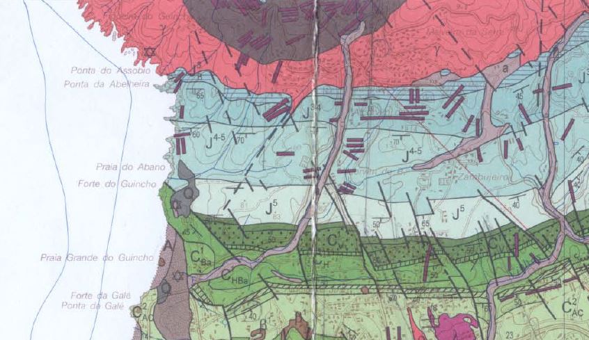
Geological setting at GZ
According to Ramalho et al., (2001), the sequence of rocks that outcrops here is denominated “limestones schists with intercalated marls and conglomerates” of Upper Oxfordian age superior to Lower Kimmeridgian (somewhere around 157 M.a.). Within the limestones are fine-grained detritic facies.
To register this Earthcache get to the coordinates, answer the following questions and send me the answers through my profile:
- Look at the light brown outcrop carefully and tell me what grain size is present? Is it > 5mm or < 5mm?
- Rub your finger on the outcrop. Does the rock crumble? Or not?
- In this outcrop, there are several tafoni (hollows). What is the measurement of the long axis of the biggest ones?
- Does the outcrop have more tafoni in the vicinity or are the ones at GZ the only ones?
- Estimate the area of the outcrop (in m2)

O que é um arenito?
O arenito é uma rocha sedimentar clástica composta principalmente por partículas minerais de tamanho de areia (0,0625 a 2 mm) ou fragmentos de rocha. A maioria dos arenitos é composta de quartzo ou feldspato (ambos silicatos) porque são os minerais mais resistentes aos processos de intemperismo na superfície da Terra. Os arenitos são classificados segundo o esquema de FOLK.
Como é formado?
A formação de arenito envolve dois estágios principais. Primeiro, uma camada ou camadas de areia se acumulam como resultado da sedimentação, seja da água (como em um riacho, lago ou mar) ou do ar (como no deserto). Tipicamente, a sedimentação ocorre pela areia que se estabiliza da suspensão; isto é, deixando de ser enrolado ou ressaltado ao longo do fundo de uma massa de água ou superfície do solo. Finalmente, uma vez acumulada, a areia se transforma em arenito quando é compactada pela pressão de depósitos sobrejacentes e cimentada pela precipitação de minerais dentro dos espaços de poros entre grãos de areia.
Onde é formado?
- Os arenitos podem-se formar em dois tipos gerais de ambiente: 1- Ambientes terrestres (rios, leques aluviais, glaciares, lagos e desertos) e, 2- ambientes marinhos (deltas, praias, planícies de maré, bares ao largo, tempestades (depósitos) e turbiditos.
Uso
O arenito é frequentemente usado como material de construção.
Enquadramento Geológico
Segundo Ramalho et al., (2001), estamos numa sequência denominada “calcoxistos com intercalações margosas e níveis conglomeráticos” de idade Oxfordiano superior a Kimeridgiano inferior (à volta dos 157 milhões de anos). Aqui, no seio dos calcários, existem passagens a unidades detríticas de grão fino.
Para registares esta EarthCache:
Para registrar este EarthCache, dirige-te às coordenadas, responde às seguintes perguntas e envia-me as respostas através do meu perfil
- Olha para o afloramento castanho claro com cuidado e diz-me qual o tamanho do grão que está presente? É > 5mm ou <5mm?
- Esfregua o dedo no afloramento. A rocha desmorona? Ou não?
- Neste afloramento, existem vários tafoni (cavidades). Qual é a medida do eixo longo dos maiores?
- O afloramento tem mais tafoni nas proximidades ou são os únicos no GZ?
- Estima a área do afloramento (em m2).

 The most exciting way to learn about the Earth and its processes is to get into the outdoors and experience it first-hand. Visiting an Earthcache is a great outdoor activity the whole family can enjoy. An Earthcache is a special place that people can visit to learn about a unique geoscience feature or aspect of our Earth. Earthcaches include a set of educational notes and the details about where to find the location (latitude and longitude). Visitors to Earthcaches can see how our planet has been shaped by geological processes, how we manage the resources and how scientists gather evidence to learn about the Earth. To find out more click HERE.