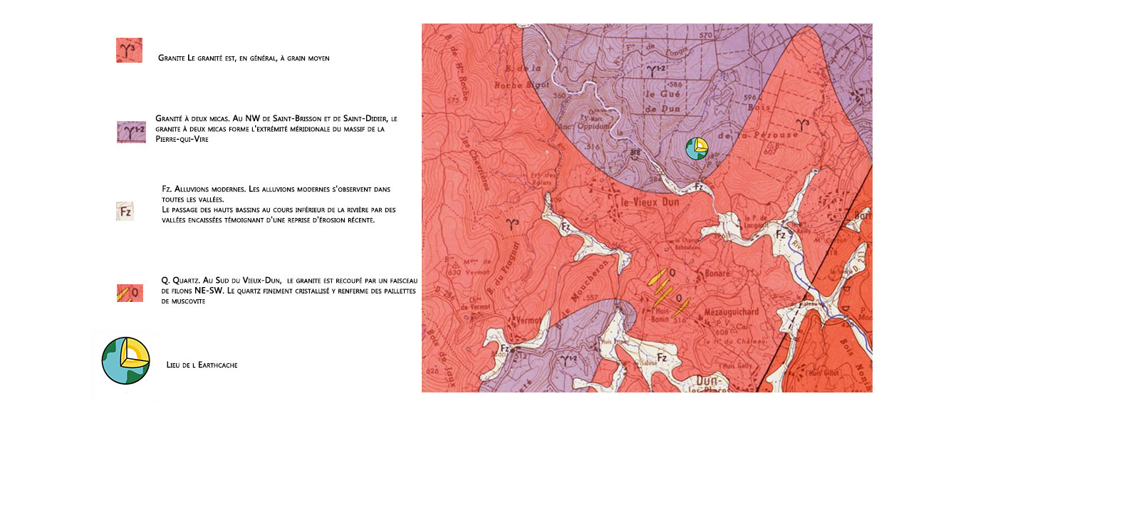
Rocher de la Pérouse et son panorama
Le Rocher de la Pérouse est situé à 556 mètres d'altitude, ce qui en fait le point culminant du département de l'Yonne.
Cette situation particulière lui confère deux points d’intérêt : un chaos granitique spectaculaire mais aussi un superbe panorama sur le Morvan Nivernais.
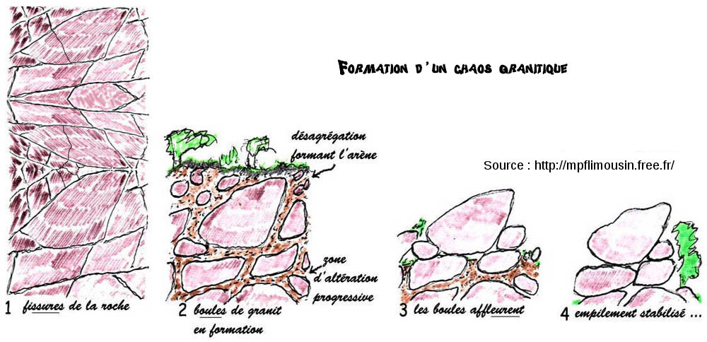
A Chaos
Les chaos granitiques sont le résultat de l'altération en boules des granites, boules qui sont dégagées par l'érosion
Voici un schéma pour comprendre sa formation :
B Panorama
Le paysage qui s’offre est le résultat de la tectonique des Alpes, avec un découpage des blocs, différence d’altitude entre les compartiments de l’ancienne surface d’érosion.
Vers le Sud Ouest, il offre une vue très typique du Morvan nivernais, qui se perd au loin dans l’horizon.
Au premier plan, la Cure, dans l’entaille de la fracture Sud Est – Nord Ouest au contact du granit et microgranite
Au dela, un premier niveau de plateau à 500m, puis plus loin la forêt vers 600m.
Rocher de la Pérouse and his panorama
Rocher de la Perouse is located at an altitude of 556 meters, making it the highest point in the Yonne department.
This particular situation gives it two points of interest: a spectacular granite chaos but also a great panorama on the Morvan Nivernais.
A Chaos
The granitic chaos is the result of the alteration into granite balls, balls that are released by erosion
Here is a diagram to understand his training :
B Panorama
The landscape that is offered is the result of the tectonics of the Alps, with a division of the blocks, difference of altitude between the compartments of the old surface of erosion.
Towards the South West, it offers a very typical view of the Nivernais Morvan, which is lost far off in the horizon.
In the foreground, the Cure, in the notch of the South East - North West fracture in contact with granite and microgranite
Beyond, a first level of plateau at 500m, then further the forest towards 600m.
Rappel concernant les « Earthcaches »: Il n'y a pas de conteneur à rechercher ni de logbook à renseigner. Il suffit de se rendre sur les lieux et d'éxécuter les requêtes du geocacheur.
Loguez cette cache "Found it" et envoyez-moi vos propositions de réponses soit via mon profil, soit via la messagerie geocaching.com (Message Center), EN PRECISANT LE NOM ET CODE GC DE LA CACHE et je vous contacterai en cas de problème.
Il est aussi apprécié d'avoir des photos des géocacheurs sur les lieux de l''EarthCache. Sentez vous inspiré de poster des photos de vous lors de cette visite ( optionnelle mais sympathique)
---
Reminder concerning "Earthcaches": there is neither a container to look for nor a logbook to sign.
Log in this cache " Found it " and send me your answers proposals or via my profile or via geocaching.com messaging (Message Center ) , BY PROVIDING THE NAME AND GC CODE OF THE CACHE and I will contact you in case of problems .
We also enjoy seeing photographs of people visiting this EarthCache. Please feel free to log photos of your visit...(this is entirely optional but funny)
Grace à la lecture du descriptif et votre observation, répondez aux questions suivantes :
Thanks to the reading of the description and your observation, answer the following questions:
Q1 En vous basant sur le schema de formation d’un chaos granitique, dites moi à quel etape se trouve
:a) le Waypoint XX ?
b)Le WaypointYY ?
Q2 Dessinez un schéma du paysage avec Le Rocher de la Perouse (où vous êtes situé) , la Cure, les failles, le Mont Moucheron, Le Haut du Château et le Mont Cortot.
Q3 Les décalages qui sont à la verticale de ce point de vue vous semblent-t-il récents ?
Q4 (Facultatif) Une photographie de vous/votre GPS en ces lieux en noir et blanc
Q1
Q1 Based on the pattern of granite chaos, tell me which stage is

: a) Waypoint XX?

 b) WaypointYY?
Q2 Draw a diagram, of the landscape with The Rock of the Perouse ( where you are), the Cure, the faults, the Mount Moucheron, the Top of the Castle and Mont Cortot
Q3 Are the offsets that are vertical from this point of view recent? Justify your answer
Q4 (optionnal) A photo of you or your GPS in these spot in Black and White
JOYEUX & HAPPY EARTHCACHING