Experience this EarthCache
This Earthcache will take you to Riverboat Row in Newport, Kentucky. From the listed coordinates, you should have a beautiful view of downtown Cincinnati and the lovely Ohio River. To your right is the Route 27 bridge connecting the two cities. We brought you here to observe a river flood gauge (of sorts) and some engineering designed to ease the effects of Ohio River floods on both sides of the river.
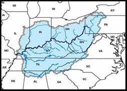
The Ohio River near Cincinnati experiences regular flooding, as the upstream watershed (water source area) for the river is quite extensive. The Ohio River begins at the confluence (intersection) of three rivers in Pittsburgh, PA. As for the watershed, the eastern sector extends from southern New York state all the way into southern Tennessee and North Carolina. Note that many tributaries from the Appalachians also feed this giant river (Figure 1), which means high runoff during the springtime snow melt.
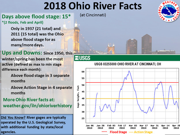
In 2018, Cincinnati experienced significant flooding of the Ohio River. Smale Riverfront Park, which lies across the river from where you stand, was submerged in the floodwaters. The following graphic details Cincinnati’s 2018 flood event.
Look at the flood gauge (giant ruler) on the side of the bridge to your right. Why are the numbers going in the wrong order? – You may ask. This is so vessels traveling the Ohio River know how much clearance they have when going under the bridge. During floods, bridges can be hazardous to ships.
* Source research and text by LtStabos.
Logging Requirement:
Once you log this Earthcache as "FOUND" please message us the answer to the following question within 1 hour.
- How much clearance would a passing ship have under the bridge today, based on the flood gauge on the bridge pillar?
- Look around you – do you see any evidence of flood damage? If so, what is it?
- What types of flood control have local engineers put in place in this area?
GeoTour Question:
For your GeoTrail Passport you will need to collect the following answer.
- What is the lowest number (numerically) on the flood gauge?
To access the Earthcaching 101 GeoTour Digitial Passport: CLICK HERE.
EarthCaching 101 GeoTour Locations:
- ECGT A Walk Through Time (GC7P5RE)
- ECGT Rocks of Fountain Square (GC7P5RG)
- ECGT Ohio River Flood Gauge (GC7P5RJ)
- ECGT Very Old Logs (GC7P5RM)
- ECGT Mount Adams Landslide Hazard (GC7P5RN)
- ECGT Cincinnati River Valleys (GC7P5RQ)
- ECGT "Glacial Erratic" (GC7P5RT)
- ECGT Pervious Pavement (GC7P5RW)
- ECGT Forest Avenue Wetland (GC7P5RZ)
- ECGT Cincinnati Fossils and Stratigraphy (GC7P5T1)