Cette earth complète le parcours de "la lande des Potiers" de Klaskav, dont voici le départ : https://coord.info/GC6Y26C. C'est l'owner qui m'a proposé d'insérer une earth dans son circuit et je l'en remercie.
 AUJOURD’HUI
Le site est classé Natura 2000 depuis 2007.
Le sol que vous allez fouler sur le parcours de la lande a fait l’histoire de La Poterie. Vous pourrez ainsi le long du parcours « la lande de la Poterie », voir la matière première qu’utilisaient les potiers et ce qu’il reste de leurs passages.
Autour de vous, on dénombre environ 410 trous appelés caves (excavations sèches ou humides) dans lesquels l’argile était puisée. Avec le temps, les caves ont été transformées en petites mares qui abritent aujourd’hui une multitude d’espèces. D’une mare à l’autre, le niveau de l’eau est différent : leur fond, colmaté par les argiles, est imperméable. Il n’y a pas d’échange d’eau entre les mares.
GEOLOGIE
La Poterie est située sur du gabbro dit « de Trégomar », une commune voisine. Ce massif, formé il y a 590 millions d’année à l’ère primaire, s’étend sur 12km2 environ. Il est intrusif dans les schistes et phtanites de Lamballe (Briovérien moyen). C’est l'un des plus volumineux et le mieux circonscrit du département des Côtes d'Armor.
Le gabbro est une roche peu courante. C’est une roche grenue qui doit sa formation à un refroidissement en profondeur, au niveau des dorsales océaniques, d'un magma produit dans le manteau supérieur à la suite de la fusion partielle de ses péridotites.
À la différence du basalte, le gabbro se refroidit lentement, ce qui lui permet de mieux se cristalliser. Il s'agit donc d'une roche de couleur sombre dite plutonique. Elle compose la majeure partie de la zone inférieure des croûtes océaniques. Plusieurs minéraux entrent dans sa composition, comme le plagioclase, le pyroxène, l'amphibole et l'olivine.
Le gabbro, de même composition que le basalte, cristallise lentement en profondeur, de même que la péridotite, à laquelle il est souvent associé. Il constitue notamment la couche profonde de la croûte océanique, sous la couche basaltique. Le rencontrer est donc rare.
L’ARGILE
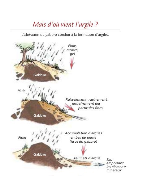
L’altération de la roche a fait d’elle une source d’argile. Ce sont les potiers qui en ont profité. L’argile a été exploitée ici pendant plus de 1 000 ans. Les premières traces écrites d’une production datent de 1084. À son apogée, 250 potiers y produisaient jusqu’à un million de pots par an.
Selon un décompte, en 1900, il restait 7 fours, le dernier s'est éteint vers 1920. Le lieu a conservé, témoignage de son passé, les trous appelés caves dans lesquels l’argile était puisée.
En regardant de près le gabbro, vous pourrez observer que les 2 principaux cristaux s’enchevêtrent donnant à la roche une grande dureté (quand elle n’est pas altérée bien sûr). Les cristaux sombres contiennent beaucoup de fer, ce qui facilite l’altération dès que la roche approche de la surface et que l’eau pénètre dans les fissures. C’est ainsi qu’apparaît l’argile.
 TODAY
TODAY
The site is classified Natura 2000 since 2007.
The soil that you will tread on the course of the moor made the history of La Poterie. You will be able to see along the route "the moor of Pottery", see the raw material used by the potters and what remains of their passages.
Around you, there are about 410 holes called cellars (dry or wet excavations) in which the clay was drawn. With time, the cellars have been transformed into small pools that today shelter a multitude of species. From one pond to another, the water level is different: their bottom, clogged with clays, is impermeable. There is no exchange of water between the pools.
GEOLOGY
Pottery is located on the gabbro said "Trégomar", a neighboring town. This massif, formed 590 million years ago in the primary era, covers about 12km2. It is intrusive in schists and phtanites from Lamballe (Middle Brioverian). It is one of the largest and best circumscribed of the department of Côtes d'Armor.
The gabbro is an unusual rock. It is a granular rock that owes its formation to a deep cooling, at the level of the oceanic ridges, of a magma produced in the upper mantle as a result of the partial melting of its peridotites.
Unlike basalt, the gabbro cools slowly, allowing it to crystallize better. It is therefore a dark rock called plutonic. It composes most of the lower zone of the ocean crusts. Several minerals come into its composition, such as plagioclase, pyroxene, amphibole and olivine.
The gabbro, with the same composition as the basalt, crystallizes slowly in depth, as does the peridotite, to which it is often associated. In particular, it constitutes the deep layer of the oceanic crust beneath the basaltic layer. To meet him is rare.
CLAY
The weathering of the rock has made it a source of clay. It was the potters who took advantage of it. The clay has been exploited here for more than 1,000 years. The first written records of a production date back to 1084. At its peak, 250 potters produced up to a million pots a year.
According to a count, in 1900, there are 7 kilns, the last one goes out around 1920. The place has preserved, testimony of its past, the holes called cellars in which the clay was drawn.
Looking closely at the gabbro, you can see that the 2 main crystals entangle giving the rock a great hardness (when it is not altered course). Dark crystals contain a lot of iron, which facilitates weathering as the rock approaches the surface and water penetrates the cracks. This is how clay appears.
 |
 |
| QUESTIONS |
QUESTIONS |
|
Le WP de cette earth vous emène sur un point de vue ou vous pourrez admirer les landes et le gabbro encore visible en surface.
-
Avant de vous engager vers le point de vue situé à une dizaine de mètres, une borne en bois vous indique qu’il faut tourner. Quel est son numéro et son symbole ?
-
Pourquoi y a-t-il toutes ces caves dans la lande ?
-
Pourquoi est ce rare de voir du gabbro ?
-
Comment obtient-on de l’argile ?
-
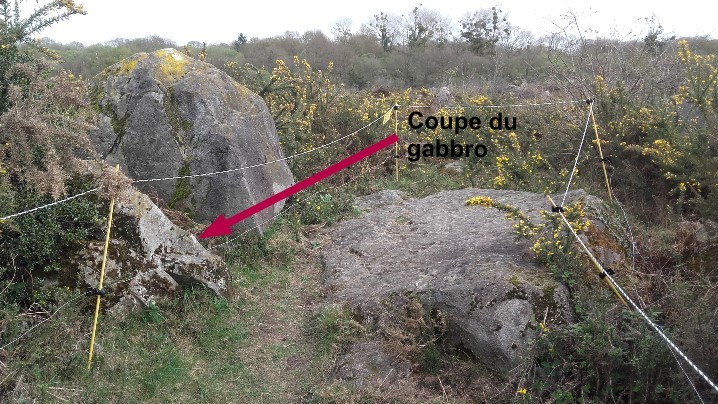
Etude de la roche : afin d’étudier de plus près la roche, le gabbro a été taillé (taille indiquée sur la photo) afin de laisser apparaître une coupe propre. Quelle est sa couleur ? Quelle est la texture de la roche (passer votre doigt dessus) ?
|
The WP of this earth takes you on a point of view where you will be able to admire the moors and the gabbro still visible on the surface.
1. Before you make your way to the 10-meter point of view, a wooden sign tells you to turn. What is its number and symbol?
2. Why are all these "holes" in the moor?
3. Why is it rare to see gabbro?
4. How do you get clay?
5. Study of the rock: in order to study more closely the rock, the gabbro was cut (size indicated in the photo) in order to reveal a clean cut. What is her color ? What is the texture of the rock (put your finger on it)?
|
"Loguez cette cache "Found it" et envoyez-moi vos propositions de réponses soit via mon profil, soit via la messagerie geocaching.com (Message Center), et je vous contacterai en cas de problème."