Site minier des ferrières 1/3 EarthCache
Site minier des ferrières 1/3
-
Difficulty:
-

-
Terrain:
-

Size:  (other)
Please note Use of geocaching.com services is subject to the terms and conditions
in our disclaimer.
Histoire de la concession des Ferrières :
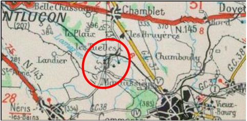
Située au nord-est de Néris-les-Bains et à l’ouest de Commentry. Elle avait une superficie initiale de 3,69 km². Elle fut traversée, de 1846 à 1825, par le chemin de fer minier de Montluçon à Commentry et à partir de 1859, par le chemin de fer de Montluçon à Moulins.
Le gisement fut exploité de façon souterraine, par 18 puits de mine. En 1900, huit d’entre eux sont recensés du nord au sud :
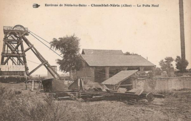
Puits de la Charbonnière, Puits de l’Espérance, Puits du Manège, Puits de la Machine, Puits Saint-Isidore, Puits Saint-Etienne ①, Puits des Forettes, Puits Neuf ②
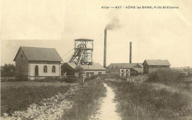
Le puits Saint-Etienne, était le puits le plus important de la concession. En 1900, il descendait à plus de 340 mètres ( cf. photo ① ).
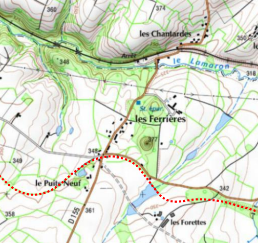
Le puits Neuf était situé au sud-ouest de la concession. La profondeur de 360 mètres aurait été atteinte. Le puits aurait fermé le 1er janvier 1955. ( cf. photo ② ).
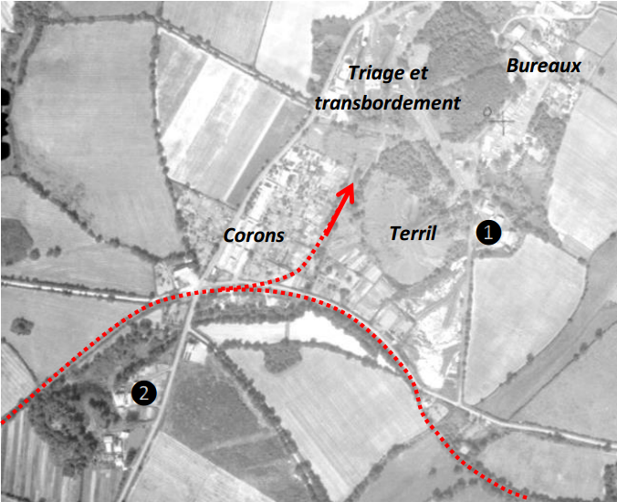
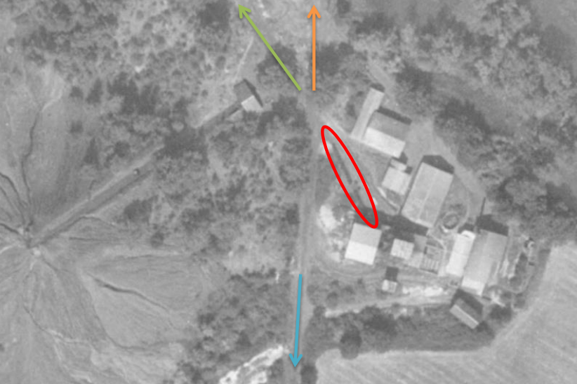
Ci-dessous, le puits Saint-Etienne. Des wagonnets sont visibles. La flèche verte indique la direction du centre de triage du charbon. La flèche orange indique la direction des bureaux, devant lesquels était stocké le bois d’étayage. Un plan incliné permet d’acheminer les bennes au sommet du terril. Les derniers puits ferment vers 1950.
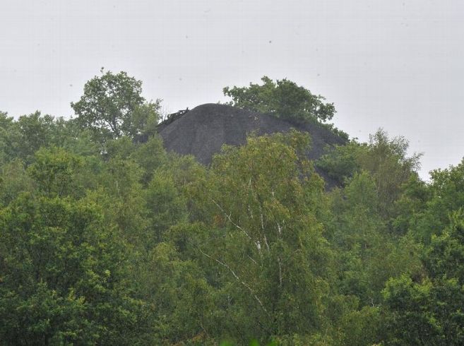
Le terril disparaît progressivement sous la végétation.
Formation d'un terrils :
Un terril, est une colline artificielle construite par accumulation de résidu minier, sous-produits de l'exploitation minière, composés principalement de schistes, et en plus petite quantité de grès carbonifères et de résidus divers (quelquefois pollués). Le terril de Néris les Bains, édifié vers 1900, est une formation très récente à l'échelle géologique mais n'en est pas moins soumis aux aléas de l’érosion. Cette dernière est essentiellement provoquée par l’action de l’eau atmosphérique, qui intervient sous plusieurs formes :
D’une part, l'eau participe à la désagrégation du schiste par infiltration dans les plans de schistosité. En période de gel, l’augmentation du volume de la glace fait éclater les blocs de schiste et les transformes en amoncellements de feuillets. En période plus douce et humide, la désagrégation se poursuit sous l'effet de la dilatation.
A côté de cette action purement mécanique, l’eau intervient dans les processus chimiques conduisant à la dissolution du schiste.
Plus indirectement, la désagrégation du schiste par l’eau le rend plus facilement transportable. En cas de pentes accentuées et lors des fortes pluies, l’eau concentrée au fond d’un chenal d’écoulement peut favoriser la formation d’incisions linéaires appelées des ravines, et déposer des matériaux à la base du terril en formant de petites accumulations, les cônes de déjection.
Les différents types de terril :
Plats : Les terrils plats sont très répandus au XVIIIe siècle et XIXe siècle, le déversement est fait horizontalement sur la longueur. Ils ont souvent une largeur variable. Ils peuvent également être déversés à flanc de colline.
Coniques : Ces terrils sont construits par des déversement verticaux, lui donnant une forme de cône, ce type est particulièrement répandu au XXe siècle.
Tronqué : Ce type est identique au précédent mais avec un sommet plat.
Modernes : Les terrils modernes sont formés d'un ensemble de terrils coniques et sont plus massifs. Ce type est apparu avec les grandes infrastructures construites après la seconde guerre mondiale.
Cavaliers : Ce sont des terrils plats utilisés pour installer des voies ferrés.
Questions :
1 - En vous aidant des informations dans la description de la cache, de quel type de terril s'agit il ?
2 - Au sommet ce trouve un objet à moitié enfoui, avec les informations ci dessus et grâce au bâtiment en contre bas de quoi s'agit il ?
3 - Aux coordonnées, comment appelle t'on la forme d'érosion visible sur le versant ?
4 - Aux coordonnées, que donnent les schistes en se dégradant par dissolution ?
5 - ( Optionnel ) N'hésitez pas à publier des photos du paysage.
Rappel concernant les « Earthcaches » : Il n'y a pas de conteneur à rechercher ni de logbook à renseigner. Il suffit de se rendre sur les lieux et d'exécuter les requêtes du propriétaire de la cache.
Loguez cette cache "Found it" et envoyez-moi vos propositions de réponses soit via mon profil, soit via la messagerie geocaching.com (Message Center), et je vous contacterai en cas de problème.
Bon Earthcaching !
History of the Ferrières concession :
Located north-east of Neris-les-Bains and west of Commentry. It had an initial area of 3.69 km². It was crossed, from 1846 to 1825, by the mining railway from Montluçon to Commentry and from 1859, by the railway from Montluçon to Moulins.
The deposit was mined underground by 18 mine shafts. In 1900, eight of them are listed from north to South :
Well of Charbonnière, Well of Hope, Well of Armory, Well of Machine, Well St. Isidore, Well St. Stephen ①, Well of Forests, New Well ②
The Saint-Etienne well, was the most important well of the concession. In 1900, it went down more than 340 meters ( see photo ① ).
Well Nine was located southwest of the concession. The depth of 360 meters would have been reached. The well is reported to have closed on 1 January 1955. ( see photo ② ).
Below, the Saint-Etienne well. Carts are visible. The green arrow indicates the direction of the coal sorting center. The orange arrow indicates the direction of the offices, in front of which was stored the shingles. An inclined plane makes it possible to transport the skips to the top of the heap. The last wells close around 1950.
The slag gradually disappears under the vegetation.
Formation of a heap :
A slag heap is an artificial hill built by the accumulation of mine tailings, by-products of mining, composed mainly of shale, and in smaller quantities of carboniferous sandstones and various residues (sometimes polluted). The terril of Néris les Bains, built from 1900, is a very recent formation on the geological scale but is nonetheless subject to the hazards of erosion. The latter is essentially caused by the action of atmospheric water, which comes in several forms :
On the one hand, water participates in the disintegration of shale by infiltration in schistosity plans. In frosty weather, the increase in ice volume causes the shale blocks to burst and the transformations to form leaflets. In a softer and moister period, the disintegration continues under the effect of the dilation.
In addition to this purely mechanical action, water is involved in the chemical processes leading to the dissolution of shale.
More indirectly, the disintegration of shale by water makes it more easily transportable. In case of steep slopes and heavy rains, concentrated water at the bottom of a flow channel can promote the formation of linear incisions called gullies, and deposit materials at the base of the heap forming small accumulations. , the excrement cones.
The different types of slag :
Dishes : The flat heaps are widespread in the eighteenth century and nineteenth century, the spill is made horizontally along the length. They often have a variable width. They can also be dumped on a hillside.
Conical : These heaps are built by vertical spills, giving it a cone shape, this type is particularly widespread in the twentieth century.
Truncated : This type is identical to the previous one but with a flat top.
Modern : Modern slag heaps are formed of a set of conical heaps and are more massive. This type appeared with the large infrastructures built after the Second World War.
Riders : These are flat heaps used to install railroad tracks.
Questions :
1 - By helping you with the information in the description in the cache, what type of slag is it ?
2 - At the top is an object half buried, with the above information and thanks to the building against what is it ?
3 - Coordinates, what do you call the visible erosion form on the slope ?
4 - At the coordinates, what do the shales give by being degraded by dissolution ?
5 - (Optional) Do not hesitate to publish photos of the landscape.
Earthcache reminder : There is no container to search for and no logbook to fill out. All you have to do is go to the scene and execute the cache owner's requests. Log this cache "Found it" and send me your suggestions for answers either through my profile or via the messaging geocaching.com (Message Center), and I will contact you in case of problems.
Good Earthcaching !
Additional Hints
(No hints available.)